

View Information About HSR Ratings

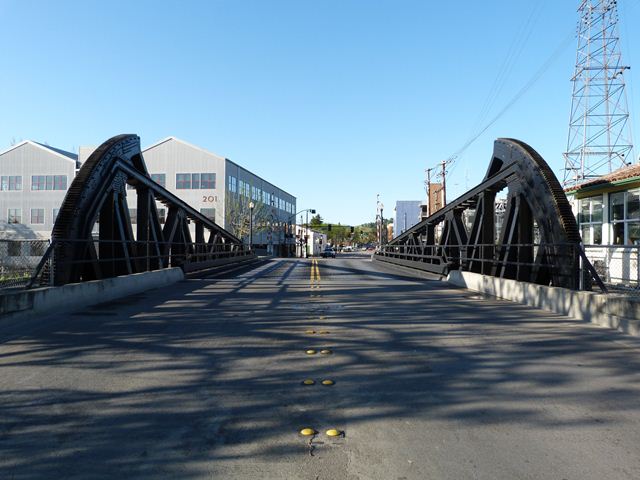
Dating to 1933, this bridge is a rare example of a single leaf highway bascule bridge. It features a truss superstructure. Like most bascule bridges, the depth of the truss is variable, being greater at the counterweight end of the bridge. However, unlike many truss bascule bridges, the top chord is not polygonal or curved, and instead follows the same angle throughout its length. This gives the overall truss an unusual triangular appearance. The bascule is a fixed trunnion design with the counterweight under the roadway in a tail pit. Unusual among fixed trunnion bascules with under-deck counterweights built during this period, the operating rack for the bridge is on the exterior of truss, facing outward, away from the bridge. In other words, the rack is out in the open and easily visible. Compare this to the city of Chicago which specialized in building fixed trunnion bascule bridges. Within ten years of building bridges of this type, Chicago quickly switched from an outward facing rack to placing the rack inward facing behind the end of the truss. This concealed the rack within the truss web, making the bridge more aesthetically pleasing by making the mechanical element less visible. The consulting engineer who designed this bridge, Leon H. Nishkian definitely had a preference for the outward facing rack however. Visit the 3rd Street Bridge page to learn more about Leon H. Nishkian and to see another bascule bridge he designed with outward facing operating racks.
![]()
![]()
![]()
Coordinates (Latitude, Longitude):
Search For Additional Bridge Listings:
Bridgehunter.com: View listed bridges within 0.5 miles (0.8 kilometers) of this bridge.
Bridgehunter.com: View listed bridges within 10 miles (16 kilometers) of this bridge.
Additional Maps:
Google Streetview (If Available)
GeoHack (Additional Links and Coordinates)
Apple Maps (Via DuckDuckGo Search)
Apple Maps (Apple devices only)
Android: Open Location In Your Map or GPS App
Flickr Gallery (Find Nearby Photos)
Wikimedia Commons (Find Nearby Photos)
Directions Via Sygic For Android
Directions Via Sygic For iOS and Android Dolphin Browser
USGS National Map (United States Only)
Historical USGS Topo Maps (United States Only)
Historic Aerials (United States Only)
CalTopo Maps (United States Only)

© Copyright 2003-2026, HistoricBridges.org. All Rights Reserved. Disclaimer: HistoricBridges.org is a volunteer group of private citizens. HistoricBridges.org is NOT a government agency, does not represent or work with any governmental agencies, nor is it in any way associated with any government agency or any non-profit organization. While we strive for accuracy in our factual content, HistoricBridges.org offers no guarantee of accuracy. Information is provided "as is" without warranty of any kind, either expressed or implied. Information could include technical inaccuracies or errors of omission. Opinions and commentary are the opinions of the respective HistoricBridges.org member who made them and do not necessarily represent the views of anyone else, including any outside photographers whose images may appear on the page in which the commentary appears. HistoricBridges.org does not bear any responsibility for any consequences resulting from the use of this or any other HistoricBridges.org information. Owners and users of bridges have the responsibility of correctly following all applicable laws, rules, and regulations, regardless of any HistoricBridges.org information.
![]()