We Recommend:
Bach Steel - Experts at historic truss bridge restoration.
BridgeHunter.com Phase 1 is released to the public! - Visit Now
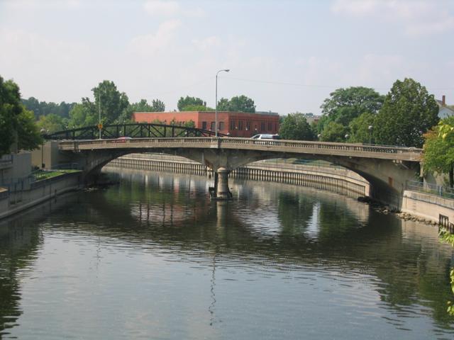
Beach-Garland Street Bridge

Primary Photographer(s): Nathan Holth
Bridge Documented: August 14, 2003 and April 17, 2006
Flint: Genesee County, Michigan: United States
1921 By Builder/Contractor: Illinois Bridge Company of Chicago, Illinois
Not Available or Not Applicable
80.0 Feet (24.4 Meters)
172.0 Feet (52.4 Meters)
38 Feet (11.58 Meters)
2 Main Span(s)
254238800260B01

View Information About HSR Ratings
Bridge Documentation
This bridge no longer exists!
View Archived National Bridge Inventory Report - Has Additional Details and Evaluation
This historic bridge was demolished in Summer 2006.
This bridge was one of a few extremely rare concrete arch bridges in Flint. They are rare because they were built to a Luten patent. Luten arch bridges are very significant and deserve preservation. The Beach-Garland Street Bridge also had significance as a heavily skewed arch bridge. Unfortunately, Flint did not care about this, and they demolished this beautiful historic bridge.
This bridge had deteriorated severely, despite its generous 60 ton posted weight limit. The decay was mainly visible on the cantilevers for the sidewalks, which had nearly completely spalled away in spots, leaving reinforcing rods hanging out. Understandably, there were signs posted at the approaches to this bridge that say "sidewalk closed."
Flint is a city that is turning into a ghost town partly due to the decline of the auto industry. But one has to wonder that if perhaps Flint's ignorance of its attractive historic bridges such as the Beach-Garland Street Bridge, and other areas of heritage and beauty in the city has also discouraged people from wanting to live in Flint. If Flint had preserved its Luten arch bridges, it could today claim to be one of the few cities that still has a Luten arch. Preserving attractions like this arch bridge are key elements that can help to boost the success of a downtown area.
Information and Findings From Michigan Historic Bridge InventoryNarrative Description
Located
west of Interstate 475, this two-span concrete bridge spans the Flint
River in central Flint. Known alternately as the Beach Garland Bridge or
the Garland Beach Street Bridge, the structure joins Beach and Garland
Streets in the central business district. The bridge has two, heavily
skewed, 80-foot, filled spandrel arches by incised lines in the
concrete. |
This bridge is tagged with the following special condition(s): Luten and Unorganized Photos
![]()
Photo Galleries and Videos: Beach-Garland Street Bridge
Bridge Photo-Documentation
A collection of overview and detail photos. This photo gallery contains a combination of Original Size photos and Mobile Optimized photos in a touch-friendly popup viewer.Alternatively, Browse Without Using Viewer
![]()
Additional Unorganized Photos
Original / Full Size PhotosThis photo gallery features older ca. 2003-2006 photos taken when the website only included a few photos in original size on the website, and a smaller quantity of reduced size photos as well. This unorganized gallery may partially duplicate photos in other galleries on this bridge's page, however all photos here are available in the Original / Full Size. This gallery offers photos in the highest available resolution and file size in a touch-friendly popup viewer.
Alternatively, Browse Without Using Viewer
![]()
Additional Unorganized Photos
Mobile Optimized PhotosThis photo gallery features older ca. 2003-2006 photos taken when the website only included a few photos in original size on the website, and a smaller quantity of reduced size photos as well. This unorganized gallery may partially duplicate photos in other galleries on this bridge's page, however all photos here are available in the Original / Full Size. This gallery features data-friendly, fast-loading photos in a touch-friendly popup viewer.
Alternatively, Browse Without Using Viewer
![]()
Maps and Links: Beach-Garland Street Bridge
This historic bridge has been demolished. This map is shown for reference purposes only.
Coordinates (Latitude, Longitude):
Search For Additional Bridge Listings:
Bridgehunter.com: View listed bridges within 0.5 miles (0.8 kilometers) of this bridge.
Bridgehunter.com: View listed bridges within 10 miles (16 kilometers) of this bridge.
Additional Maps:
Google Streetview (If Available)
GeoHack (Additional Links and Coordinates)
Apple Maps (Via DuckDuckGo Search)
Apple Maps (Apple devices only)
Android: Open Location In Your Map or GPS App
Flickr Gallery (Find Nearby Photos)
Wikimedia Commons (Find Nearby Photos)
Directions Via Sygic For Android
Directions Via Sygic For iOS and Android Dolphin Browser
USGS National Map (United States Only)
Historical USGS Topo Maps (United States Only)
Historic Aerials (United States Only)
CalTopo Maps (United States Only)


