We Recommend:
Bach Steel - Experts at historic truss bridge restoration.
BridgeHunter.com Phase 1 is released to the public! - Visit Now
Warwick Bridge

Primary Photographer(s): Nathan Holth
Bridge Documented: June 28, 2005
Warwick Township: Lambton County, Ontario: Canada
2004
64.5 Feet (19.7 Meters)
Not Available
Not Available
1 Main Span(s)
Not Applicable

View Information About HSR Ratings
Bridge Documentation
This bridge no longer exists!
Bridge Status: Demolished and replaced in 2019. New bridge has decorative arches that resemble the heritage bridge.2004 Narrative:
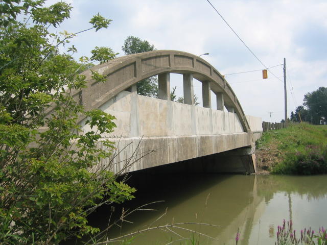
This bridge is a "rainbow arch" bridge, technically known as a concrete bowstring through arch.
Very few of Ontario's beautiful heritage rainbow arch bridges have been rehabilitated. However, Lambton County made a smart and sensible decision to rehabilitate this beautiful bridge. It is a nice gateway into the tiny village of Warwick coming from the east, and is a beautiful example of an noteworthy type of bridge. It should continue to be a beautiful landmark for the Warwick area for many years to come.
The rehabilitation of the bridge maintained the historic integrity of the bridge with the one exception being that the railings were replaced.
Mary K. Villalba contacted HistoricBridges.org and noted that a newspaper article indicated that her grandfather Stanley Vaughan Jones was superintendent for the construction of the bridge.
2019 Update:
Despite the 2004 rehab, in 2019, this bridge was demolished and replaced, a sad outcome to be sure. However, the new bridge, a 23.0 meter span bridge of prestressed concrete girders, while lacking heritage significance, does incorporate decorative arches that closely resemble the load-bearing arches of the former heritage bridge. This was the outcome of the Environmental Assessment for the project which included community input that indicated a desire to retain the landmark appeal of the arches. Thus, visitors can still visit this bridge and get a rough idea what the historic bridge looked like, particularly from the perspective of driving across the bridge. The effort is worth noting because the proportions of the decorative arch closely resemble the heritage bridge, this is not often the case when new bridges attempt to replicate desirable features of a heritage bridge that is replaced. Below are photos of the new bridge courtesy of Andrew Ross P.E. of B. M. Ross and Associates Limited who designed the replacement bridge.
This bridge is tagged with the following special condition(s): Unorganized Photos
![]()
Photo Galleries and Videos: Warwick Bridge
Bridge Photo-Documentation
A collection of overview and detail photos. This photo gallery contains a combination of Original Size photos and Mobile Optimized photos in a touch-friendly popup viewer.Alternatively, Browse Without Using Viewer
![]()
Additional Unorganized Photos
Original / Full Size PhotosThis photo gallery features older ca. 2003-2006 photos taken when the website only included a few photos in original size on the website, and a smaller quantity of reduced size photos as well. This unorganized gallery may partially duplicate photos in other galleries on this bridge's page, however all photos here are available in the Original / Full Size. This gallery offers photos in the highest available resolution and file size in a touch-friendly popup viewer.
Alternatively, Browse Without Using Viewer
![]()
Additional Unorganized Photos
Mobile Optimized PhotosThis photo gallery features older ca. 2003-2006 photos taken when the website only included a few photos in original size on the website, and a smaller quantity of reduced size photos as well. This unorganized gallery may partially duplicate photos in other galleries on this bridge's page, however all photos here are available in the Original / Full Size. This gallery features data-friendly, fast-loading photos in a touch-friendly popup viewer.
Alternatively, Browse Without Using Viewer
![]()
Maps and Links: Warwick Bridge
This historic bridge has been demolished. This map is shown for reference purposes only.
Coordinates (Latitude, Longitude):
Search For Additional Bridge Listings:
Additional Maps:
Google Streetview (If Available)
GeoHack (Additional Links and Coordinates)
Apple Maps (Via DuckDuckGo Search)
Apple Maps (Apple devices only)
Android: Open Location In Your Map or GPS App
Flickr Gallery (Find Nearby Photos)
Wikimedia Commons (Find Nearby Photos)
Directions Via Sygic For Android
Directions Via Sygic For iOS and Android Dolphin Browser


