

View Information About HSR Ratings
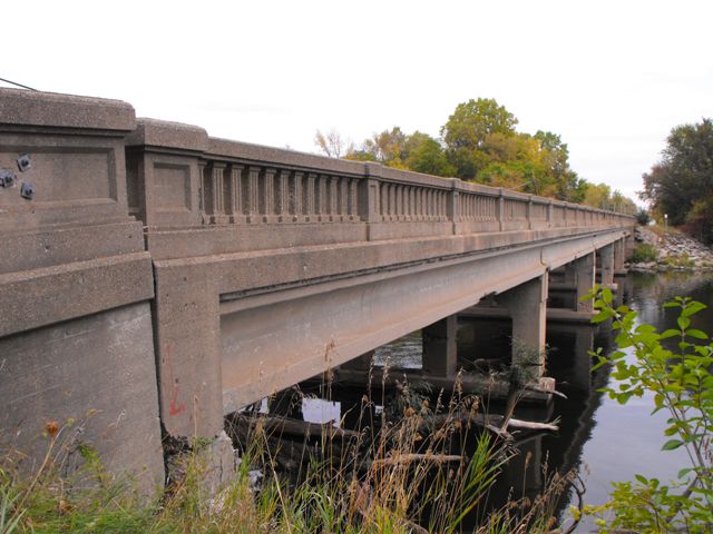
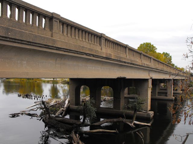
This bridge was a very long example of its type. Michigan does not have many large rivers, and as a result, this was a very long bridge of any kind for Michigan. It was also an early, 1927 example of a bridge type which was built for a very short duration, between 1927 and 1932 in Michigan. It was also significant for having a high degree of historic integrity, with no major alterations to the design of the bridge. These bridges were designed to look like they were all-concrete. They are in fact simple steel stringer (multi-beam/girder) bridges. What looks like a concrete beam, is actually a layer of cement on top of the steel of the outermost stringer. The stringers were built-up beams fabricated by the American Bridge Company, according to MDOT, and mill marks on the beams indicated the the steel itself was fabricated by Carnegie steel.
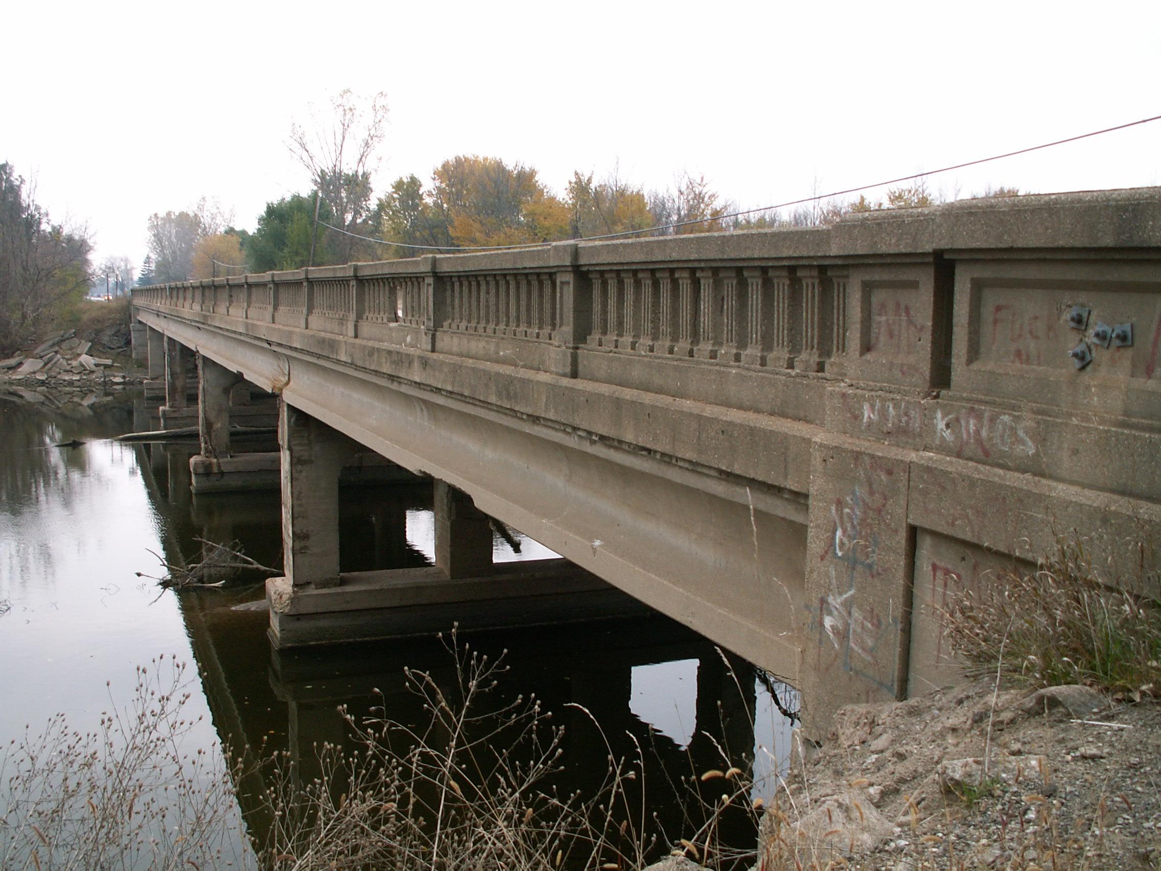
The overall condition of the bridge was good, with a 41-61-64 ton weight limit posted by 2005. By 2009, the National Bridge Inventory listed the worst part of the bridge as the substructure with a Poor (4/10) rating, with the superstructure being in Fair Condition (5/10) and the Deck being in Satisfactory Condition (6/10) . Although state and local agencies often tend to mislead the public with these ratings, "Poor" does not mean that bridge could not have been repaired, and "Fair" and "Satisfactory" actually indicate that replacement is likely a waste of money, and that rehabilitation would be a better choice. Bridges that are beyond repair generally receive much lower ratings such as Critical or Imminent Failure. A bridge that is listed Poor can still be rehabilitated for continued use. The abutments appeared to have settled, giving the railings on them an unusual angled position, indicating abutment problems. The piers had some deterioration which appeared to be from physical impact damage caused by flooding. HistoricBridges.org wishes to be more transparent than these deceptive road agencies and as such admits that this condition substructure was a problem and required substantial work. However, at the same time, HistoricBridges.org does not agree that this warranted demolition of an important historic bridge. The truth is that these substructure issues were the extent of serious concerns on this historic bridge. Minor concerns included small isolated areas of railing deterioration, which could have been easily repaired. The deck was in good condition, and the stringers under bridge appeared to be in excellent condition. Any issues with the superstructure and deck of this bridge could have easily been corrected through a rehabilitation project. While the substructure might have been more challenging, it certainly did not warrant the destruction of this large and important historic bridge. It is also worth noting that this was no narrow historic bridge. With a 30 foot roadway width, this bridge offered full two lanes of width, along with a generous shoulder. This 30 foot roadway was sufficient even for wide trucks as the below diagram with an oversize load truck on the bridge shows.

Despite the historic significance of this National Register eligible structure, Saginaw County Road Commission elected to demolish this historic bridge and replace it with a mundane slab of ugly modern construction. This project resulted in the destruction of beautiful balustrade railings with minimal concrete spalling and turned beautiful built-up steel beams with little section loss into scrap metal. Michiganders and tourists alike now have one less reason to visit the Saginaw area thanks to this shortsighted decision on the part of the road commission. The Road commission did not even give the historic bridge a chance. Neither the road commission nor local newspapers mentioned the historic significance of this bridge. Perhaps they did not want people to know? It is impossible to know for sure, but why would this information not be announced?
For Michigan's largest trucks, the weight limit on this bridge was 64 tons. This is a mere six tons short of the standard un-posted weight limit for all bridges in Michigan, which is 70 tons, which by the way is an absolutely ridiculous weight limit to place on all bridges. Many states only require 40 tons, which is much more realistic, especially for most primary and secondary roads.
To make matters worse, the county plans to build a parallel (and equally ugly) pedestrian bridge next to the ugly vehicular bridge. This is the true tragedy and evidence of county shortsightedness. Clearly an excellent preservation solution would have been to build the new bridge next to the historic bridge, and use the historic bridge for the pedestrian crossing. Even far more feasible (if less tasteful) preservation alternatives to demolition include salvaging the steel beams from the original bridge and using them to build the pedestrian bridge. Replica balustrade railings could have been constructed on the deck of this pedestrian bridge. While this really isn't a great preservation solution, it would have at least saved some of the superstructure for historical interpretation and mitigation of demolition. However, apparently engineers are not trained to be creative, and unique preservation solutions such as this are often cast aside.
Located next to a riverfront recreation area, this is a bridge that if preserved could have been appreciated by many.
Despite a gloomy fall weather every time this bridge was visited, HistoricBridges.org is proud point you to our photo gallery of over 150 photos of this bridge, neatly sorted by subject, angle, and location taken. It is hoped that these photos will serve to document this historic bridge which Saginaw County Road Commission failed to preserve for future generations to enjoy.
Information and Findings From Michigan Historic Bridge InventoryNarrative Description This
multiple-span concrete/steel bridge carries Center Road across the
Tittabawassee River in the southwestern quadrant of the city of Saginaw.
The structure is configured as five 65-foot, steel stringer spans, with
nine lines of rolled I-beams supported simply by massive concrete
abutments and spill-through piers. The outside webs of the spandrel
stringers have been encased in concrete with a coved profile, giving the
bridge and all-concrete appearance. The stringers carry a concrete deck,
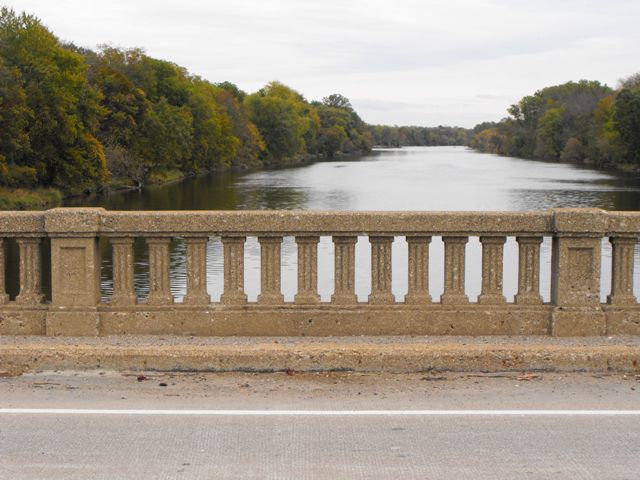
which is bounded on both sides by MSHD standard concrete guardrails with
classical fluted balusters and paneled bulkheads. Although unaltered,
the Tittabawassee River Bridge has experienced some concrete spalling on
its guardrails and spandrels. Statement of Significance Built in 1927 with a span length of 65 feet, the Tittabawassee River Bridge is representative of MSHD long-span beam bridge design of the 1920s. |
![]()
![]()
![]()
![]()
![]()
![]()
This historic bridge has been demolished. This map is shown for reference purposes only.
Coordinates (Latitude, Longitude):
Search For Additional Bridge Listings:
Bridgehunter.com: View listed bridges within 0.5 miles (0.8 kilometers) of this bridge.
Bridgehunter.com: View listed bridges within 10 miles (16 kilometers) of this bridge.
Additional Maps:
Google Streetview (If Available)
GeoHack (Additional Links and Coordinates)
Apple Maps (Via DuckDuckGo Search)
Apple Maps (Apple devices only)
Android: Open Location In Your Map or GPS App
Flickr Gallery (Find Nearby Photos)
Wikimedia Commons (Find Nearby Photos)
Directions Via Sygic For Android
Directions Via Sygic For iOS and Android Dolphin Browser
USGS National Map (United States Only)
Historical USGS Topo Maps (United States Only)
Historic Aerials (United States Only)
CalTopo Maps (United States Only)

© Copyright 2003-2026, HistoricBridges.org. All Rights Reserved. Disclaimer: HistoricBridges.org is a volunteer group of private citizens. HistoricBridges.org is NOT a government agency, does not represent or work with any governmental agencies, nor is it in any way associated with any government agency or any non-profit organization. While we strive for accuracy in our factual content, HistoricBridges.org offers no guarantee of accuracy. Information is provided "as is" without warranty of any kind, either expressed or implied. Information could include technical inaccuracies or errors of omission. Opinions and commentary are the opinions of the respective HistoricBridges.org member who made them and do not necessarily represent the views of anyone else, including any outside photographers whose images may appear on the page in which the commentary appears. HistoricBridges.org does not bear any responsibility for any consequences resulting from the use of this or any other HistoricBridges.org information. Owners and users of bridges have the responsibility of correctly following all applicable laws, rules, and regulations, regardless of any HistoricBridges.org information.
![]()