We Recommend:
Bach Steel - Experts at historic truss bridge restoration.
BridgeHunter.com Phase 1 is released to the public! - Visit Now
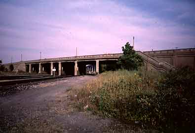
Fort Street Viaduct

Primary Photographer(s): Nathan Holth and Rick McOmber
Bridge Documented: July 1, 2007
Fort Street Over Railroad (Various), Pleasant Street, and Sanders Street
Detroit: Wayne County, Michigan: United States
Not Available or Not Applicable
51.8 Feet (15.8 Meters)
2,800.0 Feet (853.4 Meters)
80 Feet (24.38 Meters)
7 Main Span(s) and 13 Approach Span(s)
82182073000R010

View Information About HSR Ratings
Bridge Documentation
This bridge no longer exists!
View Archived National Bridge Inventory Report - Has Additional Details and Evaluation
This historic bridge was demolished by Michigan Department of Transportation in 2010!
This bridge was quite impressive because it was very large and used a lot of concrete. The approaches were dirt with concrete retaining walls around them. There were spans over Pleasant Street and Sanders Street, and a set of main spans over the railroad tracks. This bridge once had balustrades on the railings which had since been filled in with concrete, which detracted from the beauty this bridge once showed. This was an extremely wide bridge even by modern standards, and it must have been quite the sight back when it was completed. At the time this bridge was built, traffic congestion was becoming an issue, but the idea of the limited access freeway had not come around yet. As a result, roads like Fort Street were turned into very large surface roads to try to handle the large volumes of traffic, and were called superhighways. The Fort Street Viaduct was designed to hold six lanes! The demolition of this bridge represents a continuation of a trend to demolish anything of heritage value in Detroit from bridges to skyscrapers to baseball stadiums. It is unknown what cost this ignorance of heritage in Detroit will have upon the city's ability to recover from its economic troubles, given that the greater success of other major Midwestern cities, particularly Chicago, includes a strong element of heritage tourism.
Information and Findings From MDOT
The Fort Street Viaduct is eligible for the National Register as an important example of a major urban grade separation built during a formative period of highway development. It is also significant for successfully overcoming the engineering challenges presented by a project of this scale.
|
![]()
Photo Galleries and Videos: Fort Street Viaduct
Bridge Photo-Documentation
A collection of overview and detail photos. This photo gallery contains a combination of Original Size photos and Mobile Optimized photos in a touch-friendly popup viewer.Alternatively, Browse Without Using Viewer
![]()
Maps and Links: Fort Street Viaduct
This historic bridge has been demolished. This map is shown for reference purposes only.
Coordinates (Latitude, Longitude):
Search For Additional Bridge Listings:
Bridgehunter.com: View listed bridges within 0.5 miles (0.8 kilometers) of this bridge.
Bridgehunter.com: View listed bridges within 10 miles (16 kilometers) of this bridge.
Additional Maps:
Google Streetview (If Available)
GeoHack (Additional Links and Coordinates)
Apple Maps (Via DuckDuckGo Search)
Apple Maps (Apple devices only)
Android: Open Location In Your Map or GPS App
Flickr Gallery (Find Nearby Photos)
Wikimedia Commons (Find Nearby Photos)
Directions Via Sygic For Android
Directions Via Sygic For iOS and Android Dolphin Browser
USGS National Map (United States Only)
Historical USGS Topo Maps (United States Only)
Historic Aerials (United States Only)
CalTopo Maps (United States Only)


