We Recommend:
Bach Steel - Experts at historic truss bridge restoration.
BridgeHunter.com Phase 1 is released to the public! - Visit Now
Tompkins Bridge

Primary Photographer(s): Nathan Holth
Bridge Documented: 2006
Tompkins: Jackson County, Michigan: United States
1927 By Builder/Contractor: Walter Toebe Company and Engineer/Design: Michigan State Highway Department
Not Available or Not Applicable
65.0 Feet (19.8 Meters)
65.0 Feet (19.8 Meters)
30 Feet (9.14 Meters)
1 Main Span(s)
38138073000B010

View Information About HSR Ratings
Bridge Documentation
View Archived National Bridge Inventory Report - Has Additional Details and Evaluation
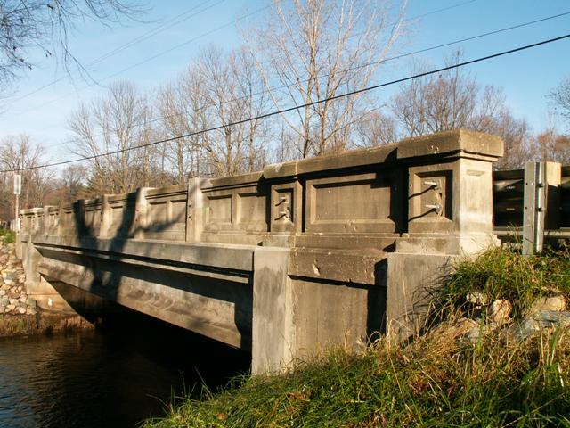
MDOT's website lists this bridge as a concrete-encased deck girder, but it is in fact a concrete-encased steel stringer (multi-beam). The bridge does not feature transverse floorbeams, and instead has a set of parallel beams, therefore it is a multi-beam. The beams on the bridge are not rolled and are built-up (with use of rivets) which adds to the significance of the structure. Perhaps the most noteworthy feature is that the stringers are all encased in concrete. Only the bottom flanges of the beams are visible. Concrete encased stringers were built across the nation in limited quantities as engineers experimented with different designs. Few examples remain today.
This bridge should not be confused with Michigan's more prolific stringer design as seen on bridges like the Chesaning Bridge. Those bridges only feature concrete on the outside of the outermost beam. All other beams on those bridges are not encased.
This bridge was rehabilitated by MDOT because of its historic significance. Although MDOT has demolished more than its share of historic bridges, they have also restored a fair number of bridges, setting themselves above Michigan's county road commissions in terms of historic bridge success stories.
Information and Findings From Michigan Historic Bridge InventoryNarrative Description
It carries a route that has been important since at least the early
twentieth century. A 1911 atlas shows Clinton Road following the present
path of M-50 through the area. Within six years, the road had been
incorporated into the state trunk highway system; a short length through
the town of Tompkins was designated a reward route. A 62-foot
pin-connected Pratt pony truss with a 16-foot roadway initially carried
the road over Sandstone Creek. Statement of Significance Although steel deck girder structures had been used in the state since the 1900s, the highway department did not issue a concrete-encased design until the 1927-1928 biennium. Despite the addition of modern metal guardrails along the inner faces of the railings, the present bridge serves as a good early example of a state standard plan steel deck-girder bridge. Michigan State Highway 50 Bridge is eligible for the National Register as a well-preserved early example of a steel deck-girder bridge. |
![]()
Photo Galleries and Videos: Tompkins Bridge
Bridge Photo-Documentation
A collection of overview and detail photos. This photo gallery contains a combination of Original Size photos and Mobile Optimized photos in a touch-friendly popup viewer.Alternatively, Browse Without Using Viewer
![]()
Maps and Links: Tompkins Bridge
Coordinates (Latitude, Longitude):
Search For Additional Bridge Listings:
Bridgehunter.com: View listed bridges within 0.5 miles (0.8 kilometers) of this bridge.
Bridgehunter.com: View listed bridges within 10 miles (16 kilometers) of this bridge.
Additional Maps:
Google Streetview (If Available)
GeoHack (Additional Links and Coordinates)
Apple Maps (Via DuckDuckGo Search)
Apple Maps (Apple devices only)
Android: Open Location In Your Map or GPS App
Flickr Gallery (Find Nearby Photos)
Wikimedia Commons (Find Nearby Photos)
Directions Via Sygic For Android
Directions Via Sygic For iOS and Android Dolphin Browser
USGS National Map (United States Only)
Historical USGS Topo Maps (United States Only)
Historic Aerials (United States Only)
CalTopo Maps (United States Only)


