We Recommend:
Bach Steel - Experts at historic truss bridge restoration.
BridgeHunter.com Phase 1 is released to the public! - Visit Now
Pointe Drive Bridge

Primary Photographer(s): Nathan Holth
Bridge Documented: June 20, 2003 - Summer 2007
Rural: St. Clair County, Michigan: United States
1938 By Builder/Contractor: Hill and Belknap and Engineer/Design: Michigan State Highway Department
Not Available or Not Applicable
30.8 Feet (9.4 Meters)
36.0 Feet (11 Meters)
22 Feet (6.71 Meters)
1 Main Span(s)
77310A00013B010

View Information About HSR Ratings
Bridge Documentation
This bridge no longer exists!
View Archived National Bridge Inventory Report - Has Additional Details and Evaluation
This bridge was demolished and replaced in 2014-2015 under Local Bridge Program!
This bridge used to carry M-29, until it was realigned. Now it carries local (and light) traffic down Pointe Drive.
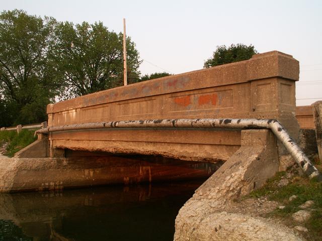
This is a standard plan concrete through girder bridge. A plaque on the bridge identifies it as a trunk line bridge, but does not give a construction date. The Michigan historic bridge inventory gives a date of 1938, which seems like a relatively late construction date for this structure type.
These bridges are a good example of the difference between the way bridges today are built versus the way they were built in the early 20th century. Although a rather utilitarian design, this bridge still manages to be attractive, because someone cared enough to add such simple design to the bridge plan as inset rectangles, other small changes in the shape of the girder, that give the appearance of end posts and such. Since attention is no longer paid to aesthetics in bridge design, these sorts of features are no longer included on today's bridges. When attention is paid in modern bridges, such design usually involves adding decorations to a mundane structure. During the time of bridges such as the Pointe Drive Bridge, the emphasis was instead to make the structure of the bridge itself attractive.
There is no reason to waste taxpayer money on replacing this bridge. This is a residential road now, and if trucks need to get down it, they can bypass the bridge using M-29, whose current alignment is not far from this road. A preserved Pointe Drive Bridge would be more than sufficient for the traffic it carries today.
This bridge is tagged with the following special condition(s): Unorganized Photos
![]()
Photo Galleries and Videos: Pointe Drive Bridge
Bridge Photo-Documentation
A collection of overview and detail photos. This photo gallery contains a combination of Original Size photos and Mobile Optimized photos in a touch-friendly popup viewer.Alternatively, Browse Without Using Viewer
![]()
Additional Unorganized Photos
Original / Full Size PhotosThis photo gallery features older ca. 2003-2006 photos taken when the website only included a few photos in original size on the website, and a smaller quantity of reduced size photos as well. This unorganized gallery may partially duplicate photos in other galleries on this bridge's page, however all photos here are available in the Original / Full Size. This gallery offers photos in the highest available resolution and file size in a touch-friendly popup viewer.
Alternatively, Browse Without Using Viewer
![]()
Additional Unorganized Photos
Mobile Optimized PhotosThis photo gallery features older ca. 2003-2006 photos taken when the website only included a few photos in original size on the website, and a smaller quantity of reduced size photos as well. This unorganized gallery may partially duplicate photos in other galleries on this bridge's page, however all photos here are available in the Original / Full Size. This gallery features data-friendly, fast-loading photos in a touch-friendly popup viewer.
Alternatively, Browse Without Using Viewer
![]()
Maps and Links: Pointe Drive Bridge
This historic bridge has been demolished. This map is shown for reference purposes only.
Coordinates (Latitude, Longitude):
Search For Additional Bridge Listings:
Bridgehunter.com: View listed bridges within 0.5 miles (0.8 kilometers) of this bridge.
Bridgehunter.com: View listed bridges within 10 miles (16 kilometers) of this bridge.
Additional Maps:
Google Streetview (If Available)
GeoHack (Additional Links and Coordinates)
Apple Maps (Via DuckDuckGo Search)
Apple Maps (Apple devices only)
Android: Open Location In Your Map or GPS App
Flickr Gallery (Find Nearby Photos)
Wikimedia Commons (Find Nearby Photos)
Directions Via Sygic For Android
Directions Via Sygic For iOS and Android Dolphin Browser
USGS National Map (United States Only)
Historical USGS Topo Maps (United States Only)
Historic Aerials (United States Only)
CalTopo Maps (United States Only)

