We Recommend:
Bach Steel - Experts at historic truss bridge restoration.
BridgeHunter.com Phase 1 is released to the public! - Visit Now
Sigler Road Bridge

Primary Photographer(s): Nathan Holth
Bridge Documented: August 1, 2005
Rural: Monroe County, Michigan: United States
1954 By Builder/Contractor: Unknown and Engineer/Design: Michigan State Highway Department
Not Available or Not Applicable
77.8 Feet (23.7 Meters)
261.8 Feet (79.8 Meters)
26 Feet (7.92 Meters)
4 Main Span(s)
58158152000S060

View Information About HSR Ratings
Bridge Documentation
View Archived National Bridge Inventory Report - Has Additional Details and Evaluation
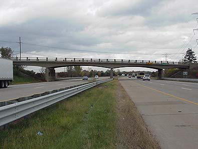
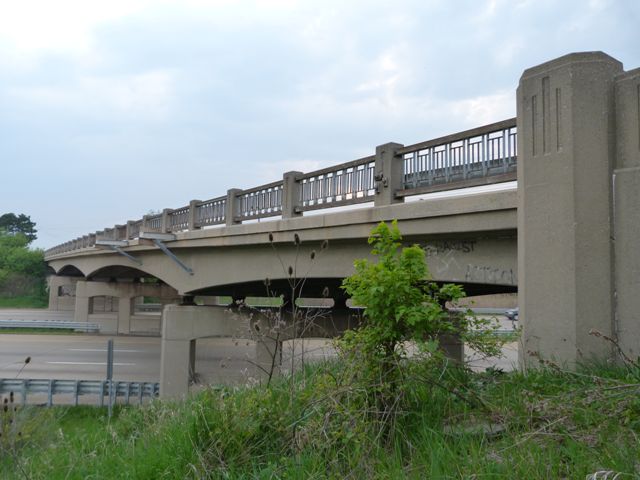
Bridges like the Sigler Road Bridge are not arch bridges, they are t-beam bridges. Specifically, they are known as curved t-beams, or arched t-beams. These bridges have arch shapes to them, but they are not the half-circle shaped arches of true arch bridges. Instead, shallow, graceful curves form an attractive arch-like appearance to this bridge. They are a welcome treat after long drives on boring expressway.
This bridge was built in 1954, and was built two years before I-75 opened in the area, according to MDOT. The Sigler Road Bridge retains excellent integrity, with the exception of missing plaques. A total of six parallel t-beams make up the width of this four span bridge.
Small, isolated populations of these can be found on older sections of expressways in Michigan in several places, including I-69 west of Flint, and I-94 west of I-69 in southwest Michigan, and I-96 around Portland. I-75 has a few sections, including the area around Monroe, which is where Sigler Road is. They can also be found north of Saginaw, and south of the Mackinac Bridge. Very few however retain their original guardrails, which is what makes Sigler Road, as well as several other nearby I-75 bridges near Monroe special. The guardrails, which are an old standard plan guardrail seen on bridges built in the 1940s and 1950s, are after the arched shape the second most important thing that makes these bridges beautiful.
Of the remaining bridges of this type on I-75, this is the only one that retains original railings with no modern Armco guardrails added.
Information and Findings From MDOTThe four-span Sigler Road Bridge crosses six lanes of I-75 and a median. Piers are concrete with three arched openings. The two-lane-wide deck is carried by six T-beams. The structure is located in a rural area a few miles south of the Wayne County line. Built in 1954, this structure was one of several grade separations constructed in Monroe County for the Detroit-Toledo Expressway. The contract price for this bridge project was $137,610.93. The new expressway was part of the state highway department's emphasis on trunkline improvement and expressway development in the period which followed World War II. The Detroit-Toledo Expressway was not the first important north-south road to traverse the eastern section of Monroe County. The Dixie Highway became the first highway in Michigan in 1829. This dirt road had long been an Indian trail. Located essentially parallel to the current I-75, the Dixie Highway was the main route between Detroit and Toledo until the early 1920s, when Telegraph Road was built a short distance to its west. Both roads are still in use, but have mainly carried local traffic since the opening of I-75 in 1956. It was hoped that the new expressway would relieve some of the heavy truck traffic clogging Telegraph Road. Although I-75 does not follow exactly the route of either of the earlier roads, the importance of traffic flow through the corridor is evident. Survey work for the new expressway was completed by June 1952, and bridge work on the approximately 25-mile route began during the 1953-54 biennium. The road bed and bridges and grade separations were designed to allow for the future addition of a third traffic lane in each direction. Of the interstate highways being built outside of the Detroit metropolitan area, the routes for I-75 and I-94 (Detroit to Chicago) were the furthest toward completion by the mid-1950s. Along with its importance as an early expressway structure, the Sigler Road Bridge is also structurally significant. The state highway department first issued standard plans for concrete T-beams were being used for greater under-bridge clearance. This structure stands out for its long spans and number of spans, along with the very good historical integrity which has been maintained.
|
![]()
Photo Galleries and Videos: Sigler Road Bridge
2010 Bridge Photo-Documentation
Original / Full Size PhotosA collection of overview and detail photos, taken March 25, 2010. This gallery offers photos in the highest available resolution and file size in a touch-friendly popup viewer.
Alternatively, Browse Without Using Viewer
![]()
2010 Bridge Photo-Documentation
Mobile Optimized PhotosA collection of overview and detail photos, taken March 25, 2010. This gallery features data-friendly, fast-loading photos in a touch-friendly popup viewer.
Alternatively, Browse Without Using Viewer
![]()
2005 Bridge Photo-Documentation
A collection of overview and detail photos, taken August 1 2005. This photo gallery contains a combination of Original Size photos and Mobile Optimized photos in a touch-friendly popup viewer.Alternatively, Browse Without Using Viewer
![]()
Maps and Links: Sigler Road Bridge
Coordinates (Latitude, Longitude):
Search For Additional Bridge Listings:
Bridgehunter.com: View listed bridges within 0.5 miles (0.8 kilometers) of this bridge.
Bridgehunter.com: View listed bridges within 10 miles (16 kilometers) of this bridge.
Additional Maps:
Google Streetview (If Available)
GeoHack (Additional Links and Coordinates)
Apple Maps (Via DuckDuckGo Search)
Apple Maps (Apple devices only)
Android: Open Location In Your Map or GPS App
Flickr Gallery (Find Nearby Photos)
Wikimedia Commons (Find Nearby Photos)
Directions Via Sygic For Android
Directions Via Sygic For iOS and Android Dolphin Browser
USGS National Map (United States Only)
Historical USGS Topo Maps (United States Only)
Historic Aerials (United States Only)
CalTopo Maps (United States Only)


