
View Information About HSR Ratings
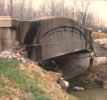
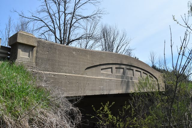
This is the least-deteriorated examples of the curved-chord through girder bridges in St. Clair county in terms of structural integrity. The concrete has not experienced much spalling, which is good. The structure is skewed quite noticeably. The bridge has State Reward Bridge plaques on it. The bridge was built in 1922, which makes it an early and well preserved example of its structure type.
There is no weight limit on this bridge, there are currently no plans to replace it! However, knowing St. Clair County this will not always be the case. It is important that this bridge not be demolished. The time to restore this bridge, perhaps by applying a protective concrete sealant, is now, before the bridge becomes deficient and costs to rehabilitate increase.

Information and Findings From Michigan Historic Bridge InventoryNarrative Description This is the oldest known surviving example of a standard Michigan State Highway Department concrete camelback bridge of 50 feet. Michigan's Department developed standard designs in the late 1910s as a way of producing inexpensive bridges for the State Trunkline System, and was a national leader in doing so. Richard Adler of Port Hope, Michigan, was the bridge contractor.
|
This bridge is tagged with the following special condition(s): Unorganized Photos
![]()

![]()
![]()
![]()
Coordinates (Latitude, Longitude):
Search For Additional Bridge Listings:
Bridgehunter.com: View listed bridges within 0.5 miles (0.8 kilometers) of this bridge.
Bridgehunter.com: View listed bridges within 10 miles (16 kilometers) of this bridge.
Additional Maps:
Google Streetview (If Available)
GeoHack (Additional Links and Coordinates)
Apple Maps (Via DuckDuckGo Search)
Apple Maps (Apple devices only)
Android: Open Location In Your Map or GPS App
Flickr Gallery (Find Nearby Photos)
Wikimedia Commons (Find Nearby Photos)
Directions Via Sygic For Android
Directions Via Sygic For iOS and Android Dolphin Browser
USGS National Map (United States Only)
Historical USGS Topo Maps (United States Only)
Historic Aerials (United States Only)
CalTopo Maps (United States Only)

© Copyright 2003-2026, HistoricBridges.org. All Rights Reserved. Disclaimer: HistoricBridges.org is a volunteer group of private citizens. HistoricBridges.org is NOT a government agency, does not represent or work with any governmental agencies, nor is it in any way associated with any government agency or any non-profit organization. While we strive for accuracy in our factual content, HistoricBridges.org offers no guarantee of accuracy. Information is provided "as is" without warranty of any kind, either expressed or implied. Information could include technical inaccuracies or errors of omission. Opinions and commentary are the opinions of the respective HistoricBridges.org member who made them and do not necessarily represent the views of anyone else, including any outside photographers whose images may appear on the page in which the commentary appears. HistoricBridges.org does not bear any responsibility for any consequences resulting from the use of this or any other HistoricBridges.org information. Owners and users of bridges have the responsibility of correctly following all applicable laws, rules, and regulations, regardless of any HistoricBridges.org information.
![]()