

View Information About HSR Ratings
The Harbin Drive Bridge and the Jefferson Avenue Bridge are two separate structures with different construction dates, but they have been made to have the appearance of a single bridge such as the Hill-To-Hill Bridge. As such, they contribute to each other, and it is impossible to discuss one of these bridges without including the other. This narrative and the accompanying photo gallery discusses and covers both bridges at once. However, the Key Facts, Technical Facts, and NBI Sheet on this page refer to the Harbin Drive Bridge. Switch pages here to view data for the Jefferson Avenue Bridge.
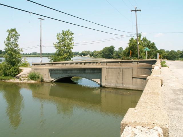
These bridges are interesting because they share a continuous railing, as shown on the above photo. The Harbin Drive Bridge, which is a concrete arch bridge, is actually older than the Jefferson Avenue Bridge, and all the railing on it. The railing, and some of the angling of the bridge was changed to match the Jefferson Avenue Bridge, which was built in 1930. MDOT mentions that the bridges are significant because they are the product of an Assessment District. The plaque on the bridge lists this as well. This is because Huron River forms the county line between Monroe and Wayne County.

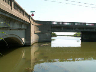
The Harbin Drive Bridge looks quite attractive as an arch bridge, with its 1930 guardrails above. It has a bit of a slope to get up to Jefferson Avenue Bridge. This is probably one of the changes made to Harbin Avenue when Jefferson Avenue Bridge was built. As you approach the bridge from a distance, the dirt approaches for the bridge are clearly visible. The Jefferson Avenue Bridge was given some additional height when built to provide clearance for boats. Indeed, the 1930 bridge replaced a through truss swing bridge (hand-turned), so at the time the river was used for navigation. A photo of the swing bridge existing prior to this bridge is available to the right. Note the endposts of a pony truss approach span are visible to the left in the photo, and a plaque is mounted on top of the portal bracing. However not enough detail of truss or plaque is visible to take a guess on the builder.
The Jefferson Avenue Bridge is a long example of the standard plan 1930s beam bridge style, with three spans. There are no weight limits present on either of the bridges, and the Jefferson Avenue Bridge carries a fair amount of traffic, including a good number of heavy trucks. This has deteriorated the deck a bit, and the trucks, which never seem to slow down, make an awful noise as they speed across the bridge. There should be a reduced speed limit to slow traffic down for safety, as well as for the wellbeing of the bridge.
Information and Findings From Michigan Historic Bridge InventoryNarrative Description The Jefferson Avenue and Harbin Drive Bridges are eligible for the
National Register as an example of an assessment district project. In
addition, the Jefferson Avenue Bridge is eligible as an early long-span
stringer bridge. |
![]()
![]()
![]()

![]()
Coordinates (Latitude, Longitude):
Search For Additional Bridge Listings:
Bridgehunter.com: View listed bridges within 0.5 miles (0.8 kilometers) of this bridge.
Bridgehunter.com: View listed bridges within 10 miles (16 kilometers) of this bridge.
Additional Maps:
Google Streetview (If Available)
GeoHack (Additional Links and Coordinates)
Apple Maps (Via DuckDuckGo Search)
Apple Maps (Apple devices only)
Android: Open Location In Your Map or GPS App
Flickr Gallery (Find Nearby Photos)
Wikimedia Commons (Find Nearby Photos)
Directions Via Sygic For Android
Directions Via Sygic For iOS and Android Dolphin Browser
USGS National Map (United States Only)
Historical USGS Topo Maps (United States Only)
Historic Aerials (United States Only)
CalTopo Maps (United States Only)

© Copyright 2003-2025, HistoricBridges.org. All Rights Reserved. Disclaimer: HistoricBridges.org is a volunteer group of private citizens. HistoricBridges.org is NOT a government agency, does not represent or work with any governmental agencies, nor is it in any way associated with any government agency or any non-profit organization. While we strive for accuracy in our factual content, HistoricBridges.org offers no guarantee of accuracy. Information is provided "as is" without warranty of any kind, either expressed or implied. Information could include technical inaccuracies or errors of omission. Opinions and commentary are the opinions of the respective HistoricBridges.org member who made them and do not necessarily represent the views of anyone else, including any outside photographers whose images may appear on the page in which the commentary appears. HistoricBridges.org does not bear any responsibility for any consequences resulting from the use of this or any other HistoricBridges.org information. Owners and users of bridges have the responsibility of correctly following all applicable laws, rules, and regulations, regardless of any HistoricBridges.org information.
![]()