HistoricBridges.org Menu: HistoricBridges.org Menu:


We Recommend:
Bach Steel - Experts at historic truss bridge restoration.

HistoricBridges.org: Bridge Browser

Michigan Avenue Bridge

Michigan Avenue Bridge

Primary Photographer(s): Nathan Holth

Bridge Documented: Spring 2007

View Photos
and Videos
View Maps
and Links

Facility Carried / Feature Intersected
Michigan Avenue Over Rice Creek
Location
Rural (Near Marshall): Calhoun County, Michigan: United States
Structure Type
Concrete Through Girder, Fixed
Construction Date and Builder / Engineer
1923 By Builder/Contractor: B. C. Lord of Clayton, Michigan and Engineer/Design: Michigan State Highway Department
Rehabilitation Date
Not Available or Not Applicable
Main Span Length
50.0 Feet (15.2 Meters)
Structure Length
50.0 Feet (15.2 Meters)
Roadway Width
24 Feet (7.32 Meters)
Spans
1 Main Span(s)
Inventory Number
13200030000B010

Historic Significance Rating (HSR)
View Information About HSR Ratings

Bridge Documentation

This bridge no longer exists!

View Archived National Bridge Inventory Report - Has Additional Details and Evaluation

This bridge was demolished and replaced in 2014 under Local Bridge Program!

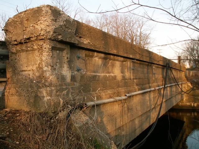
This bridge is one of only two surviving examples of straight concrete through girder bridges in Calhoun County. It retains a plaque on it attributing the building of the bridge to B. C. Lord of Clayton Michigan. The Trunk Line Bridge label on the bridge is testimony to Michigan Avenue's US-12 past. US-12 is currently aligned much further south, replacing the US-112 designation down there for what is often called Chicago Road. This change occurred after I-94 was completed.

Armco railings added to this bridge greatly detract from the beauty of this bridge. This bridge is also suffering from spalling, due to salt application on roadways. It is however one of a rapidly declining historic bridge type in Michigan.


This bridge is tagged with the following special condition(s): Unorganized Photos

Divider

Photo Galleries and Videos: Michigan Avenue Bridge


View Photo Gallery

Bridge Photo-Documentation

A collection of overview and detail photos. This photo gallery contains a combination of Original Size photos and Mobile Optimized photos in a touch-friendly popup viewer.
Alternatively, Browse Without Using Viewer

Divider

View Photo Gallery

Additional Unorganized Photos

Original / Full Size Photos
This photo gallery features older ca. 2003-2006 photos taken when the website only included a few photos in original size on the website, and a smaller quantity of reduced size photos as well. This unorganized gallery may partially duplicate photos in other galleries on this bridge's page, however all photos here are available in the Original / Full Size. This gallery offers photos in the highest available resolution and file size in a touch-friendly popup viewer.
Alternatively, Browse Without Using Viewer

Divider

View Photo Gallery

Additional Unorganized Photos

Mobile Optimized Photos
This photo gallery features older ca. 2003-2006 photos taken when the website only included a few photos in original size on the website, and a smaller quantity of reduced size photos as well. This unorganized gallery may partially duplicate photos in other galleries on this bridge's page, however all photos here are available in the Original / Full Size. This gallery features data-friendly, fast-loading photos in a touch-friendly popup viewer.
Alternatively, Browse Without Using Viewer

Divider

Maps and Links: Michigan Avenue Bridge

This historic bridge has been demolished. This map is shown for reference purposes only.

Coordinates (Latitude, Longitude):

Search For Additional Bridge Listings:

Bridgehunter.com: View listed bridges within 0.5 miles (0.8 kilometers) of this bridge.

Bridgehunter.com: View listed bridges within 10 miles (16 kilometers) of this bridge.

HistoricBridges.org Bridge Browser: View listed bridges within 0.5 miles (0.8 kilometers) of this bridge.

HistoricBridges.org Bridge Browser: View listed bridges within 10 miles (16 kilometers) of this bridge.

2021 National Bridge Inventory: View listed bridges within 0.5 miles (0.8 kilometers) of this bridge.

Additional Maps:

Google Maps

Google Streetview (If Available)

Bing Maps

OpenStreetMap

GeoHack (Additional Links and Coordinates)

Apple Maps (Via DuckDuckGo Search)

Apple Maps (Apple devices only)

MapQuest

HERE We Go Maps

ACME Mapper

Waze Map

Android: Open Location In Your Map or GPS App

Flickr Gallery (Find Nearby Photos)

Wikimedia Commons (Find Nearby Photos)

Directions Via Sygic For Android

Directions Via Sygic For iOS and Android Dolphin Browser

USGS National Map (United States Only)

Historical USGS Topo Maps (United States Only)

Historic Aerials (United States Only)

CalTopo Maps (United States Only)


Divider
 
Home Top

Divider

About - Contact

© Copyright 2003-2024, HistoricBridges.org. All Rights Reserved. Disclaimer: HistoricBridges.org is a volunteer group of private citizens. HistoricBridges.org is NOT a government agency, does not represent or work with any governmental agencies, nor is it in any way associated with any government agency or any non-profit organization. While we strive for accuracy in our factual content, HistoricBridges.org offers no guarantee of accuracy. Information is provided "as is" without warranty of any kind, either expressed or implied. Information could include technical inaccuracies or errors of omission. Opinions and commentary are the opinions of the respective HistoricBridges.org member who made them and do not necessarily represent the views of anyone else, including any outside photographers whose images may appear on the page in which the commentary appears. HistoricBridges.org does not bear any responsibility for any consequences resulting from the use of this or any other HistoricBridges.org information. Owners and users of bridges have the responsibility of correctly following all applicable laws, rules, and regulations, regardless of any HistoricBridges.org information.

Admin Login

Divider