We Recommend:
Bach Steel - Experts at historic truss bridge restoration.
BridgeHunter.com Phase 1 is released to the public! - Visit Now
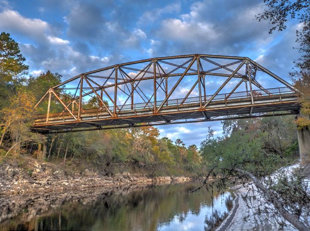
Suwannee Springs Bridge

Primary Photographer(s): Nathan Holth
Bridge Documented: November 16, 2014
Suwannee Springs: Suwannee County, Florida and Hamilton County, Florida: United States
Metal 7 Panel Rivet-Connected Parker Through Truss, Fixed and Approach Spans: Concrete T-Beam, Fixed
1931 By Builder/Contractor: Austin Bridge Company of Dallas, Texas
Not Available or Not Applicable
160.0 Feet (48.8 Meters)
Not Available
Not Available
1 Main Span(s)
Not Applicable

View Information About HSR Ratings
Bridge Documentation
This bridge includes a traditional riveted through truss main span and a long series of concrete t-beam approach spans at the eastern end of the bridge. The bridge was bypassed and abandoned in 1971, but remains accessible for pedestrians. The bridge retains good historic integrity. Original metal railings remain on the truss spans, and original concrete railings on the t-beam spans.
Given span length is an estimate.
The descendent of the company that built this bridge remains in business as Austin Bridge and Road. Their official website provides the following company history:
Austin Industries was founded by Charles. R. Moore in 1918. But the Austin name first became known in the Texas bridge building field when George Austin came to Dallas in 1889 as an agent for the George E. King Bridge Co. of Des Moines, Iowa. His brother, Frank, joined him in 1894, and they formed Austin Brothers Bridge Company. In 1918, Charles Moore purchased the contracting part of the company when the Austin brothers wanted to focus primarily on bridge fabrication. Moore dropped �Brothers� from the name in 1924. The company became known as Austin Bridge Company and Associated Companies until 1974 when the parent company, Austin Industries, was formed. Since then, Austin Industries has continued to enter diverse markets. It entered the commercial construction field in 1975 when Austin Commercial was established. In 1983, Austin Industrial was formed to meet the growing maintenance and construction needs of the petrochemical, power and manufacturing industries. Austin Bridge merged with two other operating companies, Austin Paving and Austin Road, in the late 1980s.
![]()
Photo Galleries and Videos: Suwannee Springs Bridge
Bridge Photo-Documentation
Original / Full Size PhotosA collection of overview and detail photos. This gallery offers photos in the highest available resolution and file size in a touch-friendly popup viewer.
Alternatively, Browse Without Using Viewer
![]()
Bridge Photo-Documentation
Mobile Optimized PhotosA collection of overview and detail photos. This gallery features data-friendly, fast-loading photos in a touch-friendly popup viewer.
Alternatively, Browse Without Using Viewer
![]()
Maps and Links: Suwannee Springs Bridge
Coordinates (Latitude, Longitude):
Search For Additional Bridge Listings:
Bridgehunter.com: View listed bridges within 0.5 miles (0.8 kilometers) of this bridge.
Bridgehunter.com: View listed bridges within 10 miles (16 kilometers) of this bridge.
Additional Maps:
Google Streetview (If Available)
GeoHack (Additional Links and Coordinates)
Apple Maps (Via DuckDuckGo Search)
Apple Maps (Apple devices only)
Android: Open Location In Your Map or GPS App
Flickr Gallery (Find Nearby Photos)
Wikimedia Commons (Find Nearby Photos)
Directions Via Sygic For Android
Directions Via Sygic For iOS and Android Dolphin Browser
USGS National Map (United States Only)
Historical USGS Topo Maps (United States Only)
Historic Aerials (United States Only)
CalTopo Maps (United States Only)

