

View Information About HSR Ratings
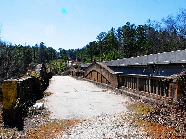
This bridge is the only known example of a curved chord through girder bridge in Georgia. The rare bridge type only appears in a very small number of states. Only Michigan and Ohio are known to have built the bridge type in substantial quantities. The few other states that have any examples usually have less than a handful. Only Michigan appears to have frequently built spans beyond 60 feet in length. In general, concrete through girder bridges of any type rarely exceeded 60 feet. Thus, this Georgia example with 62 foot spans is an example of a long span concrete girder. The bridge has additional significance as a multi-span bridge. An unusual detail is that between the two curved girder spans is a small concrete t-beam span. It is unusual for a shorter span of a bridge to be placed in between two larger spans. More common is the two additional short t-beam spans which are also present at each end of the bridge.
The girder spans have articulated floor beams visible under the deck. The girders also function as railings for the bridge, while the t-beam spans have a simple concrete balustrade railing.
This bridge has been bypassed by a modern bridge but fortunately the historic bridge was left standing next to its replacement.
![]()
![]()
![]()
Coordinates (Latitude, Longitude):
Search For Additional Bridge Listings:
Bridgehunter.com: View listed bridges within 0.5 miles (0.8 kilometers) of this bridge.
Bridgehunter.com: View listed bridges within 10 miles (16 kilometers) of this bridge.
Additional Maps:
Google Streetview (If Available)
GeoHack (Additional Links and Coordinates)
Apple Maps (Via DuckDuckGo Search)
Apple Maps (Apple devices only)
Android: Open Location In Your Map or GPS App
Flickr Gallery (Find Nearby Photos)
Wikimedia Commons (Find Nearby Photos)
Directions Via Sygic For Android
Directions Via Sygic For iOS and Android Dolphin Browser
USGS National Map (United States Only)
Historical USGS Topo Maps (United States Only)
Historic Aerials (United States Only)
CalTopo Maps (United States Only)

© Copyright 2003-2026, HistoricBridges.org. All Rights Reserved. Disclaimer: HistoricBridges.org is a volunteer group of private citizens. HistoricBridges.org is NOT a government agency, does not represent or work with any governmental agencies, nor is it in any way associated with any government agency or any non-profit organization. While we strive for accuracy in our factual content, HistoricBridges.org offers no guarantee of accuracy. Information is provided "as is" without warranty of any kind, either expressed or implied. Information could include technical inaccuracies or errors of omission. Opinions and commentary are the opinions of the respective HistoricBridges.org member who made them and do not necessarily represent the views of anyone else, including any outside photographers whose images may appear on the page in which the commentary appears. HistoricBridges.org does not bear any responsibility for any consequences resulting from the use of this or any other HistoricBridges.org information. Owners and users of bridges have the responsibility of correctly following all applicable laws, rules, and regulations, regardless of any HistoricBridges.org information.
![]()