We Recommend:
Bach Steel - Experts at historic truss bridge restoration.
BridgeHunter.com Phase 1 is released to the public! - Visit Now
Savannah Footbridge Middle

Primary Photographer(s): Nathan Holth
Bridge Documented: November 14, 2014
Savannah: Chatham County, Georgia: United States
By Builder/Contractor: Unknown
Not Available or Not Applicable
Not Available
Not Available
Not Available
1 Main Span(s)
Not Applicable

View Information About HSR Ratings
Bridge Documentation
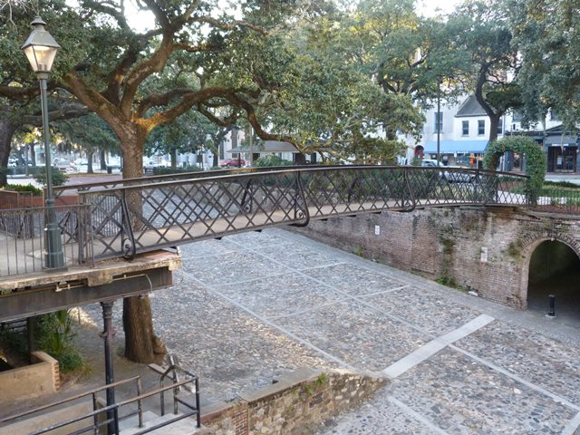
Savannah has three historic riveted lattice girder bridges, and one modern, non-historic welded lattice girder that carry pedestrians over the roadways between Bay Street and River Street. This is one of those three genuine historic bridges. Two of the historic lattice girder bridges are through girders, where the load-bearing lattice girder also serves as a railing, while the third historic lattice girder bridge is a deck girder. This is one of the through lattice girder bridges. Lattice girder bridges of any kind are a bridge type that is almost unheard of in the United States, and are far more common in Europe. These bridges in Savannah are therefore significant as a rare example of this European style bridge in the United States.
Sadly, very little is known about these three bridges, including who built them and when they date to.
The look of this bridge, especially with the curved outriggers it displays, is very reminiscent of lattice girder bridges found in the United Kingdom, where they were erected at train stations as pedestrian grade separations, allowing people to walk over the railway. An example can be seen here.
At the north end, the bridge leads to a walkway, which near the bridge is supported by a beautiful cast iron column. The beam resting on the column has a Jones and Laughlin brand (not "Laughlins") indicating the beam dates to after the 1905 Laughlin name change. The beam, one would assume, is likely newer than both bridge and column.
What makes this bridge a "lattice girder" and not a lattice truss with Quadruple Intersection Warren configuration? This could be open for debate, but in general bridges classified as lattice girder bridges instead of trusses have a very simple design and the actual size of the girder/truss is not large. Thus, these bridges in Savannah with a lattice composed of simple bars, and a depth of girder no higher than a standard pedestrian railing, clearly fall in the lattice girder category, especially when looking at how similar bridges in Europe are described.
![]()
Photo Galleries and Videos: Savannah Footbridge Middle
Bridge Photo-Documentation
Original / Full Size PhotosA collection of overview and detail photos. This gallery offers photos in the highest available resolution and file size in a touch-friendly popup viewer.
Alternatively, Browse Without Using Viewer
![]()
Bridge Photo-Documentation
Mobile Optimized PhotosA collection of overview and detail photos. This gallery features data-friendly, fast-loading photos in a touch-friendly popup viewer.
Alternatively, Browse Without Using Viewer
![]()
Maps and Links: Savannah Footbridge Middle
Coordinates (Latitude, Longitude):
Search For Additional Bridge Listings:
Bridgehunter.com: View listed bridges within 0.5 miles (0.8 kilometers) of this bridge.
Bridgehunter.com: View listed bridges within 10 miles (16 kilometers) of this bridge.
Additional Maps:
Google Streetview (If Available)
GeoHack (Additional Links and Coordinates)
Apple Maps (Via DuckDuckGo Search)
Apple Maps (Apple devices only)
Android: Open Location In Your Map or GPS App
Flickr Gallery (Find Nearby Photos)
Wikimedia Commons (Find Nearby Photos)
Directions Via Sygic For Android
Directions Via Sygic For iOS and Android Dolphin Browser
USGS National Map (United States Only)
Historical USGS Topo Maps (United States Only)
Historic Aerials (United States Only)
CalTopo Maps (United States Only)

