We Recommend:
Bach Steel - Experts at historic truss bridge restoration.
BridgeHunter.com Phase 1 is released to the public! - Visit Now
18th Street Bridge
Primary Photographer(s): Nathan Holth
Bridge Documented: October 2010, May 2012
Chicago: Cook County, Illinois: United States
Metal Rivet-Connected Pratt Railing Height Truss, Movable: Single Leaf Bascule (Fixed Trunnion) and Approach Spans: Metal Stringer (Multi-Beam), Fixed
1967 By Builder/Contractor: Overland Construction Company of Chicago, Illinois and Engineer/Design: City of Chicago
Not Available or Not Applicable
182.0 Feet (55.5 Meters)
280.0 Feet (85.3 Meters)
48 Feet (14.63 Meters)
1 Main Span(s) and 1 Approach Span(s)
16601727332

View Information About HSR Ratings
Bridge Documentation
This Youtube video from the 1930s shows the former 18th Street Bridge briefly: https://youtu.be/tpE_hyUtbA8?si=lNDiy6i8qwVVupob&t=247
View Archived National Bridge Inventory Report - Has Additional Details and Evaluation
2015 Rehabilitation
This bridge is slated for rehabilitation to run from December 2014 to April 2015 at a cost of $5.4 Million. The work is to include new roadway deck and sidewalk deck, truss repairs, and unspecified repairs to the floorbeams and lateral bracing.
About This Bridge
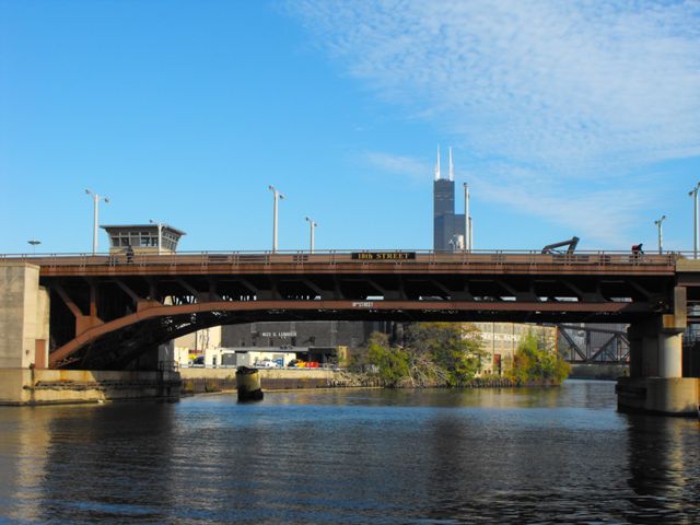
This bridge is a single leaf bascule bridge in Chicago, which is far less common in the city than the double-leaf bascule. Most single-leaf bascule bridges in Chicago are railroad bridges, and as such the 18th Street Bridge is one of only a few single leaf highway bascule bridges. This bridge is also the only single leaf example of Chicago's unique truss bascule design which the qualities of a pony truss and a deck truss, called a railing height truss. This was an innovative design that kept the majority of the truss below the deck in an attractive polygonal arch-like shape. At the same time, the top chord was located above the deck to function as a railing and increase the below-deck clearance for the bridge while also creating a slimmer profile for the bridge's appearance. With a 1967 construction date, the 18th Street Bridge is one of the youngest of Chicago's historic bridges. HistoricBridges.org considers all bascule bridges in Chicago constructed before 1970 to have at least some level of historic significance and value. The bridge retains good historic integrity and appears largely unaltered. A long viaduct of simple stringer spans provide an approach to this bridge. This viaduct system is not included as part of the bridge proper and so the lengths of these viaducts are not included in the technical facts table on this bridge page. A plaque on the bascule bridge relates a variety of information including that this is the fourth bridge at this location, however the plaque fails to list the contractors for the construction of the bridge. Despite its young age, the bascule bridge remains noteworthy for its single leaf configuration. The bridge as well as the viaduct approach system all cost $6,700,000. The project began on January 27, 1965 and the bridge opened to traffic on August 17, 1967, with all work totally completed by December 12, 1967.
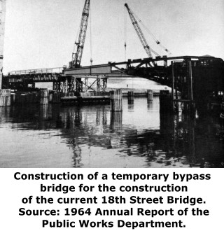
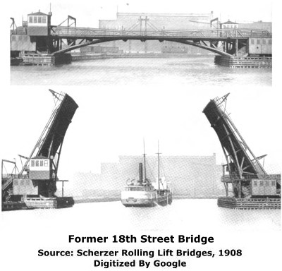
The first documented bridge at this location was built in 1868 by Fox and Howard and was a combination iron/wood swing bridge and was hand-turned. The King Bridge Company of Cleveland, Ohio replaced the bridge with an iron and steel swing bridge (also hand turned) in 1888. The bridge was again replaced, this time in 1905 with a steel Scherzer Rolling Lift bascule bridge built by Jackson and Corbett Company. The previous 1888 bridge was moved and reused at South Western Avenue.
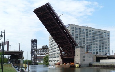
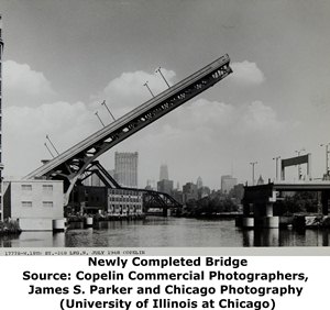
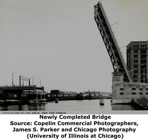
Above: Photos of the bridge shortly after completion, with the bridge in a raised position.
Above: These photos show the elaborate through truss approach viaduct that preceded the current bridge.
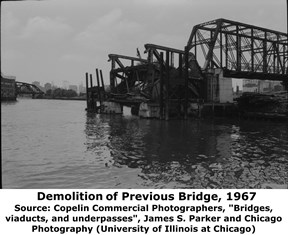
Above: This photo shows the demolition of the previous bascule bridge, with the previous approach viaduct still standing to the right. The downtown skyline can be seen in the background, as well as the two railroad bridges in the background.
|
Main Plaque W. 18TH STREETBRIDGE FOURTH AT THIS SITE --- 1967 --- CITY OF CHICAGO RICHARD J. DALEY MAYOR MILTON PIKARSKY Commissioner of Public Works WALTER E. RASMUS Chief Engineer HARRY ZALEWSKI Asst. Chief Engineer Constn.
|
![]()
Historic Bridges of Chicago and Cook County


Chicago and Cook County are home to one of the largest collections of historic bridges in the country, and no other city in the world has more movable bridges. HistoricBridges.org is proud to offer the most extensive coverage of historic Chicago bridges on the Internet.
General Chicago / Cook County Bridge Resources
Chicago's Bridges - By Nathan Holth, author of HistoricBridges.org, this book provides a discussion of the history of Chicago's movable bridges, and includes a virtual tour discussing all movable bridges remaining in Chicago today. Despite this broad coverage, the book is presented in a compact format that is easy to take with you and carry around for reference on a visit to Chicago. The book includes dozens of full color photos. Only $9.95 U.S! ($11.95 Canadian). Order on Amazon.
Chicago River Bridges - By Patrick T. McBriarty, this is a great companion to Holth's book shown above. This much larger book offers an extremely in-depth exploration of Chicago's movable highway bridges, including many crossings that have not existed for many years. Order Now Direct From The Publisher! or order on Amazon.
View Historic American Engineering Record (HAER) Overview of Chicago Bascule Bridges (HAER Data Pages, PDF)
Chicago Loop Bridges - Chicago Loop Bridges is another website on the Internet that is a great companion to the HistoricBridges.org coverage of the 18 movable bridges within the Chicago Loop. This website includes additional information such as connections to popular culture, overview discussions and essays about Chicago's movable bridges, additional videos, and current news and events relating to the bridges.
Additional Online Articles and Resources - This page is a large gathering of interesting articles and resources that HistoricBridges.org has uncovered during research, but which were not specific to a particular bridge listing.
![]()
Photo Galleries and Videos: 18th Street Bridge
Bridge Photo-Documentation
Original / Full Size PhotosA collection of overview and detail photos. This gallery offers photos in the highest available resolution and file size in a touch-friendly popup viewer.
Alternatively, Browse Without Using Viewer
![]()
Bridge Photo-Documentation
Mobile Optimized PhotosA collection of overview and detail photos. This gallery features data-friendly, fast-loading photos in a touch-friendly popup viewer.
Alternatively, Browse Without Using Viewer
![]()
Bridge Being Raised
Full Motion VideoStreaming video of the bridge. Also includes a higher quality downloadable video for greater clarity or offline viewing.
![]()
Bridge Being Lowered
Full Motion VideoStreaming video of the bridge. Also includes a higher quality downloadable video for greater clarity or offline viewing.
![]()
Maps and Links: 18th Street Bridge
Coordinates (Latitude, Longitude):
Search For Additional Bridge Listings:
Bridgehunter.com: View listed bridges within 0.5 miles (0.8 kilometers) of this bridge.
Bridgehunter.com: View listed bridges within 10 miles (16 kilometers) of this bridge.
Additional Maps:
Google Streetview (If Available)
GeoHack (Additional Links and Coordinates)
Apple Maps (Via DuckDuckGo Search)
Apple Maps (Apple devices only)
Android: Open Location In Your Map or GPS App
Flickr Gallery (Find Nearby Photos)
Wikimedia Commons (Find Nearby Photos)
Directions Via Sygic For Android
Directions Via Sygic For iOS and Android Dolphin Browser
USGS National Map (United States Only)
Historical USGS Topo Maps (United States Only)
Historic Aerials (United States Only)
CalTopo Maps (United States Only)

