We Recommend:
Bach Steel - Experts at historic truss bridge restoration.
BridgeHunter.com Phase 1 is released to the public! - Visit Now
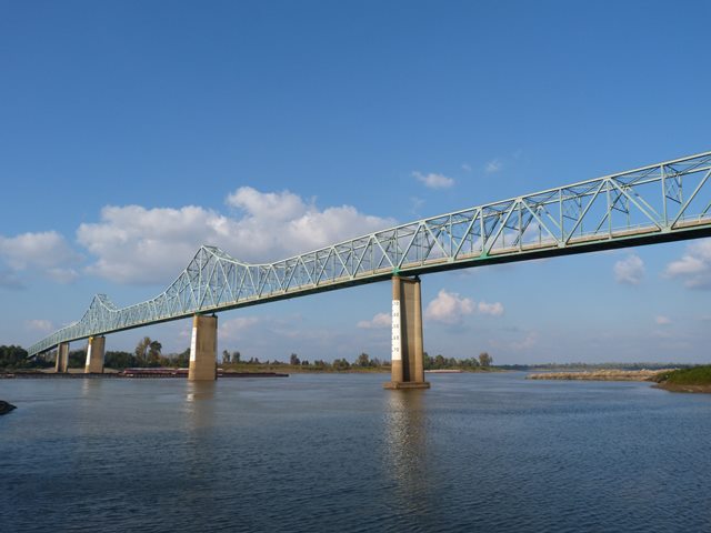
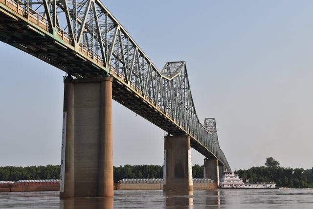
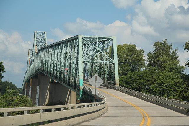
Cairo Mississippi River Bridge
Birds Point Bridge

Primary Photographer(s): Nathan Holth and Rick McOmber
Bridge Documented: November 2, 2013, July 4, 2021, and August 29, 2021
Cairo and Birds Point: Alexander County, Illinois and Mississippi County, Missouri: United States
Metal Cantilever 22 Panel Rivet-Connected Warren Through Truss, Fixed and Approach Spans: Metal Stringer (Multi-Beam), Fixed
1929 By Builder/Contractor: American Bridge Company of New York, New York and Engineer/Design: Waddell and Hardesty of New York, New York
2011
700.0 Feet (213.4 Meters)
5,181.7 Feet (1579.4 Meters)
20 Feet (6.1 Meters)
7 Main Span(s) and 34 Approach Span(s)
6006

View Information About HSR Ratings
Bridge Documentation
This bridge's song is:
View Archived National Bridge Inventory Report - Has Additional Details and Evaluation
At this special point, where two mighty rivers meet, the Ohio and the Mississippi, a truly unique historic bridge presentation is also present, with one historic cantilever truss going over the Mississippi River and another cantilever truss of considerably different appearance crossing the Ohio River. View the other bridge's page. Given the staggering rate in which cantilever truss bridges in the United States (which were never overly populous to begin with) are being demolished, the historic significance and rarity of these two bridges is rapidly increasing.
This bridge has a traditional span composition of a two tower cantilever through truss system over the river. What is more unusual is that a cantilevered through truss system continues over a number of spans beyond the main three cantilever spans. It does this in a way such that these additional through truss spans have horizontal top chords, giving the bridge a unique appearance like a tunnel or tube leading to the largest three spans of the bridge which have two towers like a traditional cantilever truss.
The bridge's center span includes a suspended span that is eight panels and about 254 feet in length. The overall length of the center span is 700 feet.
During the first visit to this bridge, HistoricBridges.org took mainly overview photos and videos of this bridge. A walkthrough for capturing detail photos was later conducted in 2021 in the early morning hours for safety reasons, before the heavy truck traffic increased on this very narrow bridge. Between these two galleries, a complete photo-documentation of this fascinating bridge is now available.
Information and Findings From Missouri's Historic Bridge InventoryBridge Features superstructure: steel, rigid-connected cantilevered through truss; 21 plate girder approach spans on Illinois side; 13 plate girder approach spans on Missouri side substructure: concrete abutments, wingwalls and piers floor/decking : asphalt/ concrete deck over steel stringers Alterations: deck replaced, 1981 Other Features: upper chord and inclined end post: 2 channels with cover plate and double lacing; lower chord: 2 channels with lacing, top and bottom; vertical: 4 angles with lacing ( 4 angles with continuous plate at some points); diagonal: 2 channels with double lacing; lateral bracing: 4 angles with lacing - top, 2 angles - bottom; strut: 2 angles with lacing and "X" bracing; portal strut: 2 angles with lacing; floor beam: plate girder; guardrail: 3 channels; Missouri approach bridge plate: American Bridge Co. USA 1928 Erection Cost: $3,109,311.86 Discussion of Bridge Cairo, Illinois, located at the confluence of the Mississippi and Ohio rivers, was faced with the problem of bridging not one, but two, major rivers to link with outlying areas. A railroad bridge over the Ohio was completed in October 1889 by the Illinois Central Railroad. Consisting of a series of pinned Whipple through trusses, supported by stone piers, it was the longest metallic bridge in the world when completed, and its 518-foot channel spans represented the ultimate extension of the Whipple truss. A vehicular bridge was a long time coming, however. While ferryboats carried wagons and cars across the two rivers, the citizens of Cairo hopefully promoted a single structure with a Y-shaped configuration, with one leg over the Mississippi and one over the Ohio. The structure would be paid for by the government, and its construction and maintenance costs would be defrayed by tolls. When the government was not forthcoming with the funds in the 1920s, the community instead turned to Harry E. Bovay, an Arkansas capitalist. Bovay had built one successful toll bridge in his home state, and he was looking for a larger bridge project, when he contacted the Cairo Chamber of Commerce. Under Bovay's direction, an organization was established to promote the bridge, a Congressional charter was secured, bonds were sold, and the venerable J.A.L. Waddell, of Waddell and Hardesty, was commissioned to design it. The contract for the substructure was awarded to the Missouri Valley Bridge and Iron Company of Leavenworth, Kansas, a veteran of several Mississippi and Missouri River bridge projects. The silicon steel superstructure was to be fabricated and erected by the American Bridge Company of New York. Work on the piers began in July 1927. The channel piers were sunk with agonizing tedium by means of pneumatic caissons. Work on the cantilever spans began in 1928. "The steel work progressed much faster than the foundation work," reported the Cairo Evening Citizen. "You could almost see the bridge creep across the river. The span was cantilevered out over the water half way to the next pier, and a support was put in, resting upon a cluster of piles and the rest of the distance was jumped .... There was no long stretch of piling filling the entire span, as in the construction of the Illinois Central bridge. The method of construction showed the progress made in bridge building between 1887 and 1927, forty years." After several weather-related delays, the trusses were completed and the bridge opened ceremoniously in October 1929. The original Cairo Bridge and Terminal Company operated it as a toll structure until the Cairo Bridge Commission acquired it in 1942. This quasi-public agency held the bridge until the bonds were retired in May 1954 and it was turned over to the states of Missouri and Illinois. The original deck was replaced in 1981, but the Birds Point Bridge remains otherwise intact as a pivotal interstate crossing. Almost a mile long, the Cairo was a stunning achievement for the citizens in southern Illinois and the bootheel of Missouri - the fulfillment of some forty years of boosting. It played a critical role in transportation and commerce in a three-state region, as it linked Cairo with Missouri and Kentucky. The bridge is noteworthy as a superlative example of long-span truss construction. With its 700- foot, silicon steel spans, it is the longest of Missouri's cantilevered through trusses - a historically and technologically significant highway-related resource. Bridge Considered Historic By Survey: Yes |
This bridge is tagged with the following special condition(s): Unorganized Photos
![]()
Photo Galleries and Videos: Cairo Mississippi River Bridge
2021 Bridge Photo-Documentation
Original / Full Size PhotosA collection of overview and detail photos. This gallery offers photos in the highest available resolution and file size in a touch-friendly popup viewer.
Alternatively, Browse Without Using Viewer
![]()
2021 Bridge Photo-Documentation
Mobile Optimized PhotosA collection of overview and detail photos. This gallery features data-friendly, fast-loading photos in a touch-friendly popup viewer.
Alternatively, Browse Without Using Viewer
![]()
Additional Earlier Photo-Documentation
Original / Full Size PhotosA collection of overview and detail photos. This gallery offers photos in the highest available resolution and file size in a touch-friendly popup viewer.
Alternatively, Browse Without Using Viewer
![]()
Additional Earlier Photo-Documentation
Mobile Optimized PhotosA collection of overview and detail photos. This gallery features data-friendly, fast-loading photos in a touch-friendly popup viewer.
Alternatively, Browse Without Using Viewer
![]()
Additional Unorganized Photos
Original / Full Size PhotosA supplemental collection of photos that are from additional visit(s) to the bridge and have not been organized or captioned. This gallery offers photos in the highest available resolution and file size in a touch-friendly popup viewer.
Alternatively, Browse Without Using Viewer
![]()
Additional Unorganized Photos
Mobile Optimized PhotosA supplemental collection of photos that are from additional visit(s) to the bridge and have not been organized or captioned. This gallery features data-friendly, fast-loading photos in a touch-friendly popup viewer.
Alternatively, Browse Without Using Viewer
![]()
CarCam: Southbound Crossing
Full Motion VideoNote: The downloadable high quality version of this video (available on the video page) is well worth the download since it offers excellent 1080 HD detail and is vastly more impressive than the compressed streaming video. Streaming video of the bridge. Also includes a higher quality downloadable video for greater clarity or offline viewing.
![]()
CarCam: Northbound Crossing
Full Motion VideoNote: The downloadable high quality version of this video (available on the video page) is well worth the download since it offers excellent 1080 HD detail and is vastly more impressive than the compressed streaming video. Streaming video of the bridge. Also includes a higher quality downloadable video for greater clarity or offline viewing.
![]()
Maps and Links: Cairo Mississippi River Bridge
Coordinates (Latitude, Longitude):
Search For Additional Bridge Listings:
Bridgehunter.com: View listed bridges within 0.5 miles (0.8 kilometers) of this bridge.
Bridgehunter.com: View listed bridges within 10 miles (16 kilometers) of this bridge.
Additional Maps:
Google Streetview (If Available)
GeoHack (Additional Links and Coordinates)
Apple Maps (Via DuckDuckGo Search)
Apple Maps (Apple devices only)
Android: Open Location In Your Map or GPS App
Flickr Gallery (Find Nearby Photos)
Wikimedia Commons (Find Nearby Photos)
Directions Via Sygic For Android
Directions Via Sygic For iOS and Android Dolphin Browser
USGS National Map (United States Only)
Historical USGS Topo Maps (United States Only)
Historic Aerials (United States Only)
CalTopo Maps (United States Only)


