

View Information About HSR Ratings

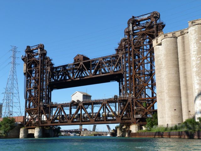
The bridges are currently Norfolk Southern owned. There used to be two of the Pittsburgh, Fort Wayne & Chicago Railway Bridge also but one was demolished in 1965. The Pittsburgh, Fort Wayne & Chicago Railroad bridge is the one that is in the lowered position in the photos. The two that are in the up position are the abandoned Lakeshore and Michigan Southern railroad bridges.
When traveling on one of the many Amtrak trains that cross this bridge, a plaque is visible on the end post of the Pittsburgh, Fort Wayne & Chicago Railway Bridge. John Muntean sent a clear photo of the plaque, which can be found in the photo gallery. The plaque identifies the bridge as a Waddell and Harrington Lift Bridge and lists the Pennsylvania Steel Company as the builder. There may be more plaques on the other bridges. If anyone knows of more plaques on these bridges, Contact us!

In mid-February 2012 an unusual repair project took place for a portion of the bridge that remains in use by trains, the Pittsburgh, Fort Wayne & Chicago Railroad Bridge. A problem was found with the shaft that holds one of the large wheel-shaped cable drums in place at the top of the towers. The cable drum is four feet in width and weighs 60,000 pounds. The repair project was designed to repair the shaft. A portion of the project was limited to 112 hours by the Coast Guard. The Coast Guard typically has very strict restrictions on how long navigation can be obstructed on waterways under its jurisdiction, like the Calumet River. An estimated one week crane rental was needed to complete the project, needed to remove the cable drum and ship it to a shop to be repaired.
Also, one of the cable drums was completely replaced, and the original drum was found laying in a railroad yard just over the state line in Indiana.
Historic American Engineering Record feels that these bridges are the most notable and central railroading symbol for Chicago, the railroad capital of North America.
Next to this bridge is the remains of a Strauss bascule bridge. This bridge has a separate webpage located here.
Thanks to Tom Winkle for providing boat transportation to assist in the photo-documentation of this historic bridge.

|
Additional Technical Facts (Lakeshore and Michigan Southern Bridges) |
|
Construction Date |
Main Span Length | Tower Height | Bridge Width | Skew Amount | Designer |
| 1912-1915 | 209.75 Feet | Aprox. 190 Feet above water level. | 31 Feet Each | 50 Degrees | Waddell and Harrington of Kansas City, Missouri |
|
Additional Technical Facts (Pittsburgh, Fort Wayne & Chicago Railway Bridge) |
|
Construction Date |
Main Span Length | Tower Height | Bridge Width | Skew Amount | Designer | Fabricator | Superstructure Contractor | Substructure Contractor |
| 1912-1913 | 210 Feet | Aprox. 190 Feet above water level. | 31.25 Feet | 50 Degrees | Waddell and Harrington of Kansas City, Missouri | Pennsylvania Steel Company, of Steelton, PA | Kelly-Atkinson Company of Chicago, IL | Dravo Contracting Company of Pittsburgh, PA |

|
Pittsburgh, Fort Wayne, and Chicago Railroad Bridge Plaque WADDELL & HARRINGTON LIFT BRIDGEPATENTED IN U.S.A., AUG 24, 1909. MAR. 22, 1910, MAR 29, 1910, MAY 31, 1911. OTHER PATENTS PENDING PATENTED IN CANADA FEBRUARY 1, 1910, MAR 8, 1910 BUILT BY PENNSYLVANIA STEEL CO. STEELTON, PA. 1912 |
Information and Findings From Chicago Landmarks DesignationGeneral Information Address: East of Chicago Skyway, North of 98th St.
(Calumet River) These Bridges Are Designated Chicago Landmarks |
![]()


Chicago and Cook County are home to one of the largest collections of historic bridges in the country, and no other city in the world has more movable bridges. HistoricBridges.org is proud to offer the most extensive coverage of historic Chicago bridges on the Internet.
General Chicago / Cook County Bridge Resources
Chicago's Bridges - By Nathan Holth, author of HistoricBridges.org, this book provides a discussion of the history of Chicago's movable bridges, and includes a virtual tour discussing all movable bridges remaining in Chicago today. Despite this broad coverage, the book is presented in a compact format that is easy to take with you and carry around for reference on a visit to Chicago. The book includes dozens of full color photos. Only $9.95 U.S! ($11.95 Canadian). Order on Amazon.
Chicago River Bridges - By Patrick T. McBriarty, this is a great companion to Holth's book shown above. This much larger book offers an extremely in-depth exploration of Chicago's movable highway bridges, including many crossings that have not existed for many years. Order Now Direct From The Publisher! or order on Amazon.
View Historic American Engineering Record (HAER) Overview of Chicago Bascule Bridges (HAER Data Pages, PDF)
Chicago Loop Bridges - Chicago Loop Bridges is another website on the Internet that is a great companion to the HistoricBridges.org coverage of the 18 movable bridges within the Chicago Loop. This website includes additional information such as connections to popular culture, overview discussions and essays about Chicago's movable bridges, additional videos, and current news and events relating to the bridges.
Additional Online Articles and Resources - This page is a large gathering of interesting articles and resources that HistoricBridges.org has uncovered during research, but which were not specific to a particular bridge listing.
![]()
![]()
![]()

![]()
![]()
Coordinates (Latitude, Longitude):
Search For Additional Bridge Listings:
Bridgehunter.com: View listed bridges within 0.5 miles (0.8 kilometers) of this bridge.
Bridgehunter.com: View listed bridges within 10 miles (16 kilometers) of this bridge.
Additional Maps:
Google Streetview (If Available)
GeoHack (Additional Links and Coordinates)
Apple Maps (Via DuckDuckGo Search)
Apple Maps (Apple devices only)
Android: Open Location In Your Map or GPS App
Flickr Gallery (Find Nearby Photos)
Wikimedia Commons (Find Nearby Photos)
Directions Via Sygic For Android
Directions Via Sygic For iOS and Android Dolphin Browser
USGS National Map (United States Only)
Historical USGS Topo Maps (United States Only)
Historic Aerials (United States Only)
CalTopo Maps (United States Only)

© Copyright 2003-2026, HistoricBridges.org. All Rights Reserved. Disclaimer: HistoricBridges.org is a volunteer group of private citizens. HistoricBridges.org is NOT a government agency, does not represent or work with any governmental agencies, nor is it in any way associated with any government agency or any non-profit organization. While we strive for accuracy in our factual content, HistoricBridges.org offers no guarantee of accuracy. Information is provided "as is" without warranty of any kind, either expressed or implied. Information could include technical inaccuracies or errors of omission. Opinions and commentary are the opinions of the respective HistoricBridges.org member who made them and do not necessarily represent the views of anyone else, including any outside photographers whose images may appear on the page in which the commentary appears. HistoricBridges.org does not bear any responsibility for any consequences resulting from the use of this or any other HistoricBridges.org information. Owners and users of bridges have the responsibility of correctly following all applicable laws, rules, and regulations, regardless of any HistoricBridges.org information.
![]()