

View Information About HSR Ratings

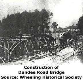
This is a bridge with a long history of alteration and it previously had some mystery attached to it as well, which has since been solved thanks to Pat Barch Hoffman Estate Village Historian and Celeste Kuta, of the Indian Trails Public Library District. Their efforts revealed that the bridge as seen above in a historical photo was built in 1905, and as remarkable as it seems portions of the bridge shown above remain in place, hidden behind under multiple alterations, resulting in the bridge seen today.
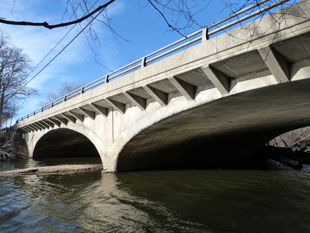
Years ago, when HistoricBridges.org first documented this bridge, it became clear from the field visit alone that this bridge had a story. A plaque on the bridge states that the bridge was "rebuilt" in 1982. Next, a look under the bridge shows that the bridge is a much older concrete arch bridge. The 1982 reconstruction appears to have replaced the deck, while adding cantilevers to the arch to widen the deck. A close look under the arch spans themselves shows that apparently the arch itself was widened long ago as well. Two seams visible under the bridge outline the width of the original arch in the center of the arch's width. Both the original and widened portion of the bridge were poured with the aid of wooden plank forms and the impressions of these planks remain in the concrete, however, the arrangement of the planks for the original part of the arch bridge were arranged differently, as is visible by the impressions.
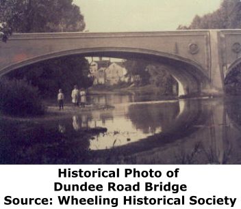
The National Bridge Inventory supplied some additional information into the history of this bridge. It lists a construction date of 1932. However it does not provide information as to whether the 1932 date refers to the original concrete arch, or the bridge after it was widened. However, a historical photo of the Dundee Road Bridge from the Wheeling Historical Society helped solve that mystery, while at the same time bringing a new mystery to this bridge. This photo is shown above. The photo is taken during a low water level, which makes the bridge look taller. This photo of the bridge before it was widened reveals that the bridge originally has some unusual architectural details. A group of lines border the arch and railing, and there is no visual distinction from beside the bridge between the arch and the railing. Finally, a sculpture appears to be near the piers of the bridge. Another bridge shares these details in Cook County, and it is the Lion Bridge. The Lion Bridge shares the grouped line outline and it also has sculptures. These bridges would appear to be built by the same builder. This speculation was later confirmed by Pat Barch and Celeste Kuta as noted above. Therefore, the history of the bridge appears to be as follows:
Original bridge designed by Harry L. Emerson in 1905. This bridge was later widened, most likely in 1932, the date shown in the National Bridge Inventory. Finally, additional rehabilitation occured in 1982, and likely included the replacement of whatever railings replaced the originals when the bridge was widened.
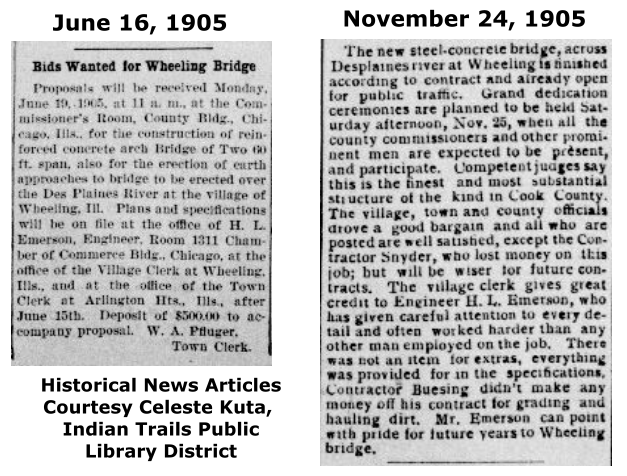
Celeste Kuta also provided a couple newspaper clippings about this. Vague mention is made of the contractor of the bridge in the clippings (shown below) who is mentioned as only "Snyder."
|
Rehabilitation Plaque STATION 10 + 58.7DES PLAINES RIVER REBUILT 1982 F.A. RTE. 528 SEC. 1977-288-BR FA PROJECT 1X-529 (19) LOADING HS 20 STR. NO. 016-0526 |
![]()
![]()
Complete Bridge List
Chicago and Cook County are home to one of the largest collections of historic bridges in the country, and no other city in the world has more movable bridges. HistoricBridges.org is proud to offer the most extensive coverage of historic Chicago bridges on the Internet.
General Chicago / Cook County Bridge Resources
Additional Online Articles and Resources - This page is a large gathering of interesting articles and resources that HistoricBridges.org has uncovered during research, but which were not specific to a particular bridge listing.
Chicago's Bridges - By Nathan Holth, author of HistoricBridges.org, this book provides a discussion of the history of Chicago's movable bridges, and includes a virtual tour discussing all movable bridges remaining in Chicago today. Despite this broad coverage, the book is presented in a compact format that is easy to take with you and carry around for reference on a visit to Chicago. The book includes dozens of full color photos. Only $9.95 U.S! ($11.95 Canadian). Order on Amazon.
Chicago River Bridges - By Patrick T. McBriarty, this is a great companion to Holth's book shown above. This much larger book offers an extremely in-depth exploration of Chicago's movable highway bridges, including many crossings that have not existed for many years. Order Now Direct From The Publisher! or order on Amazon.
View Historic American Engineering Record (HAER) Overview of Chicago Bascule Bridges (HAER Data Pages, PDF)
Chicago Loop Bridges - Chicago Loop Bridges is another website on the Internet that is a great companion to the HistoricBridges.org coverage of the 18 movable bridges within the Chicago Loop. This website includes additional information such as connections to popular culture, overview discussions and essays about Chicago's movable bridges, additional videos, and current news and events relating to the bridges.
![]()
![]()
![]()
Coordinates (Latitude, Longitude):
Search For Additional Bridge Listings:
Bridgehunter.com: View listed bridges within 0.5 miles (0.8 kilometers) of this bridge.
Bridgehunter.com: View listed bridges within 10 miles (16 kilometers) of this bridge.
Additional Maps:
Google Streetview (If Available)
GeoHack (Additional Links and Coordinates)
Apple Maps (Via DuckDuckGo Search)
Apple Maps (Apple devices only)
Android: Open Location In Your Map or GPS App
Flickr Gallery (Find Nearby Photos)
Wikimedia Commons (Find Nearby Photos)
Directions Via Sygic For Android
Directions Via Sygic For iOS and Android Dolphin Browser
USGS National Map (United States Only)
Historical USGS Topo Maps (United States Only)
Historic Aerials (United States Only)
CalTopo Maps (United States Only)

© Copyright 2003-2026, HistoricBridges.org. All Rights Reserved. Disclaimer: HistoricBridges.org is a volunteer group of private citizens. HistoricBridges.org is NOT a government agency, does not represent or work with any governmental agencies, nor is it in any way associated with any government agency or any non-profit organization. While we strive for accuracy in our factual content, HistoricBridges.org offers no guarantee of accuracy. Information is provided "as is" without warranty of any kind, either expressed or implied. Information could include technical inaccuracies or errors of omission. Opinions and commentary are the opinions of the respective HistoricBridges.org member who made them and do not necessarily represent the views of anyone else, including any outside photographers whose images may appear on the page in which the commentary appears. HistoricBridges.org does not bear any responsibility for any consequences resulting from the use of this or any other HistoricBridges.org information. Owners and users of bridges have the responsibility of correctly following all applicable laws, rules, and regulations, regardless of any HistoricBridges.org information.
![]()