We Recommend:
Bach Steel - Experts at historic truss bridge restoration.
BridgeHunter.com Phase 1 is released to the public! - Visit Now
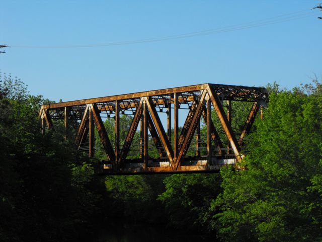
Evanston-Wilmette Railroad Bridge

Primary Photographer(s): Nathan Holth
Bridge Documented: May 29, 2009
Railroad (Chicago Transit Authority "L" Purple Line) Over North Shore Channel
Evanston: Cook County, Illinois: United States
1909 By Builder/Contractor: Wisconsin Bridge and Iron Company of Milwaukee, Wisconsin and Engineer/Design: Carlton R. Dart
Not Available or Not Applicable
175.0 Feet (53.3 Meters)
425.0 Feet (129.5 Meters)
Not Available
1 Main Span(s)
Not Applicable

View Information About HSR Ratings
Bridge Documentation
Additional Information: National Contracting Company of Chicago, Illinois was the substructure contractor. Wisconsin Bridge and Iron of Milwaukee was the superstructure contractor
Although clearly an attractive and historic structure, this bridge is nonetheless a traditional stationary riveted Warren through truss with no distinguishing details constructed within the period in which this type of bridge was frequently being built on railroad. However, perhaps this normalcy is what makes it stand out in Cook County, which is filled with movable truss bridges and other unusual bridge designs. It was built to carry the railroad over the North Shore Channel, and as such it has a Sanitary District plaque on it.
Please be aware that this is a CTA line which means it is not extremely busy, but it also has an electrified third rail. Walking on this bridge or related trackage is not recommended, and would likely result in one of several possible unpleasant consequences (police response, being flattened by a train, electrocuted to death, etc).
That said, there is an open field or golf course or some such thing that you can view this bridge from, particularly in the winter when the leaves are off the trees. A distance view of the bridge can be had from Central Street Bridge too.
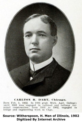
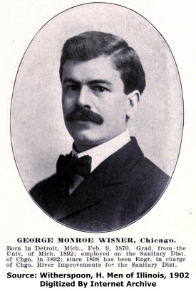
Carlton R. Dart (listed as C. R. Dart on the plaque) was the bridge engineer. George Monroe Wisner (George. M. Wisner on the plaque) was the chief engineer.
|
Main Plaque ERECTED BYTHE SANITARY DISTRICT ----- OF ----- CHICAGO ----- 1909 ----- PRESIDENT ROBERT R. MC CORMICK BOARD OF TRUSTEES WILLIAM H. BAKER ADOLPH BERGMAN WALLACE G. CLARK HENRY F. EIDMANN PAUL A. HAZARD THOMAS J. HEALY ROBERT R. MC CORMICK GEORGE W. PAULLIN EDWARD I. WILLIAMS CHIEF ENGINEER GEORGE M. WISNER BRIDGE ENGINEER C. R. DART BUILT FOR THE C. M. & ST. P. RY. CO. |
![]()
Historic Bridges of Chicago and Cook County


Chicago and Cook County are home to one of the largest collections of historic bridges in the country, and no other city in the world has more movable bridges. HistoricBridges.org is proud to offer the most extensive coverage of historic Chicago bridges on the Internet.
General Chicago / Cook County Bridge Resources
Chicago's Bridges - By Nathan Holth, author of HistoricBridges.org, this book provides a discussion of the history of Chicago's movable bridges, and includes a virtual tour discussing all movable bridges remaining in Chicago today. Despite this broad coverage, the book is presented in a compact format that is easy to take with you and carry around for reference on a visit to Chicago. The book includes dozens of full color photos. Only $9.95 U.S! ($11.95 Canadian). Order on Amazon.
Chicago River Bridges - By Patrick T. McBriarty, this is a great companion to Holth's book shown above. This much larger book offers an extremely in-depth exploration of Chicago's movable highway bridges, including many crossings that have not existed for many years. Order Now Direct From The Publisher! or order on Amazon.
View Historic American Engineering Record (HAER) Overview of Chicago Bascule Bridges (HAER Data Pages, PDF)
Chicago Loop Bridges - Chicago Loop Bridges is another website on the Internet that is a great companion to the HistoricBridges.org coverage of the 18 movable bridges within the Chicago Loop. This website includes additional information such as connections to popular culture, overview discussions and essays about Chicago's movable bridges, additional videos, and current news and events relating to the bridges.
Additional Online Articles and Resources - This page is a large gathering of interesting articles and resources that HistoricBridges.org has uncovered during research, but which were not specific to a particular bridge listing.
![]()
Photo Galleries and Videos: Evanston-Wilmette Railroad Bridge
Bridge Photo-Documentation
Original / Full Size PhotosA collection of overview and detail photos. This gallery offers photos in the highest available resolution and file size in a touch-friendly popup viewer.
Alternatively, Browse Without Using Viewer
![]()
Bridge Photo-Documentation
Mobile Optimized PhotosA collection of overview and detail photos. This gallery features data-friendly, fast-loading photos in a touch-friendly popup viewer.
Alternatively, Browse Without Using Viewer
![]()
Maps and Links: Evanston-Wilmette Railroad Bridge
Coordinates (Latitude, Longitude):
Search For Additional Bridge Listings:
Bridgehunter.com: View listed bridges within 0.5 miles (0.8 kilometers) of this bridge.
Bridgehunter.com: View listed bridges within 10 miles (16 kilometers) of this bridge.
Additional Maps:
Google Streetview (If Available)
GeoHack (Additional Links and Coordinates)
Apple Maps (Via DuckDuckGo Search)
Apple Maps (Apple devices only)
Android: Open Location In Your Map or GPS App
Flickr Gallery (Find Nearby Photos)
Wikimedia Commons (Find Nearby Photos)
Directions Via Sygic For Android
Directions Via Sygic For iOS and Android Dolphin Browser
USGS National Map (United States Only)
Historical USGS Topo Maps (United States Only)
Historic Aerials (United States Only)
CalTopo Maps (United States Only)


