

View Information About HSR Ratings
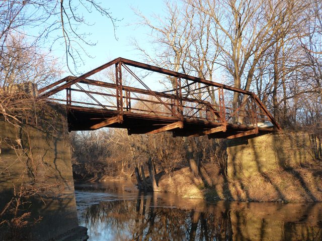
This bridge has a 1910 construction date given in the National Bridge Inventory. This date appears to be a default date placed in the database and does not appear to be correct based on the style of the bridge as well as the font used by Carnegie for its name that appears on many of the members of this bridge. The bridge appears to be wrought iron based on the lack of deterioration despite a lack of paint on the bridge. The bridge has built-up fishbelly style floor beams. Otherwise, the bridge is a traditionally composed example of a pin-connected truss bridge. These details all suggest that the bridge may date to between 1885 and 1895. The bridge is thus noteworthy as an unaltered and fairly early surviving example of its type. The builder of this bridge is unknown. The bridge's western abutment was reconstructed with concrete at some date long ago. The eastern abutment is stone.
The bridge is closed to traffic but from a restoration viewpoint, is in good condition and could easily be restored. Even in its current unrestored condition, the bridge does not appear to be at risk for collapse. Overall, there is little deterioration on the bridge. In particular, there is hardly any section loss on the members at the bottom chord connections, which is a traditional location for the worst deterioration on a truss bridge.
![]()
![]()
![]()
Coordinates (Latitude, Longitude):
Search For Additional Bridge Listings:
Bridgehunter.com: View listed bridges within 0.5 miles (0.8 kilometers) of this bridge.
Bridgehunter.com: View listed bridges within 10 miles (16 kilometers) of this bridge.
Additional Maps:
Google Streetview (If Available)
GeoHack (Additional Links and Coordinates)
Apple Maps (Via DuckDuckGo Search)
Apple Maps (Apple devices only)
Android: Open Location In Your Map or GPS App
Flickr Gallery (Find Nearby Photos)
Wikimedia Commons (Find Nearby Photos)
Directions Via Sygic For Android
Directions Via Sygic For iOS and Android Dolphin Browser
USGS National Map (United States Only)
Historical USGS Topo Maps (United States Only)
Historic Aerials (United States Only)
CalTopo Maps (United States Only)

© Copyright 2003-2026, HistoricBridges.org. All Rights Reserved. Disclaimer: HistoricBridges.org is a volunteer group of private citizens. HistoricBridges.org is NOT a government agency, does not represent or work with any governmental agencies, nor is it in any way associated with any government agency or any non-profit organization. While we strive for accuracy in our factual content, HistoricBridges.org offers no guarantee of accuracy. Information is provided "as is" without warranty of any kind, either expressed or implied. Information could include technical inaccuracies or errors of omission. Opinions and commentary are the opinions of the respective HistoricBridges.org member who made them and do not necessarily represent the views of anyone else, including any outside photographers whose images may appear on the page in which the commentary appears. HistoricBridges.org does not bear any responsibility for any consequences resulting from the use of this or any other HistoricBridges.org information. Owners and users of bridges have the responsibility of correctly following all applicable laws, rules, and regulations, regardless of any HistoricBridges.org information.
![]()