

View Information About HSR Ratings
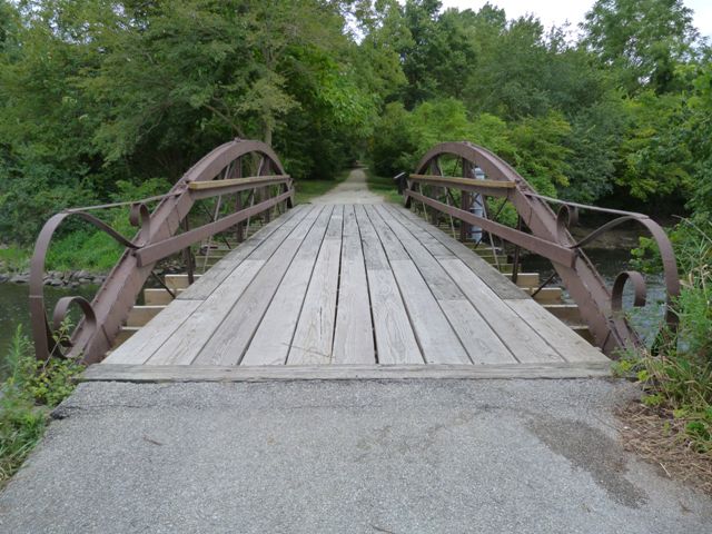
The Chicagoland area is noted for its large quantity of historic bridges, however this is the only known example in the region of a cast and wrought iron bowstring truss bridge. Usually dating to the 1870s, cast and wrought iron bowstring truss bridges are among the nation's oldest surviving metal bridges and are also among the rarest types of historic bridge in the country. Each surviving bridge is an essential part of our nation's transportation heritage and should receive the highest preservation priority. Built during a period of experimentation, these bridges display unusual construction details that were often the patented designs of the company that built them. This often makes builder identification of these bridges very easy even if a builder plaque is not present, as is the case with this bridge. Based on its design, this bridge is clearly the product of the King Iron Bridge Company of Cleveland, Ohio. The essential details are present including the built-up box beam top chord, and cast iron bottom chord connection assembly blocks. The decorative railing that extends from the ends of the arch to the end of the deck is composed of curved strips of iron. This is a detail that is found on only some of the surviving King Iron Bridge Company bowstring bridges.
This bridge currently carries a non-motorized path in the Hidden Lake Forest Preserve park. Given this location and function it would initially seem that the bridge was likely relocated from a highway and preserved in place here for non-motorized use. However, the bridge sits on rather old concrete abutments which suggests that although this may not be the bridge's original location, that the bridge has been here for a very long time. It was initially thought that a historical 1918 photo showing a similar bridge in Cook County along Forest Preserve lands might have been the same bridge in an original location. However upon closer inspection the bridge (shown below) appears slightly larger and lacks the ornamental railings at the ends of the bowstring trusses. The reality is there may have once been many bridges of this type in the area, long ago.
The Hidden Lake Forest Preserve Park Bridge has good historic integrity. Some welded repairs are visible, and a tear in part of the top chord was noted. The top chord also suffers from some pack rust. A load-bearing pier was added to the center of the bridge at an unknown date. While this pier does affect the engineering function of the truss, it does not affect the material integrity of the bridge. While some engineers might find the pier highly distasteful, HistoricBridges.org does not find it to be a serious issue. The beauty of this type of alteration is that it does not damage the physical integrity of the original bridge materials and could be removed as part of a restoration project for the bridge at any time down the road.
As of 2023, this historic bridge has been restored by Bach Steel so that it can continue to serve as an iconic historic bridge on this trail. As part of the restoration, the pier was removed, so the bridge looks as it did originally.
Chris Gingrich from the Forest Preserve District of DuPage County provided the following comments:
This section of trail was a public roadway prior to it becoming a forest preserve in the 1970s and the land around it was privately owned. According to some property records in our forest preserve files the road was known as Bryant Road and the township vacated the section including the bridge to the forest preserve district in 1983. Assuming Bryant Road goes back to the 1800s it is possible the bridge is in its original location.
A blog article had additional thoughts on the bridge:
This bridge sits on the former location of a highway. The above article states this road had many names: Barney Mill Road, Stauch Road, Bryant Road and Bryant Avenue. The road was originally used to haul timber to the Barney Sawmill from about 1837 to 1854. In 1924, Route 53 was planned to connect DuPage County south to north. This state highway could have followed the path through what is today the Forest Preserve, which would have meant replacing this bridge. Instead it appears IL-53 was aligned so as to curve around the area, thus sparing this bridge from demolition. Instead, the old road was turned into a driveway to a private farmhouse, where it served as a driveway bridge for 50 years. In 1983, the drive was vacated and turned over to the Forest Preserve District who included the bridge as part of its path system.

Above: This historical photo is believed to show the Hidden Lake Bridge.

![]()
![]()
![]()
Coordinates (Latitude, Longitude):
Search For Additional Bridge Listings:
Bridgehunter.com: View listed bridges within 0.5 miles (0.8 kilometers) of this bridge.
Bridgehunter.com: View listed bridges within 10 miles (16 kilometers) of this bridge.
Additional Maps:
Google Streetview (If Available)
GeoHack (Additional Links and Coordinates)
Apple Maps (Via DuckDuckGo Search)
Apple Maps (Apple devices only)
Android: Open Location In Your Map or GPS App
Flickr Gallery (Find Nearby Photos)
Wikimedia Commons (Find Nearby Photos)
Directions Via Sygic For Android
Directions Via Sygic For iOS and Android Dolphin Browser
USGS National Map (United States Only)
Historical USGS Topo Maps (United States Only)
Historic Aerials (United States Only)
CalTopo Maps (United States Only)

© Copyright 2003-2026, HistoricBridges.org. All Rights Reserved. Disclaimer: HistoricBridges.org is a volunteer group of private citizens. HistoricBridges.org is NOT a government agency, does not represent or work with any governmental agencies, nor is it in any way associated with any government agency or any non-profit organization. While we strive for accuracy in our factual content, HistoricBridges.org offers no guarantee of accuracy. Information is provided "as is" without warranty of any kind, either expressed or implied. Information could include technical inaccuracies or errors of omission. Opinions and commentary are the opinions of the respective HistoricBridges.org member who made them and do not necessarily represent the views of anyone else, including any outside photographers whose images may appear on the page in which the commentary appears. HistoricBridges.org does not bear any responsibility for any consequences resulting from the use of this or any other HistoricBridges.org information. Owners and users of bridges have the responsibility of correctly following all applicable laws, rules, and regulations, regardless of any HistoricBridges.org information.
![]()