

View Information About HSR Ratings
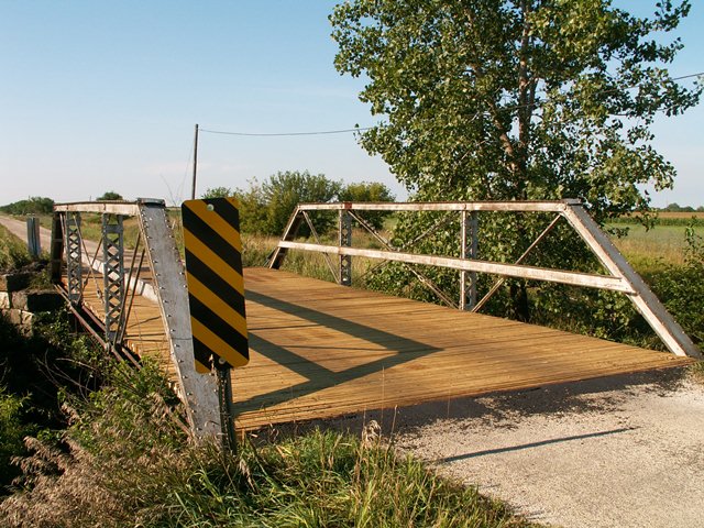
This bridge had just received a new deck in 2006 when it was documented by HistoricBridges.org. The pile of old wood was next to the bridge. The bridge was a small three panel half-hip pony truss. A couple alterations were present on the structure, including the addition of wire cable diagonal members that replaced or functioned alongside the center diagonals on the western truss. There was also some welding done to the top chord on this western truss which appeared to be the result of a sample test coupon being removed from the bridge. The bridge was seated on stone abutments. There was v-lacing present on the verticals. Channel railing was present on the bridge.
The deck replacement in 2006 might have led some to believe that Iroquois County actually cared about this and other historic bridges in the county. Nothing could be further from the truth. The bridge was demolished and replaced in 2010, becoming the latest in a historic truss bridge slaughter that started a few years before HistoricBridges.org visited the county in 2006, and as of 2013 has continued relentlessly. A county that once had one of the largest and most impressive collection of historic metal truss bridges in Illinois is reducing its collection to nearly nothing.
![]()
![]()
![]()
This historic bridge has been demolished. This map is shown for reference purposes only.
Coordinates (Latitude, Longitude):
Search For Additional Bridge Listings:
Bridgehunter.com: View listed bridges within 0.5 miles (0.8 kilometers) of this bridge.
Bridgehunter.com: View listed bridges within 10 miles (16 kilometers) of this bridge.
Additional Maps:
Google Streetview (If Available)
GeoHack (Additional Links and Coordinates)
Apple Maps (Via DuckDuckGo Search)
Apple Maps (Apple devices only)
Android: Open Location In Your Map or GPS App
Flickr Gallery (Find Nearby Photos)
Wikimedia Commons (Find Nearby Photos)
Directions Via Sygic For Android
Directions Via Sygic For iOS and Android Dolphin Browser
USGS National Map (United States Only)
Historical USGS Topo Maps (United States Only)
Historic Aerials (United States Only)
CalTopo Maps (United States Only)

© Copyright 2003-2026, HistoricBridges.org. All Rights Reserved. Disclaimer: HistoricBridges.org is a volunteer group of private citizens. HistoricBridges.org is NOT a government agency, does not represent or work with any governmental agencies, nor is it in any way associated with any government agency or any non-profit organization. While we strive for accuracy in our factual content, HistoricBridges.org offers no guarantee of accuracy. Information is provided "as is" without warranty of any kind, either expressed or implied. Information could include technical inaccuracies or errors of omission. Opinions and commentary are the opinions of the respective HistoricBridges.org member who made them and do not necessarily represent the views of anyone else, including any outside photographers whose images may appear on the page in which the commentary appears. HistoricBridges.org does not bear any responsibility for any consequences resulting from the use of this or any other HistoricBridges.org information. Owners and users of bridges have the responsibility of correctly following all applicable laws, rules, and regulations, regardless of any HistoricBridges.org information.
![]()