

View Information About HSR Ratings
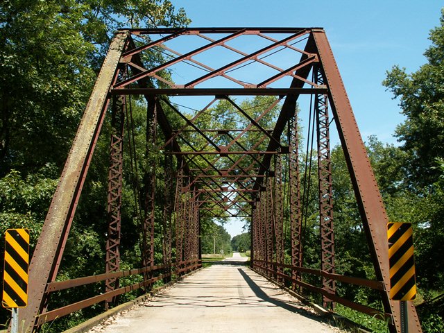
Back in 2006, when HistoricBridges.org documented Iroquois County, the following statement was placed into the narrative: "Iroquois County is filled with a large number of remaining truss bridges, must most are no larger than 100 feet in length, and many are short pony trusses." As of 2013, this statement is no longer accurate. Iroquois County has demolished a large number of its truss bridges and only a small number remain. In 2006, this bridge, a pin-connected Pratt through truss with a relatively long 143 foot span. At the time, it was the longest of a number of through truss bridges in the county. Today, it appears that this is the only through truss of any size in the entire county!
The demolition of Iroquois County's bridges since the turn of the 21st Century has been so widespread and unrelenting that it is enough to reduce any bridge historian to tears. A county that had an amazingly large and complete collection of historic bridges has nearly annihilated that collection. As such, this bridge is likely at risk for demolition as well. However, HistoricBridges.org urges Iroquois County to rehabilitate this bridge instead, something that likely costs less than it would to replace the bridge. This would at least ensure that the county does not lose everything and would prevent Iroquois County from becoming a county that does not have a single through truss remaining.
The bridge is an eight panel structure, and is does not fall into the pattern of similar design as other Iroquois County truss bridges did. The portal bracing is a large lattice design, while the sway bracing also employ an even larger and simpler lattice design. There is v-lacing on the verticals and under the top chord and end posts. The base of the deck is concrete. The abutments are also concrete.
![]()
![]()
![]()
Coordinates (Latitude, Longitude):
Search For Additional Bridge Listings:
Bridgehunter.com: View listed bridges within 0.5 miles (0.8 kilometers) of this bridge.
Bridgehunter.com: View listed bridges within 10 miles (16 kilometers) of this bridge.
Additional Maps:
Google Streetview (If Available)
GeoHack (Additional Links and Coordinates)
Apple Maps (Via DuckDuckGo Search)
Apple Maps (Apple devices only)
Android: Open Location In Your Map or GPS App
Flickr Gallery (Find Nearby Photos)
Wikimedia Commons (Find Nearby Photos)
Directions Via Sygic For Android
Directions Via Sygic For iOS and Android Dolphin Browser
USGS National Map (United States Only)
Historical USGS Topo Maps (United States Only)
Historic Aerials (United States Only)
CalTopo Maps (United States Only)

© Copyright 2003-2026, HistoricBridges.org. All Rights Reserved. Disclaimer: HistoricBridges.org is a volunteer group of private citizens. HistoricBridges.org is NOT a government agency, does not represent or work with any governmental agencies, nor is it in any way associated with any government agency or any non-profit organization. While we strive for accuracy in our factual content, HistoricBridges.org offers no guarantee of accuracy. Information is provided "as is" without warranty of any kind, either expressed or implied. Information could include technical inaccuracies or errors of omission. Opinions and commentary are the opinions of the respective HistoricBridges.org member who made them and do not necessarily represent the views of anyone else, including any outside photographers whose images may appear on the page in which the commentary appears. HistoricBridges.org does not bear any responsibility for any consequences resulting from the use of this or any other HistoricBridges.org information. Owners and users of bridges have the responsibility of correctly following all applicable laws, rules, and regulations, regardless of any HistoricBridges.org information.
![]()