We Recommend:
Bach Steel - Experts at historic truss bridge restoration.
BridgeHunter.com Phase 1 is released to the public! - Visit Now
Jackson Boulevard Bridge
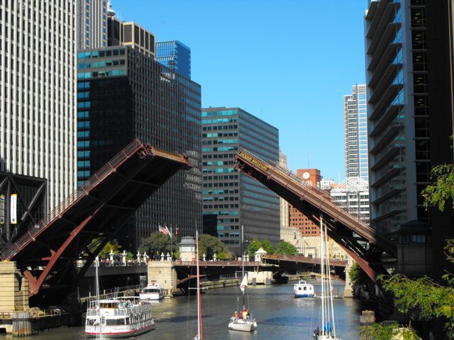
Primary Photographer(s): Nathan Holth
Bridge Documented: August 12, 2006 - October 7, 2017
Jackson Boulevard (Historic US-66) Over South Branch Chicago River
Chicago: Cook County, Illinois: United States
Metal Rivet-Connected Pratt Deck Truss, Movable: Double Leaf Bascule (Strauss Trunnion) and Approach Spans: Metal Stringer (Multi-Beam), Fixed
1915 By Builder/Contractor: Strobel Steel Construction Company of Chicago, Illinois and Engineer/Design: Strauss Bascule Bridge Company (Strauss Engineering Company) of Chicago, Illinois
1993
202.0 Feet (61.6 Meters)
273.0 Feet (83.2 Meters)
37 Feet (11.28 Meters)
1 Main Span(s) and 3 Approach Span(s)
16602627329

View Information About HSR Ratings
Bridge Documentation
View Archived National Bridge Inventory Report - Has Additional Details and Evaluation
View Historic American Engineering Record (HAER) Documentation For This Bridge
HAER Data Pages, PDF
View Historical Articles About This Bridge
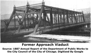
View A Historical Article About The Former Approach Span At This Location
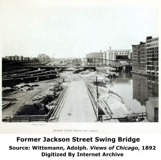
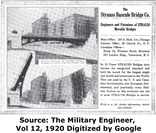
With a 1915 construction date, this bridge is one of the oldest of the deck truss style bascule bridges in Chicago, and is thus historically significant. During this time. Joseph Strauss and his Strauss Bascule Bridge Company had various conflicts with the City of Chicago because he felt his patents were being violated by the city. In this case however, the Strauss Bascule Bridge Company served as a consulting engineer. There is a second little plaque on this bridge that says this Strauss Trunnion Bascule bridge is operated under license by the Strauss Bascule Bridge Company. Another oddity of this bridge is that unlike most of the downtown loop bridges, the Sanitary District of Chicago took the lead in building this bridge. The City of Chicago was apparently lacking money at the time and their was pressure to remove swing bridges from the river. This bridge replaced an 1888 swing bridge that consisted of a 17 panel Camelback truss with three truss lines providing a 58 foot wide and 280 foot long bridge.
The bridge's superstructure was built by the Strobel Steel Construction Company, while the substructure was built by the Great Lakes Dredge and Dock Company. The bridge has a clear span of 173.5 Feet (202 Feet trunnion to trunnion length), 15.74 feet navigational vertical clearance, and the bridge is 64 feet wide.
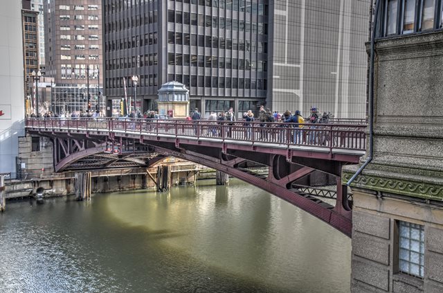
This bridge is visually appealing because its arch is very smooth and has a graceful appearance to it compared to the more polygonal appearance of other Chicago deck truss bridges.
Beginning in 1933, Jackson Boulevard including this bridge was part of US-66. As such, the bridge is today part of Historic Route 66.
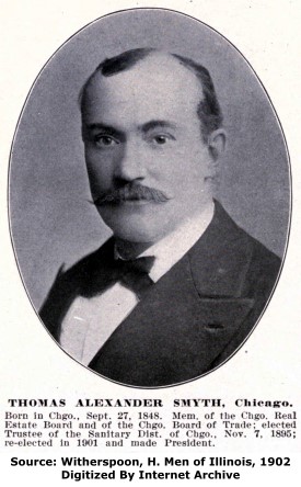
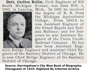
Thomas Alexander Smyth, president of the Sanitary District of Chicago when this bridge was constructed is shown in a portrait to the right. At the bottom of this page, a portrait of the Chief Bridge Engineer for the Sanitary District, Carlton Dart, is shown.
Although it may have been considered ugly and utilitarian at the time it was built, if it stood today, the previous (and first documented) bridge at this location would been a stunning example of Victorian bridge construction. The bridge was built in 1888 by the Detroit Bridge Company and consisted of a large pin-connected through truss center pier swing bridge. It was 280 feet long and 59 feet wide. As a wide bridge, it included three truss lines, with the center truss line dividing the roadway into two halves. The bridge included a beautiful ornamental portal bracing design topped off with a highly ornate portal cresting and finials. Although a center-pier swing bridge, the pier was not located in the water, but instead rested on the western shore. The eastern half of the swing span crossed the river, while the other half carried the roadway over railroad tracks. There was also a fixed span at the western end of the crossing that provided an approach to the bridge, crossing over additional railroad tracks. Like the swing bridge, this structure was also a pin-connected through truss with an ornate portal design. It also included ornate sidewalk railings and a builder plaque mounted on the portal bracing.
|
Main Plaque ERECTED 1915 BYTHE SANITARY DISTRICT OF CHICAGO ----- BOARD OF TRUSTEES ----- THOMAS A. SMYTH, PRESIDENT
|
Patent Plaque STRAUSS TRUNNION BASCULE BRIDGEPATENT NO. 995813 OPERATED UNDER LICENSE FROM THE STRAUSS BASCULE BRIDGE CO. CHICAGO |
![]()
Historic Bridges of Chicago and Cook County


Chicago and Cook County are home to one of the largest collections of historic bridges in the country, and no other city in the world has more movable bridges. HistoricBridges.org is proud to offer the most extensive coverage of historic Chicago bridges on the Internet.
General Chicago / Cook County Bridge Resources
Chicago's Bridges - By Nathan Holth, author of HistoricBridges.org, this book provides a discussion of the history of Chicago's movable bridges, and includes a virtual tour discussing all movable bridges remaining in Chicago today. Despite this broad coverage, the book is presented in a compact format that is easy to take with you and carry around for reference on a visit to Chicago. The book includes dozens of full color photos. Only $9.95 U.S! ($11.95 Canadian). Order on Amazon.
Chicago River Bridges - By Patrick T. McBriarty, this is a great companion to Holth's book shown above. This much larger book offers an extremely in-depth exploration of Chicago's movable highway bridges, including many crossings that have not existed for many years. Order Now Direct From The Publisher! or order on Amazon.
View Historic American Engineering Record (HAER) Overview of Chicago Bascule Bridges (HAER Data Pages, PDF)
Chicago Loop Bridges - Chicago Loop Bridges is another website on the Internet that is a great companion to the HistoricBridges.org coverage of the 18 movable bridges within the Chicago Loop. This website includes additional information such as connections to popular culture, overview discussions and essays about Chicago's movable bridges, additional videos, and current news and events relating to the bridges.
Additional Online Articles and Resources - This page is a large gathering of interesting articles and resources that HistoricBridges.org has uncovered during research, but which were not specific to a particular bridge listing.
This bridge is tagged with the following special condition(s): Unorganized Photos
![]()
Photo Galleries and Videos: Jackson Boulevard Bridge
Bridge Photo-Documentation
Original / Full Size PhotosA collection of overview and detail photos. This gallery offers photos in the highest available resolution and file size in a touch-friendly popup viewer.
Alternatively, Browse Without Using Viewer
![]()
Bridge Photo-Documentation
Mobile Optimized PhotosA collection of overview and detail photos. This gallery features data-friendly, fast-loading photos in a touch-friendly popup viewer.
Alternatively, Browse Without Using Viewer
![]()
Additional Unorganized Photos
Original / Full Size PhotosA supplemental collection of photos that are from additional visit(s) to the bridge and have not been organized or captioned. This gallery offers photos in the highest available resolution and file size in a touch-friendly popup viewer.
Alternatively, Browse Without Using Viewer
![]()
Additional Unorganized Photos
Mobile Optimized PhotosA supplemental collection of photos that are from additional visit(s) to the bridge and have not been organized or captioned. This gallery features data-friendly, fast-loading photos in a touch-friendly popup viewer.
Alternatively, Browse Without Using Viewer
![]()
Raising Bridge, Single Leaf
Full Motion VideoTaken 2017 Streaming video of the bridge. Also includes a higher quality downloadable video for greater clarity or offline viewing.
![]()
Raising Bridge, Portal
Full Motion VideoTaken June 2011 Streaming video of the bridge. Also includes a higher quality downloadable video for greater clarity or offline viewing.
![]()
Bridge Being Raised
Full Motion VideoStreaming video of the bridge. Also includes a higher quality downloadable video for greater clarity or offline viewing.
![]()
Maps and Links: Jackson Boulevard Bridge
Coordinates (Latitude, Longitude):
Search For Additional Bridge Listings:
Bridgehunter.com: View listed bridges within 0.5 miles (0.8 kilometers) of this bridge.
Bridgehunter.com: View listed bridges within 10 miles (16 kilometers) of this bridge.
Additional Maps:
Google Streetview (If Available)
GeoHack (Additional Links and Coordinates)
Apple Maps (Via DuckDuckGo Search)
Apple Maps (Apple devices only)
Android: Open Location In Your Map or GPS App
Flickr Gallery (Find Nearby Photos)
Wikimedia Commons (Find Nearby Photos)
Directions Via Sygic For Android
Directions Via Sygic For iOS and Android Dolphin Browser
USGS National Map (United States Only)
Historical USGS Topo Maps (United States Only)
Historic Aerials (United States Only)
CalTopo Maps (United States Only)


