We Recommend:
Bach Steel - Experts at historic truss bridge restoration.
BridgeHunter.com Phase 1 is released to the public! - Visit Now
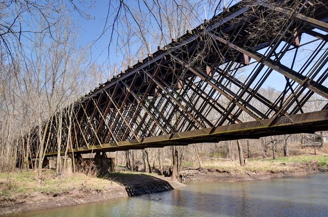
Lick Creek Railroad Bridge

Primary Photographer(s): Nathan Holth
Bridge Documented: March 21, 2016
Railroad (Chicago and North Western Railroad) Over Lick Creek
Rural: Sangamon County, Illinois: United States
Metal Rivet-Connected Lattice (Quadruple Warren) Deck Truss, Fixed and Approach Spans: Concrete Deck Girder, Fixed
1883 By Builder/Contractor: Alden and Lassig Bridge and Iron Works of Chicago, Illinois
1921
123.0 Feet (37.5 Meters)
425.0 Feet (129.5 Meters)
Not Available
3 Main Span(s) and 2 Approach Span(s)
Not Applicable

View Information About HSR Ratings
Bridge Documentation
Bridge dimensions given are extremely rough estimates. This rare multi-span lattice deck truss is a surprising find over this small creek. Technically, it goes over two waterways, Lick Creek plus a small tributary. It is abandoned. It is a traditional example of its type. The Chicago and North Western Railroad, unlike other railroad companies, preferred lattice truss bridges and built many of them. Thus, while lattice trusses are rare in general, they are more common on railroad lines associated with Chicago and North Western Railroad. There is a riveted steel stringer highway bridge on unusual roller bearings next to this bridge on Wesley Chapel Road which was not historic enough to be listed, but a few photos of it are included in the gallery too. The highway bridge appears to have since been closed to traffic.
John Marvig did some research on this bridge and found some important information: This bridge was built 1883 at Geneva, IL as Spans A&D of Bridge #66; these spans were moved here in 1921. I would assume the builder is Alden & Lassig, but I cannot confirm at this time. From what we have figured out, the original Geneva bridge had three truss lines on four spans (two long spans and two short spans). The outer truss lines were the "light" lines, the inner truss line between the two tracks was the "heavy" line. It seems that the two short/heavy lines were sent to Spring Creek, and the two heavy/long lines were sent to Lick Creek, along with the four light/short and four light/long truss lines. These were double trussed to make them stronger. The Lick Creek bridge has three spans, and the north and south spans are the "light" trusses, which were double trussed. The middle span is the "heavy" truss, which explains why it uses a conventional layout. I am still trying to figure out if the "heavy" trusses are original to the 1883 bridge, or were added later.
John's research indicates that this is an extremely old surviving example of a rivet-connected truss bridge.
See the existing Geneva Railroad Bridge and a photo of the 1883 version on this page.
![]()
Photo Galleries and Videos: Lick Creek Railroad Bridge
Bridge Photo-Documentation
Original / Full Size PhotosA collection of overview and detail photos. This gallery offers photos in the highest available resolution and file size in a touch-friendly popup viewer.
Alternatively, Browse Without Using Viewer
![]()
Bridge Photo-Documentation
Mobile Optimized PhotosA collection of overview and detail photos. This gallery features data-friendly, fast-loading photos in a touch-friendly popup viewer.
Alternatively, Browse Without Using Viewer
![]()
Maps and Links: Lick Creek Railroad Bridge
Coordinates (Latitude, Longitude):
Search For Additional Bridge Listings:
Bridgehunter.com: View listed bridges within 0.5 miles (0.8 kilometers) of this bridge.
Bridgehunter.com: View listed bridges within 10 miles (16 kilometers) of this bridge.
Additional Maps:
Google Streetview (If Available)
GeoHack (Additional Links and Coordinates)
Apple Maps (Via DuckDuckGo Search)
Apple Maps (Apple devices only)
Android: Open Location In Your Map or GPS App
Flickr Gallery (Find Nearby Photos)
Wikimedia Commons (Find Nearby Photos)
Directions Via Sygic For Android
Directions Via Sygic For iOS and Android Dolphin Browser
USGS National Map (United States Only)
Historical USGS Topo Maps (United States Only)
Historic Aerials (United States Only)
CalTopo Maps (United States Only)

