

View Information About HSR Ratings
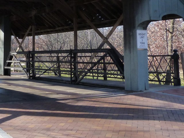
Before anyone wonders what a covered bridge is doing on a website dedicated to documenting all types of historic bridges except covered bridges, please note that this bridge is absolutely not a covered bridge. It is a historic metal truss bridge that had a fake wooden covering added to it. In fact, this bridge is a perfect demonstration of why HistoricBridges.org does not include covered bridges in its listings. Covered bridges have always been preserved in large numbers while all other historic bridge types are rarely preserved with most being demolished and replaced. Chicagoland is one of the few places where a substantial number of non-covered bridges appear to have been preserved. Obsession with covered bridges in the United States is so great that a genuine, beautiful, historic metal truss bridge would be covered in wood to make it look like a covered bridge. Such is the fate of this bridge. This beautiful historic metal truss bridge has been rehabilitated, is in good structural condition, yet its beauty and heritage is obscured by a fake wooden covering that only serves to create a false sense of history, something historians agree is something to avoid in preservation work. The historic metal truss bridge is all by itself a genuine historic bridge that would contribute greatly to this historic charm all on its own. It does not need to pretend to be a historic bridge with a fake wooden covering. It is itself a historic bridge.
Long Grove is a small, wealthy village that, under the direction of Robert Parker Coffin (whom this bridge's road is named after) worked to make sure that the village passed regulations to maintain its historic character. As such, its small downtown retains its small town historic charm. This historic bridge is located at the western end of this downtown area. While both a historical photo from the local historical society as well as common sense make it obvious that the wooden covering is not part of the original bridge, it does appear that the wooden covering is not new. Apparently, Robert Parker Coffin was also responsible for adding the wooden covering to this bridge in 1973. One online source claims that the covering was added to the bridge to protect the trusses from deterioration from weather. Even if this was why the covering was added, this would not have been useful. The two largest sources of deterioration for a metal truss bridge are winter deicing salt and moisture. Salt-laden water splashed up onto the trusses by cars in the winter has a devastating effect on any truss that is not thoroughly protected by a well-maintained coat of paint. If the goal was to protect the bridge from deterioration in 1973, the bridge should have simply been blast cleaned and repainted. The wooden covering would only have kept the trusses in the shade and increased the time it would take for any moisture on the bridge to dry up, and as such might be argued as a source for increased rate of deterioration.
Likely due to a combination of the long-lived American romanticism with covered bridges as well as the fairly old age of the alteration, the bridge is today locally known as the "covered bridge" and the bridge is cherished as such. Its great to see that this historic bridge is loved by the community, however it is sad that the love is not directed at the original metal trusses which not only carry traffic but hold all that wood up as well.
While Chicagoland has many historic bridges, it has strikingly few historic pin-connected truss bridges like the Long Grove Bridge. The bridge has fair historic integrity with some alterations. A large number of rivets have been replaced with modern bolts on the bridge, mainly on the top chord and end post. This is a reversible alteration, and the bolts could be replaced with historically correct rivets if the will was there. The original loop-forged eyebar diagonal members remain on the bridge. Under the bridge, original stone abutments remain, and the rolled American Standard Beam type i-beam floorbeams remain on the bridge. The truss webs each retain an original pair of channels for vehicular railing. The single cantilevered sidewalk has one of the most notable features of this bridge, which is original ornate pedestrian hand railing, consisting of two unequally tall rows of lattice. The ends of this hand railing terminate at beautiful cast iron posts. The presence of a sidewalk on this bridge as well as its decorative hand railing are indications that this bridge was built in a more urban environment. Most surviving pin-connected pony truss bridges are located in rural areas. As such, this bridge is a rare surviving example of a metal truss bridge built in an urban environment and retaining the sidewalk and railing that identifies it as such. It is one of the few pin-connected truss highway bridges remaining in Chicagoland. It also is the only known surviving pin-connected truss bridge in Lake County.
The National Bridge Inventory lists a 1925 construction date for that bridge. For a bridge of this type, that date is almost certainly incorrect since the bridge likely dates to before 1910 at least. By 1925, bridges would have had wider decks, more massive members, and would use riveted connections. One online source lists a 1902 construction date. This date seems appropriate given the style of the bridge and may very well be correct.
It may be wishful thinking, but if Long Grove would realize that they have been living a lie with the fake wooden covering that serves no useful purpose, and they would take the covering off of this bridge, and replace those modern bolts with historically correct rivets, Long Grove would be left with a bridge with excellent historic integrity that would visually transport visitors right back to the early 20th Century when this bridge was put into service.
![]()
![]()
![]()
Coordinates (Latitude, Longitude):
Search For Additional Bridge Listings:
Bridgehunter.com: View listed bridges within 0.5 miles (0.8 kilometers) of this bridge.
Bridgehunter.com: View listed bridges within 10 miles (16 kilometers) of this bridge.
Additional Maps:
Google Streetview (If Available)
GeoHack (Additional Links and Coordinates)
Apple Maps (Via DuckDuckGo Search)
Apple Maps (Apple devices only)
Android: Open Location In Your Map or GPS App
Flickr Gallery (Find Nearby Photos)
Wikimedia Commons (Find Nearby Photos)
Directions Via Sygic For Android
Directions Via Sygic For iOS and Android Dolphin Browser
USGS National Map (United States Only)
Historical USGS Topo Maps (United States Only)
Historic Aerials (United States Only)
CalTopo Maps (United States Only)

© Copyright 2003-2026, HistoricBridges.org. All Rights Reserved. Disclaimer: HistoricBridges.org is a volunteer group of private citizens. HistoricBridges.org is NOT a government agency, does not represent or work with any governmental agencies, nor is it in any way associated with any government agency or any non-profit organization. While we strive for accuracy in our factual content, HistoricBridges.org offers no guarantee of accuracy. Information is provided "as is" without warranty of any kind, either expressed or implied. Information could include technical inaccuracies or errors of omission. Opinions and commentary are the opinions of the respective HistoricBridges.org member who made them and do not necessarily represent the views of anyone else, including any outside photographers whose images may appear on the page in which the commentary appears. HistoricBridges.org does not bear any responsibility for any consequences resulting from the use of this or any other HistoricBridges.org information. Owners and users of bridges have the responsibility of correctly following all applicable laws, rules, and regulations, regardless of any HistoricBridges.org information.
![]()