

View Information About HSR Ratings
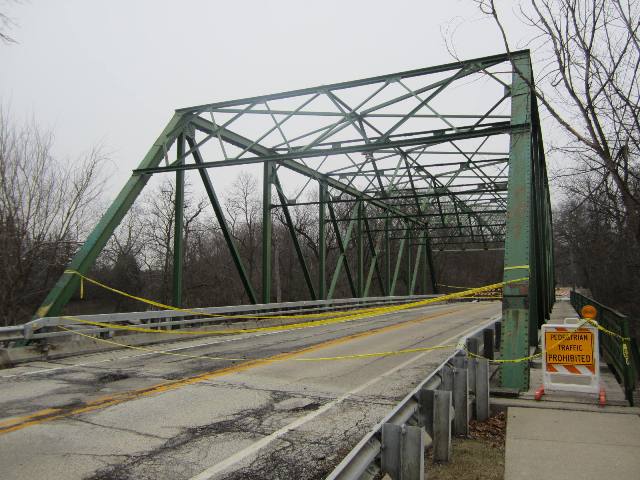
Note: Span length is an estimate. This bridge was built in 1921 as the western span of a bridge that carried US-51 over the Kaskaskia River Bridge at Vandalia, Illinois. This span was relocated here in 1962. Reportedly, the span was delivered to Libertyville in 5 truckloads and saved the city over $40,000. The bridge was a replacement for a previous bridge at this location, as surviving stone abutments under the bridge make apparent. In 1990, a new concrete bridge was built, but the trusses were reused as decorations, placed on top of the new bridge. At some point, the truss span was widened from their original width. However, in 2018, the bridge was closed when it was determined that the trusses had deteriorated and even as decorations were at risk for collapse. Thus, this bridge serves as a grim reminder. Sometimes, placing a truss as a non-structural decoration on a replacement seems like a good compromise at the time. However, such agreements should always include an agreement to maintain the decorative trusses as if they were structural elements. Although they are just decorations, the steel must still be maintained so the truss can continue to support itself. This has been a problem with other similar compromises elsewhere. HistoricBridges.org suggests that no State Historic Preservation Office should sign off on this type of alteration as an outcome of Section 106 mitigation unless a commitment to maintain the non-structural trusses is present.
This bridge is tagged with the following special condition(s): Trusses Converted To Decorative
![]()
![]()
![]()
This historic bridge has been demolished. This map is shown for reference purposes only.
Coordinates (Latitude, Longitude):
Search For Additional Bridge Listings:
Bridgehunter.com: View listed bridges within 0.5 miles (0.8 kilometers) of this bridge.
Bridgehunter.com: View listed bridges within 10 miles (16 kilometers) of this bridge.
Additional Maps:
Google Streetview (If Available)
GeoHack (Additional Links and Coordinates)
Apple Maps (Via DuckDuckGo Search)
Apple Maps (Apple devices only)
Android: Open Location In Your Map or GPS App
Flickr Gallery (Find Nearby Photos)
Wikimedia Commons (Find Nearby Photos)
Directions Via Sygic For Android
Directions Via Sygic For iOS and Android Dolphin Browser
USGS National Map (United States Only)
Historical USGS Topo Maps (United States Only)
Historic Aerials (United States Only)
CalTopo Maps (United States Only)

© Copyright 2003-2026, HistoricBridges.org. All Rights Reserved. Disclaimer: HistoricBridges.org is a volunteer group of private citizens. HistoricBridges.org is NOT a government agency, does not represent or work with any governmental agencies, nor is it in any way associated with any government agency or any non-profit organization. While we strive for accuracy in our factual content, HistoricBridges.org offers no guarantee of accuracy. Information is provided "as is" without warranty of any kind, either expressed or implied. Information could include technical inaccuracies or errors of omission. Opinions and commentary are the opinions of the respective HistoricBridges.org member who made them and do not necessarily represent the views of anyone else, including any outside photographers whose images may appear on the page in which the commentary appears. HistoricBridges.org does not bear any responsibility for any consequences resulting from the use of this or any other HistoricBridges.org information. Owners and users of bridges have the responsibility of correctly following all applicable laws, rules, and regulations, regardless of any HistoricBridges.org information.
![]()