We Recommend:
Bach Steel - Experts at historic truss bridge restoration.
BridgeHunter.com Phase 1 is released to the public! - Visit Now
Bernard Street Bridge

Primary Photographer(s): Nathan Holth
Bridge Documented: June 2, 2015
Chicago: Cook County, Illinois: United States
1885 By Builder/Contractor: Alden and Lassig Bridge and Iron Works of Chicago, Illinois
Not Available or Not Applicable
70.0 Feet (21.3 Meters)
70.0 Feet (21.3 Meters)
Not Available
1 Main Span(s)
Not Applicable

View Information About HSR Ratings
Bridge Documentation
The Bernard Street Bridge is a footbridge that appears to be unique among Chicago's rich and diverse collection of historic bridges, and with an original construction date of 1885, it is one of the oldest known surviving bridges in the city. Based on its truss configuration, design of built-up beams, and evidence of alteration, the bridge is clearly a relocated and reused bridge, and its design alone makes it clear the bridge was originally either a highway-over-railroad overpass (most likely scenario) or a bridge that carried a railroad. Further research outlined below has confirmed this. Although generally uncommon as a truss configuration, the double-intersection Warren pony truss design is one that is found on a number of railroad overpasses. Although the various examples across the country are not identical, they often share a number of details like preference for use of angle in diagonal members, and unusually tall side plates composing a somewhat narrow built-up top chord, bottom chord, and end post. Multiple railroad lines appear to have used this general design of bridge including notable railroads in Chicago's history such as the Chicago and Northwestern Railroad and also the Chicago, Rock Island, and Pacific Railroad.
The Carnegie name was found on one of the diagonal members indicating that Carnegie produced at least some of the metal on the bridge.
The bridge has many layers of paint including areas of spot-painting as well as evidence of some layers peeling away. What is interesting about all this is the bridge has nearly every color of paint used by the City of Chicago on its bridges in recent years including the off-white used many years ago, the maroon used today, and the brownish paint sometimes found when the city has spot painted bridges.
Although the Bernard Street Bridge is relocated and has a number of alterations, the trusses themselves overall retain good historic integrity with no major alterations. An example of an uncommon truss type, and the only known example in Chicago and Cook County, this bridge should be considered historically and technologically significant on the local and state level.
Bridge History
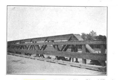
John Marvig conducted some research to unravel the mystery of this bridge. The bridge was originally built in 1885 by Alden and Lassig Bridge and Iron Works of Chicago, Illinois as a multi-span bridge carrying 61st Street over Chicago, Rock Island & Pacific Railway and Lake Shore & Michigan Southern Railroad (41.78315, -87.62815). In 1899, this bridge was replaced, and three truss spans were relocated to various locations in the city for reuse. One identified location was over North Branch Chicago River on Addison Street (41.946699, -87.696298) where one span served until 1920. A second span may have gone to Kedzie Avenue over North Branch Chicago River (41.974678, -87.708651). A third span was over North Branch Chicago River at Lawrence Avenue (41.968552, -87.701062) where it served until 1919. In 1919, the Lawrence Avenue Bridge was replaced and the truss span was once again moved, after a period of storage, in 1924.
A Railroad Gazette article dated to July 1, 1898 stated: "Alderman Kimbell wants the council to appropriate $10,000 for new bridges across the north branch of the Chicago River at Addison street, Lawrence avenue, and Kedzie avenue. His suggestion is to use the spans of the old Sixty-first street viaduct, recently taken down to make room for the elevation of the railroad tracks at that point."

Above: Historical photo showing one of the spans at Addison Street. Source: Structural Design, Volume 2, By Horace Richmond Thayer, 1914.
Earlier Research Notes
The origins of the Bernard Street Bridge were initially unknown. It appeared the bridge was moved here a long time ago, as the approach stairway and railing posts are very old looking. Additionally, the little struts that were added overhead also appear to be very old. A historical photo on this page shows the bridge in 1942, so it has been here at least this long. Although difficult to see, or confirm, it appears from historical aerial images that it was here at least as early as 1938 as well. 1938 was the oldest aerial image available to check. A Chicago Annual Report of the Public Works Department mentioned a survey of Bernard Street for the future intent of a bridge being constructed at Bernard Street, stating "During the year 1911, surveys were made at the following streets crossing the North Branch of the Chicago River,in contemplation of new construction: Kimball Avenue, Central Park Avenue, Bernard Street and Spaulding Avenue." So a bridge was being considered as early as 1911, however this doesn't mean that the bridge was erected here anytime soon after that date. However, it implies that the bridge was not placed here until after 1911.
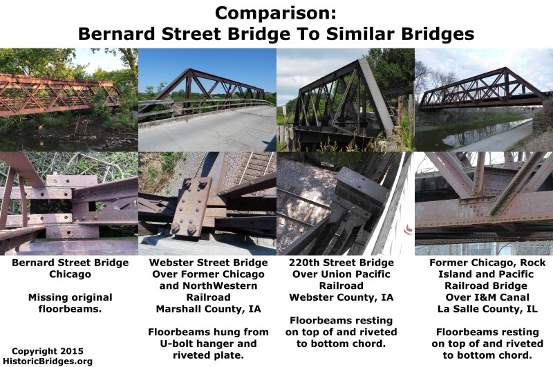
When the bridge was moved, it appears to have been made more narrow in terms of width. Furthermore, the original floorbeams were removed. This leads to a mystery in terms of the original design of the bridge. How were the original floorbeams connected to the bottom chord? Empty rivet holes on the bottom chord are the primary clue provided. Below, a diagram shows some of the bridges that are similar to the Bernard Street Bridge in terms of truss configuration, composition of built-up beams, and association with a railroad. The bridges compared are the Webster Street Bridge, 220th Street Bridge, and the I&M Canal Bridge. Although they share many features, they also have a number of differences. The below diagram focuses on comparing the methods in which the floor beams are attached, since this is a mystery for the Bernard Street Bridge. The similar bridges suggest that the floorbeams could either have been hung from u-bolt hangers or placed on top of the bottom chord and riveted in place. Either scenario could explain the empty rivet holes on the Bernard Street Bridge's bottom chord.
![]()
Historic Bridges of Chicago and Cook County


Chicago and Cook County are home to one of the largest collections of historic bridges in the country, and no other city in the world has more movable bridges. HistoricBridges.org is proud to offer the most extensive coverage of historic Chicago bridges on the Internet.
General Chicago / Cook County Bridge Resources
Chicago's Bridges - By Nathan Holth, author of HistoricBridges.org, this book provides a discussion of the history of Chicago's movable bridges, and includes a virtual tour discussing all movable bridges remaining in Chicago today. Despite this broad coverage, the book is presented in a compact format that is easy to take with you and carry around for reference on a visit to Chicago. The book includes dozens of full color photos. Only $9.95 U.S! ($11.95 Canadian). Order Now Direct From The Publisher! or order on Amazon.
Chicago River Bridges - By Patrick T. McBriarty, this is a great companion to Holth's book shown above. This much larger book offers an extremely in-depth exploration of Chicago's movable highway bridges, including many crossings that have not existed for many years. Order Now Direct From The Publisher! or order on Amazon.
View Historic American Engineering Record (HAER) Overview of Chicago Bascule Bridges (HAER Data Pages, PDF)
Chicago Loop Bridges - Chicago Loop Bridges is another website on the Internet that is a great companion to the HistoricBridges.org coverage of the 18 movable bridges within the Chicago Loop. This website includes additional information such as connections to popular culture, overview discussions and essays about Chicago's movable bridges, additional videos, and current news and events relating to the bridges.
Additional Online Articles and Resources - This page is a large gathering of interesting articles and resources that HistoricBridges.org has uncovered during research, but which were not specific to a particular bridge listing.
![]()
Photo Galleries and Videos: Bernard Street Bridge
Bridge Photo-Documentation
Original / Full Size PhotosA collection of overview and detail photos. This gallery offers photos in the highest available resolution and file size in a touch-friendly popup viewer.
Alternatively, Browse Without Using Viewer
![]()
Bridge Photo-Documentation
Mobile Optimized PhotosA collection of overview and detail photos. This gallery features data-friendly, fast-loading photos in a touch-friendly popup viewer.
Alternatively, Browse Without Using Viewer
![]()
Maps and Links: Bernard Street Bridge
Coordinates (Latitude, Longitude):
Search For Additional Bridge Listings:
Bridgehunter.com: View listed bridges within 0.5 miles (0.8 kilometers) of this bridge.
Bridgehunter.com: View listed bridges within 10 miles (16 kilometers) of this bridge.
Additional Maps:
Google Streetview (If Available)
GeoHack (Additional Links and Coordinates)
Apple Maps (Via DuckDuckGo Search)
Apple Maps (Apple devices only)
Android: Open Location In Your Map or GPS App
Flickr Gallery (Find Nearby Photos)
Wikimedia Commons (Find Nearby Photos)
Directions Via Sygic For Android
Directions Via Sygic For iOS and Android Dolphin Browser
USGS National Map (United States Only)
Historical USGS Topo Maps (United States Only)
Historic Aerials (United States Only)
CalTopo Maps (United States Only)


