

View Information About HSR Ratings
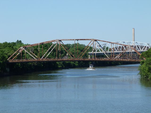
This bridge is one of two nearly identical bridges in Blue Island that are both deteriorated and closed to traffic. The reason for the deterioration appears to be caused by a nearly complete lack of maintenance, repair, and rehabilitation over the bridge's relatively short service life. From a historical perspective, the lack of maintenance is interesting since aside from the deterioration, the bridge appears as it was when first built. The original concrete deck remains, with only some minor patching for potholes. Original pedestrian railings remain, and typical of older truss bridges with sidewalks there are no railings between the truss lines and the vehicular roadway. Original stringer approach spans remain in place. Expansion joints also appear to be original. A bridge painted date is painted on the bridge as May 1965 which indicates the bridge has never been repainted since its initial painted. There also is no evidence of spot painting. It is this lack of even basic spot painting over the bridge's service life that most likely has led to the isolated areas of complete section loss on a number of vertical members. This bridge is thus an excellent unaltered example of a 1960s truss bridge as much as it is an excellent example of the value of basic maintenance such as spot painting, which would have been drastically cheaper than a rehabilitation would be, or even worse, a complete structure replacement.
Fortunately, the bridge was spared demolition and was rehabilitated for non-motorized traffic only. The below photos from Albert David show the bridge after rehab in 2016.
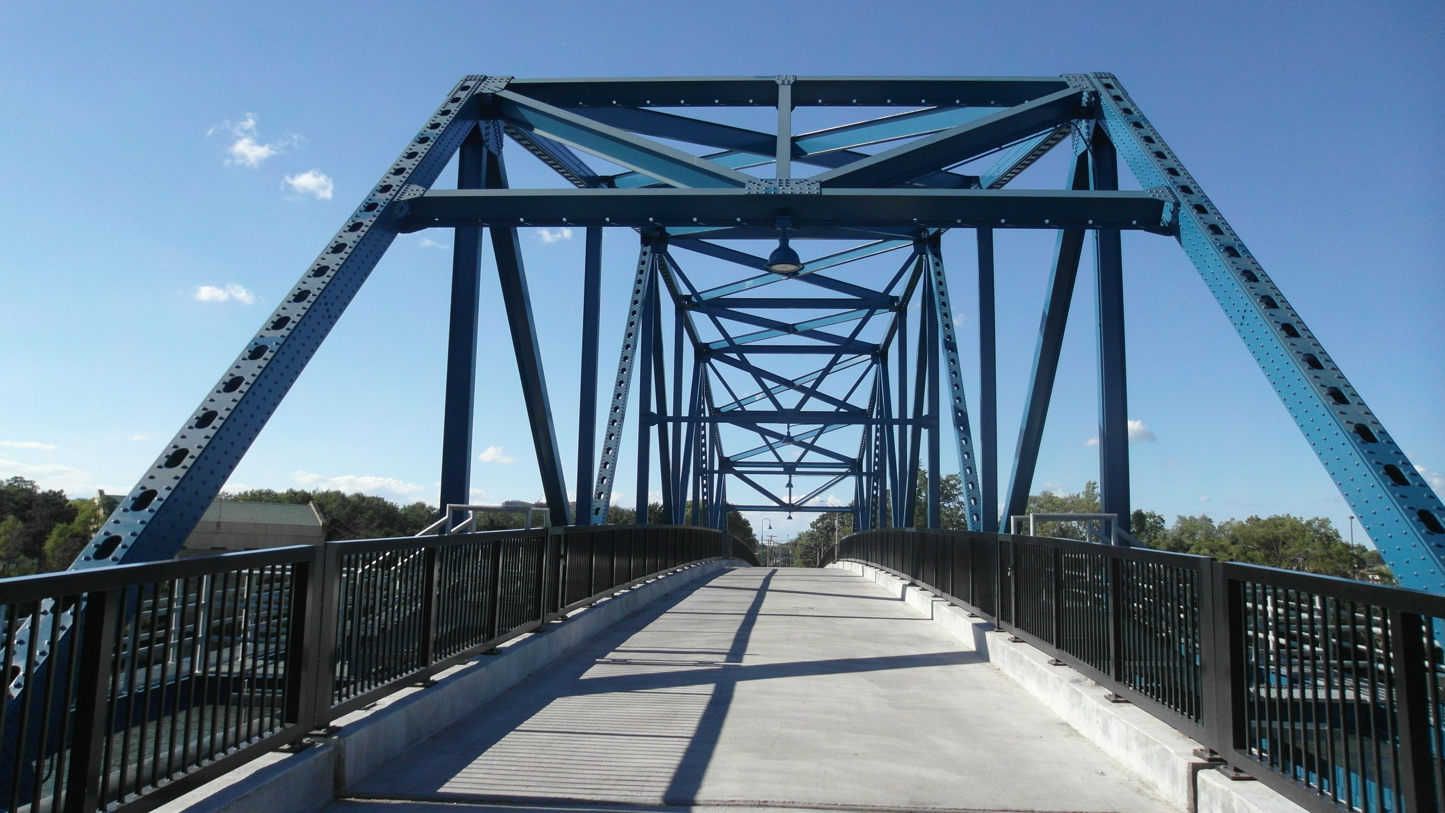


Above: Photos of rehabilitated bridge. Courtesy Albert David.
|
Original Plaque CHATHAM STREET BRIDGEBUILT 1964 BY STATE OF ILLINOIS C. H. ROUTE 259 SEC. 259 - 0404 - V, VB LOADING H20 - S16 |
![]()


Chicago and Cook County are home to one of the largest collections of historic bridges in the country, and no other city in the world has more movable bridges. HistoricBridges.org is proud to offer the most extensive coverage of historic Chicago bridges on the Internet.
General Chicago / Cook County Bridge Resources
Chicago's Bridges - By Nathan Holth, author of HistoricBridges.org, this book provides a discussion of the history of Chicago's movable bridges, and includes a virtual tour discussing all movable bridges remaining in Chicago today. Despite this broad coverage, the book is presented in a compact format that is easy to take with you and carry around for reference on a visit to Chicago. The book includes dozens of full color photos. Only $9.95 U.S! ($11.95 Canadian). Order Now Direct From The Publisher! or order on Amazon.
Chicago River Bridges - By Patrick T. McBriarty, this is a great companion to Holth's book shown above. This much larger book offers an extremely in-depth exploration of Chicago's movable highway bridges, including many crossings that have not existed for many years. Order Now Direct From The Publisher! or order on Amazon.
View Historic American Engineering Record (HAER) Overview of Chicago Bascule Bridges (HAER Data Pages, PDF)
Chicago Loop Bridges - Chicago Loop Bridges is another website on the Internet that is a great companion to the HistoricBridges.org coverage of the 18 movable bridges within the Chicago Loop. This website includes additional information such as connections to popular culture, overview discussions and essays about Chicago's movable bridges, additional videos, and current news and events relating to the bridges.
Additional Online Articles and Resources - This page is a large gathering of interesting articles and resources that HistoricBridges.org has uncovered during research, but which were not specific to a particular bridge listing.
![]()
![]()
![]()
Coordinates (Latitude, Longitude):
Search For Additional Bridge Listings:
Bridgehunter.com: View listed bridges within 0.5 miles (0.8 kilometers) of this bridge.
Bridgehunter.com: View listed bridges within 10 miles (16 kilometers) of this bridge.
Additional Maps:
Google Streetview (If Available)
GeoHack (Additional Links and Coordinates)
Apple Maps (Via DuckDuckGo Search)
Apple Maps (Apple devices only)
Android: Open Location In Your Map or GPS App
Flickr Gallery (Find Nearby Photos)
Wikimedia Commons (Find Nearby Photos)
Directions Via Sygic For Android
Directions Via Sygic For iOS and Android Dolphin Browser
USGS National Map (United States Only)
Historical USGS Topo Maps (United States Only)
Historic Aerials (United States Only)
CalTopo Maps (United States Only)

© Copyright 2003-2025, HistoricBridges.org. All Rights Reserved. Disclaimer: HistoricBridges.org is a volunteer group of private citizens. HistoricBridges.org is NOT a government agency, does not represent or work with any governmental agencies, nor is it in any way associated with any government agency or any non-profit organization. While we strive for accuracy in our factual content, HistoricBridges.org offers no guarantee of accuracy. Information is provided "as is" without warranty of any kind, either expressed or implied. Information could include technical inaccuracies or errors of omission. Opinions and commentary are the opinions of the respective HistoricBridges.org member who made them and do not necessarily represent the views of anyone else, including any outside photographers whose images may appear on the page in which the commentary appears. HistoricBridges.org does not bear any responsibility for any consequences resulting from the use of this or any other HistoricBridges.org information. Owners and users of bridges have the responsibility of correctly following all applicable laws, rules, and regulations, regardless of any HistoricBridges.org information.
![]()