


View Information About HSR Ratings
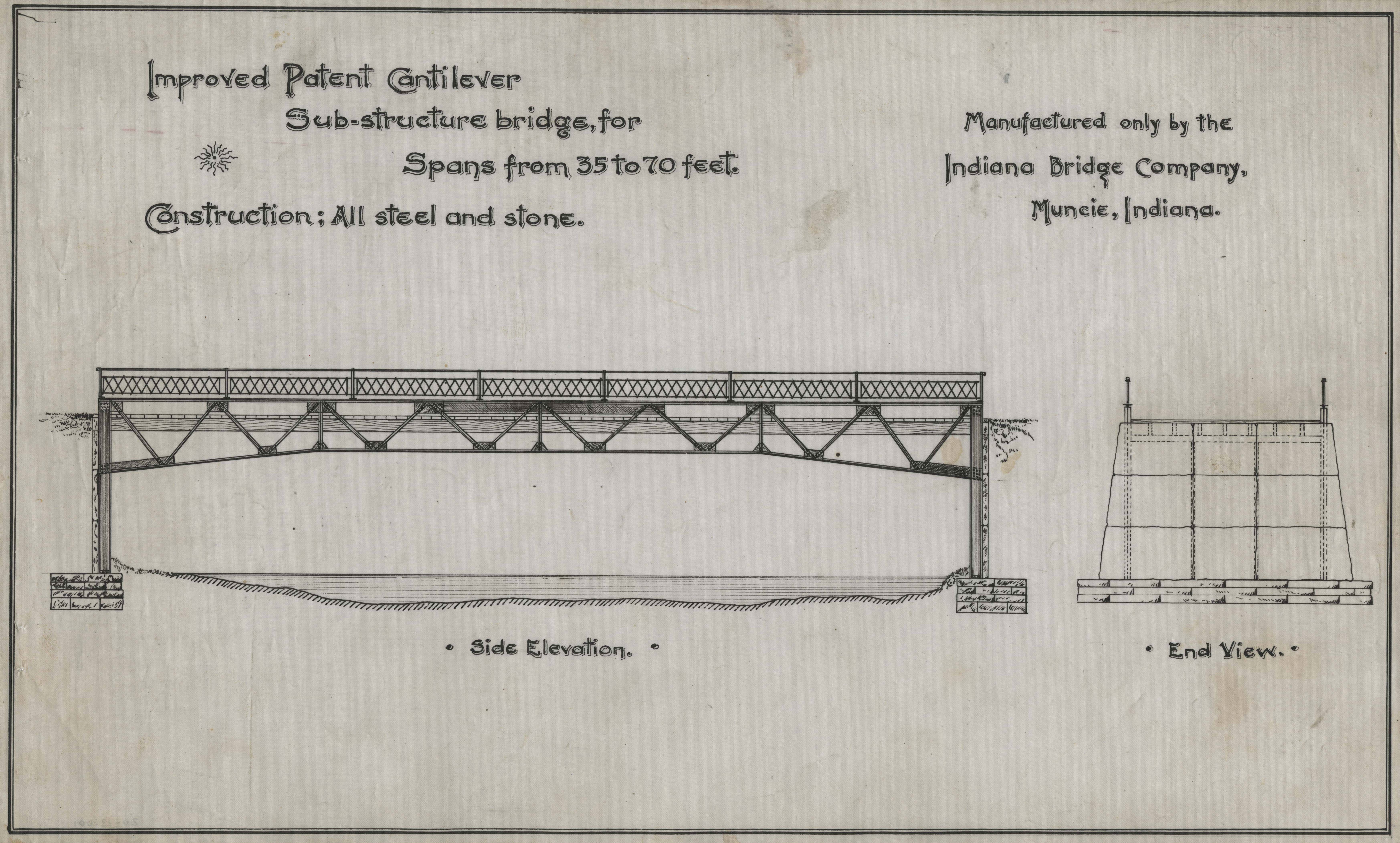
This bridge is the only known surviving example of an Indiana Bridge Company patented cantilever leg bridge. The bizarre bridge design is unlike anything every known to have been built by any other company. The design featured a Warren deck truss with a cantilevered design. The ends of the trusses were attached to legs that extended below the bottom chord to form a substructure, which is the bedstead aspect of the design. This bridge represents the design perfectly and a drawing from the Indiana Bridge Company shown below outlines a truss with the same member arrangement as this bridge. This bridge also features a historic rivet-connected Warren pony truss span. The two spans may have different histories, original locations, or construction date. For example, the pony truss may have been relocated to this site at a later date to replace a previous span. The exact history here is not known.
This bridge has been abandoned. The deck truss nature of the bedstead span is allowing flood debris to build up. The bridge is therefore at risk for destruction by floods. This is the last known example of a highly unusual patented bridge type. It should receive the highest preservation priority. This would be a good candidate for relocation and preservation in a new location, perhaps in a park or on a trail for pedestrian use only.
Indiana Bridge Company produced a number of unusual small-scale cantilever/bedstead bridge designs. Another example is a plate girder variation.

![]()
![]()
![]()
Coordinates (Latitude, Longitude):
Search For Additional Bridge Listings:
Bridgehunter.com: View listed bridges within 0.5 miles (0.8 kilometers) of this bridge.
Bridgehunter.com: View listed bridges within 10 miles (16 kilometers) of this bridge.
Additional Maps:
Google Streetview (If Available)
GeoHack (Additional Links and Coordinates)
Apple Maps (Via DuckDuckGo Search)
Apple Maps (Apple devices only)
Android: Open Location In Your Map or GPS App
Flickr Gallery (Find Nearby Photos)
Wikimedia Commons (Find Nearby Photos)
Directions Via Sygic For Android
Directions Via Sygic For iOS and Android Dolphin Browser
USGS National Map (United States Only)
Historical USGS Topo Maps (United States Only)
Historic Aerials (United States Only)
CalTopo Maps (United States Only)

© Copyright 2003-2025, HistoricBridges.org. All Rights Reserved. Disclaimer: HistoricBridges.org is a volunteer group of private citizens. HistoricBridges.org is NOT a government agency, does not represent or work with any governmental agencies, nor is it in any way associated with any government agency or any non-profit organization. While we strive for accuracy in our factual content, HistoricBridges.org offers no guarantee of accuracy. Information is provided "as is" without warranty of any kind, either expressed or implied. Information could include technical inaccuracies or errors of omission. Opinions and commentary are the opinions of the respective HistoricBridges.org member who made them and do not necessarily represent the views of anyone else, including any outside photographers whose images may appear on the page in which the commentary appears. HistoricBridges.org does not bear any responsibility for any consequences resulting from the use of this or any other HistoricBridges.org information. Owners and users of bridges have the responsibility of correctly following all applicable laws, rules, and regulations, regardless of any HistoricBridges.org information.
![]()