

View Information About HSR Ratings
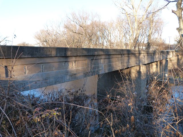
This three span bridge is a rare surviving example of a multi-span concrete through girder. Generally not built with span lengths beyond 60 feet, and generally reserved for small single-span river crossings, this bridge's three 54 foot spans are unusual. Deterioration has exposed part of a few reinforcing rods in the girders. The reinforcing rods are an old style, composed of twisted square bar. They are thoughtfully arranged within the concrete to address the forces the bridge experiances. For example, one of the exposed bars observed clearly runs at an angle (like a diagonal member in a truss bridge) through the concrete girder. The bridge has articulated floorbeams visible under the deck.
The bridge is closed to traffic and is slated for demolition and replacement despite its heritage value. The bridge's deck is the worst deteriorated part of the bridge, with a hole found in one part of the deck. The girders are in decent condition, with only isolated areas of spalling that has exposed reinforcing rods for the bridge.
The National Bridge Inventory gives a 1910 construction date for this bridge. This may be an incorrect date. 1910 has been assigned to other bridges in Grundy County where it was obvious that the date was wrong. 1910 would place the bridge as one of the oldest girder bridges in the state. The bridge has an appearance similar to other concrete girder bridges in Illinois, that usually date from 1916 onward.
![]()
![]()
![]()
This historic bridge has been demolished. This map is shown for reference purposes only.
Coordinates (Latitude, Longitude):
Search For Additional Bridge Listings:
Bridgehunter.com: View listed bridges within 0.5 miles (0.8 kilometers) of this bridge.
Bridgehunter.com: View listed bridges within 10 miles (16 kilometers) of this bridge.
Additional Maps:
Google Streetview (If Available)
GeoHack (Additional Links and Coordinates)
Apple Maps (Via DuckDuckGo Search)
Apple Maps (Apple devices only)
Android: Open Location In Your Map or GPS App
Flickr Gallery (Find Nearby Photos)
Wikimedia Commons (Find Nearby Photos)
Directions Via Sygic For Android
Directions Via Sygic For iOS and Android Dolphin Browser
USGS National Map (United States Only)
Historical USGS Topo Maps (United States Only)
Historic Aerials (United States Only)
CalTopo Maps (United States Only)

© Copyright 2003-2025, HistoricBridges.org. All Rights Reserved. Disclaimer: HistoricBridges.org is a volunteer group of private citizens. HistoricBridges.org is NOT a government agency, does not represent or work with any governmental agencies, nor is it in any way associated with any government agency or any non-profit organization. While we strive for accuracy in our factual content, HistoricBridges.org offers no guarantee of accuracy. Information is provided "as is" without warranty of any kind, either expressed or implied. Information could include technical inaccuracies or errors of omission. Opinions and commentary are the opinions of the respective HistoricBridges.org member who made them and do not necessarily represent the views of anyone else, including any outside photographers whose images may appear on the page in which the commentary appears. HistoricBridges.org does not bear any responsibility for any consequences resulting from the use of this or any other HistoricBridges.org information. Owners and users of bridges have the responsibility of correctly following all applicable laws, rules, and regulations, regardless of any HistoricBridges.org information.
![]()