We Recommend:
Bach Steel - Experts at historic truss bridge restoration.
BridgeHunter.com Phase 1 is released to the public! - Visit Now
30th Street Bridge
Marion County Bridge 1705, Riverside Park Bridge

Primary Photographer(s): Nathan Holth
Bridge Documented: July 2, 2021
Indianapolis: Marion County, Indiana: United States
1907 By Builder/Contractor: Marion County Construction Company and W.M. Fife and Son and Engineer/Design: Henry W. Klaussman
1979
116.0 Feet (35.4 Meters)
339.0 Feet (103.3 Meters)
50 Feet (15.24 Meters)
3 Main Span(s)
4900125

View Information About HSR Ratings
Bridge Documentation
This bridge no longer exists!
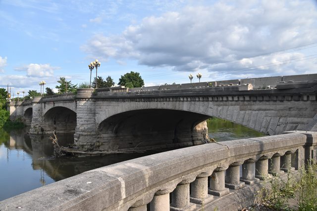
Bridge Status: Demolished and replaced.This beautiful stone faced concrete bridge with rare Melan reinforcing once formed the centerpiece to a park area. It is noted for its wide sidewalks (overall deck width is 72.5 feet) and its stairways (mostly overgrown and abandoned) that led down to the riverbank.
This bridge should have been preserved, as a Select bridge under the Indiana Historic Bridge Management Plan. However instead, demolition and replacement is the fate of this bridge, with salvage and reuse of non-structural decorative stones. The character-defining feature that gives the bridge its historical significance will be destroyed (nor will it be replicated in modern materials). That is the use of solid steel reinforcing called Melan reinforcing. It is disappointing that Indianapolis is repeatedly allowed to alter "Select" bridges in this manner. The bridge management plan was supposed to preserve historic bridges not build modern copies... and this won't even be a copy as modern rebar will be used.
On a side note, it was shocking how many sections of railing had been broken, presumably by traffic accidents. This was particularly odd given that this bridge has massive sidewalks that are perhaps twice as wide as even modern day sidewalks. If they were destroyed by accidents, people must drive like maniacs in this area!
It appears this bridge was listed as a contributing structure to a Historic District. It must not have been listed individually as a Melan arch. This appears to be how the city got around the loss of the Melan arch design. Bridges that are listed as contributing to a historic district, rather than individually listed under Criterion C (Engineering) can lose their engineering significance as long as they retain their aesthetic qualities. In truth the bridge should be individually eligible under Criterion C for its Melan arch construction.
View Archived National Bridge Inventory Report - Has Additional Details and Evaluation
This bridge is tagged with the following special condition(s): Melan
![]()
Photo Galleries and Videos: 30th Street Bridge
Bridge Photo-Documentation
Original / Full Size PhotosA collection of overview and detail photos. This gallery offers photos in the highest available resolution and file size in a touch-friendly popup viewer.
Alternatively, Browse Without Using Viewer
![]()
Bridge Photo-Documentation
Mobile Optimized PhotosA collection of overview and detail photos. This gallery features data-friendly, fast-loading photos in a touch-friendly popup viewer.
Alternatively, Browse Without Using Viewer
![]()
Maps and Links: 30th Street Bridge
This historic bridge has been demolished. This map is shown for reference purposes only.
Coordinates (Latitude, Longitude):
Search For Additional Bridge Listings:
Bridgehunter.com: View listed bridges within 0.5 miles (0.8 kilometers) of this bridge.
Bridgehunter.com: View listed bridges within 10 miles (16 kilometers) of this bridge.
Additional Maps:
Google Streetview (If Available)
GeoHack (Additional Links and Coordinates)
Apple Maps (Via DuckDuckGo Search)
Apple Maps (Apple devices only)
Android: Open Location In Your Map or GPS App
Flickr Gallery (Find Nearby Photos)
Wikimedia Commons (Find Nearby Photos)
Directions Via Sygic For Android
Directions Via Sygic For iOS and Android Dolphin Browser
USGS National Map (United States Only)
Historical USGS Topo Maps (United States Only)
Historic Aerials (United States Only)
CalTopo Maps (United States Only)

