We Recommend:
Bach Steel - Experts at historic truss bridge restoration.
BridgeHunter.com Phase 1 is released to the public! - Visit Now
Bond Cemetery Road Bridge
Brown County Bridge 36, Hickory Hill Road Bridge

Primary Photographer(s): Nathan Holth and Rick McOmber
Bridge Documented: September 23, 2012
Rural: Brown County, Indiana: United States
Metal 6 Panel Pin-Connected Pratt Through Truss, Fixed and Approach Spans: Metal Stringer (Multi-Beam), Fixed
1908 By Builder/Contractor: Pan American Bridge Company of New Castle, Indiana
Not Available or Not Applicable
87.0 Feet (26.5 Meters)
123.0 Feet (37.5 Meters)
12 Feet (3.66 Meters)
1 Main Span(s) and 1 Approach Span(s)
700028

View Information About HSR Ratings
Bridge Documentation
View Archived National Bridge Inventory Report - Has Additional Details and Evaluation
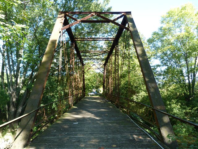
This bridge is a traditionally composed example of a pin-connected Pratt through truss. It has a-frame style portal bracing. It sits on steel caissons. The bridge has been closed to traffic. The Historic Bridge Inventory found that there was some interest in having the bridge reopened, perhaps for non-vehicular use. While it is still feasible to restore this bridge, the window of opportunity is fading. The bridge is severely deteriorated and the bridge is at an increasing risk for collapse. One of the plates that is part of the floorbeam and hanger system is cracked so badly it is split nearly in half. Many diagonal and vertical members have extremely severe section loss at the heads. Restoration of this bridge would likely need to include disassembly and restoration of these parts in a shop setting.
Information and Findings From DHPA Historic Bridge SurveyStatement of Significance Built by a prolific Indiana firm, this structure retains its original members and its decoratively latticed guardrails. Architectural Description The Pan-American Bridge Company of New Castle, Indiana, fabricated this single-span, pin-connected Pratt through truss and an I beam approach to the south. The bridge is seated upon metal abutments, wingwalls, and caisson pier. Intermediate verticals of laced channels subdivide the 90' through truss into most of its six panels. Eyebars provide the diagonals: pairs stretch toward center span from the top panel point to the bottom of all except the endpost panels; cylindrical eyebars with turnbuckles counter the others in the two most central panels. U-bolted to the lower pins, I floor beams carry the timber deck with its 11'6" roadway. Other Information Indiana Trail Riders are interested in getting this bridge re-opened per fax/letter from Chris Riehl to Mark Skirvin dated 5/4/07. Response from INDOT's March 2009 request to bridge owner to declare intent to re-open this closed bridge: No response received from bridge owner on future use; non-vehicular use with no plans to re-open assumed. Bridge Considered Historic By Survey: Yes |
![]()
Photo Galleries and Videos: Bond Cemetery Road Bridge
Bridge Photo-Documentation
Original / Full Size PhotosA collection of overview and detail photos. This gallery offers photos in the highest available resolution and file size in a touch-friendly popup viewer.
Alternatively, Browse Without Using Viewer
![]()
Bridge Photo-Documentation
Mobile Optimized PhotosA collection of overview and detail photos. This gallery features data-friendly, fast-loading photos in a touch-friendly popup viewer.
Alternatively, Browse Without Using Viewer
![]()
Maps and Links: Bond Cemetery Road Bridge
Coordinates (Latitude, Longitude):
Search For Additional Bridge Listings:
Bridgehunter.com: View listed bridges within 0.5 miles (0.8 kilometers) of this bridge.
Bridgehunter.com: View listed bridges within 10 miles (16 kilometers) of this bridge.
Additional Maps:
Google Streetview (If Available)
GeoHack (Additional Links and Coordinates)
Apple Maps (Via DuckDuckGo Search)
Apple Maps (Apple devices only)
Android: Open Location In Your Map or GPS App
Flickr Gallery (Find Nearby Photos)
Wikimedia Commons (Find Nearby Photos)
Directions Via Sygic For Android
Directions Via Sygic For iOS and Android Dolphin Browser
USGS National Map (United States Only)
Historical USGS Topo Maps (United States Only)
Historic Aerials (United States Only)
CalTopo Maps (United States Only)

