We Recommend:
Bach Steel - Experts at historic truss bridge restoration.
BridgeHunter.com Phase 1 is released to the public! - Visit Now
Briscoe Bridge
Yankeetown Road Bridge, Warrick County Bridge 271

Primary Photographer(s): Nathan Holth
Bridge Documented: May 27, 2019
Rural: Warrick County, Indiana: United States
Metal 8 Panel Pin-Connected Whipple (Double-Intersection Pratt) Through Truss, Fixed and Approach Spans: Metal 3 Panel Pin-Connected Kingpost Pony Truss,
1893 By Builder/Contractor: Wrought Iron Bridge Company of Canton, Ohio
2012
130.0 Feet (39.6 Meters)
206.4 Feet (62.9 Meters)
14.8 Feet (4.51 Meters)
1 Main Span(s) and 2 Approach Span(s)
8700123

View Information About HSR Ratings
Bridge Documentation
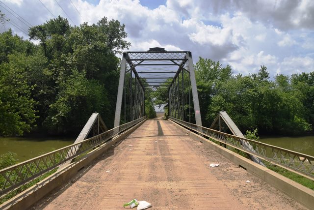
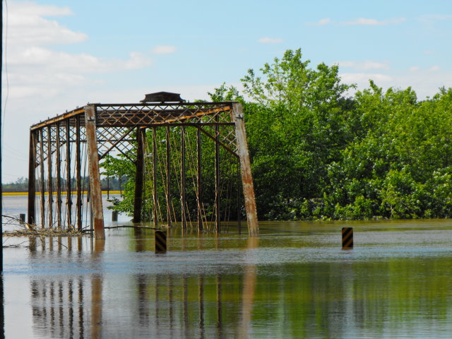
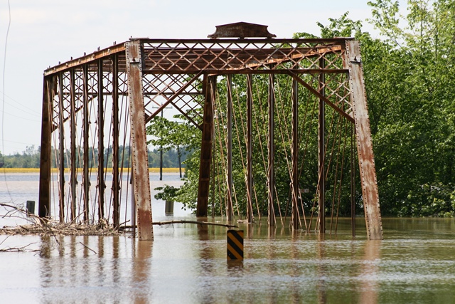
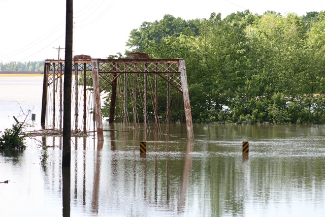
Some sources show this bridge as dating to ca. 1885, others show an 1893 construction date. This Whipple truss is unique due to its extremely rare Kingpost truss approach spans. Kingpost truss bridges are one of the rarest truss types in the country. They were quickly replaced by simple stringer bridges as a popular bridge type since they were so short. This bridge, featuring a combination of the rare Kingpost truss spans, one at each end, plus a Whipple truss main spam, itself a rare truss type, is a truly unique bridge. It has been preserved in place for continued vehicular use. While it is agreeable to see a bridge left in its original location, the decision was a bit risky. This bridge and the river it crosses is very close to the Ohio River and during flood events, backwater from the Ohio can rise high enough so as to rise far above the top of the Kingpost truss spans. These floodwaters can carry heavy objects. In the 2019 visit to this bridge, a small tree was lodged in the side of the Whipple truss span. Note that the two Kingpost truss spans are not identical, the southern span is a 20 foot span and the north span is a 30 foot span. The 20 foot span may be one of the shortest truss spans surviving in the entire country.
View Archived National Bridge Inventory Report - Has Additional Details and Evaluation
Above: A failed attempt by HistoricBridges.org to document the bridge on May 5, 2010 shows how flood waters can literally cover the Kingpost approach spans. This photo was taken prior to the bridge's most recent rehabilitation. Bottom two photos by Rick McOmber.
Information and Findings From DHPA Historic Bridge SurveyStatement of Significance Designed by a prolific and well-known Ohio firm, this structure is unusual in its combination of trusses. Whipples alone are not plentiful; Kingposts are quite rare; the combination is unique in Indiana. The trusses retain most of their original members including latticed guardrails and decoratively latticed portals and portal bracing on the main span. Including the only known extant pair of Kingpost ponies in the Middle West, this bridge has been judged by the county's consulting engineers as one of two "unusual" structures and by historical surveyors as "outstanding" enough to merit consideration for inclusion on the National Register of Historic Places. References MW, Inc., Warrick County Bridge Re-Inspection Report (Indianapolis, 1978). Engineer Associates, Inc., Bridge Reinspection Report: Warrick County (Evansville, 1981). United Consulting Engineers, Inc., Bridge Reinspection Report: Warrick County (Indianapolis, 1987). WTH Engineering, Warrick County: Bridge Reinspection Report (Indianapolis, 1999). bridge nameplate. Indiana Historic Sites & Structures Inventory, Gibson County and Warrick County: Interim Report (Indianapolis, 1984), 84. Architectural Description The Briscoe Bridge's superstructure is seated upon driven I-beams backed by timber for abutments under the I-beam approaches, intermediate girder piers under the pony-trusses, and metal caissons under the through span. The structure carries a timber deck with 16 feet of vertical roadway clearance over the center span. The Wrought Iron Bridge Company of Canton, Ohio, fabricated Briscoe Bridge's trusses. The pin-connected, double-intersection Pratt (Whipple) through trusses at the center of the structure span the creek. Laced channels compose the intermediate verticals which bound most of the eight panels. Most diagonals are double square eyebars; cylindrical ones with turnbuckles stretch from the three most central pins. The rectangular girder floor-beams are U-bolted to the lower pins. A pin-connected, Kingpost pony sits between an I-beam approach and the through-truss span on both sides. Each pony has a vertical of latticed Ts bolted through a cast iron top chord connector and riveted to pin plates below. The rectangular girder floor-beam is U-bolted to the pin. The ponies lack diagonals. Bridge Considered Historic By Survey: Yes |
![]()
Photo Galleries and Videos: Briscoe Bridge
Bridge Photo-Documentation
Original / Full Size PhotosA collection of overview and detail photos. This gallery offers photos in the highest available resolution and file size in a touch-friendly popup viewer.
Alternatively, Browse Without Using Viewer
![]()
Bridge Photo-Documentation
Mobile Optimized PhotosA collection of overview and detail photos. This gallery features data-friendly, fast-loading photos in a touch-friendly popup viewer.
Alternatively, Browse Without Using Viewer
![]()
Maps and Links: Briscoe Bridge
Coordinates (Latitude, Longitude):
Search For Additional Bridge Listings:
Bridgehunter.com: View listed bridges within 0.5 miles (0.8 kilometers) of this bridge.
Bridgehunter.com: View listed bridges within 10 miles (16 kilometers) of this bridge.
Additional Maps:
Google Streetview (If Available)
GeoHack (Additional Links and Coordinates)
Apple Maps (Via DuckDuckGo Search)
Apple Maps (Apple devices only)
Android: Open Location In Your Map or GPS App
Flickr Gallery (Find Nearby Photos)
Wikimedia Commons (Find Nearby Photos)
Directions Via Sygic For Android
Directions Via Sygic For iOS and Android Dolphin Browser
USGS National Map (United States Only)
Historical USGS Topo Maps (United States Only)
Historic Aerials (United States Only)
CalTopo Maps (United States Only)


