

View Information About HSR Ratings
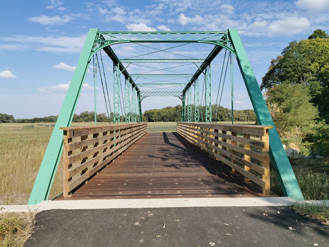
This outstanding King Bridge Company Pratt truss bridge was carefully restored and relocated to a park setting for pedestrian use. It is formally listed on the National Register of Historic Places.
The bridge was restored in-kind with a careful attention paid to maintaining the historic integrity of the trusses. The beautiful riveted fishbelly floorbeams were repaired and retained on the bridge. Restoration was done by Bach Steel.
This bridge has an outstanding interpretive sign installed that tells the history and design of the bridge, and describes its relocation and restoration as well. It is an outstanding sign that sets a good example for other projects to follow.
The previous location of this bridge was over Buck Creek on CR 875 West (39.622607, -85.947769).
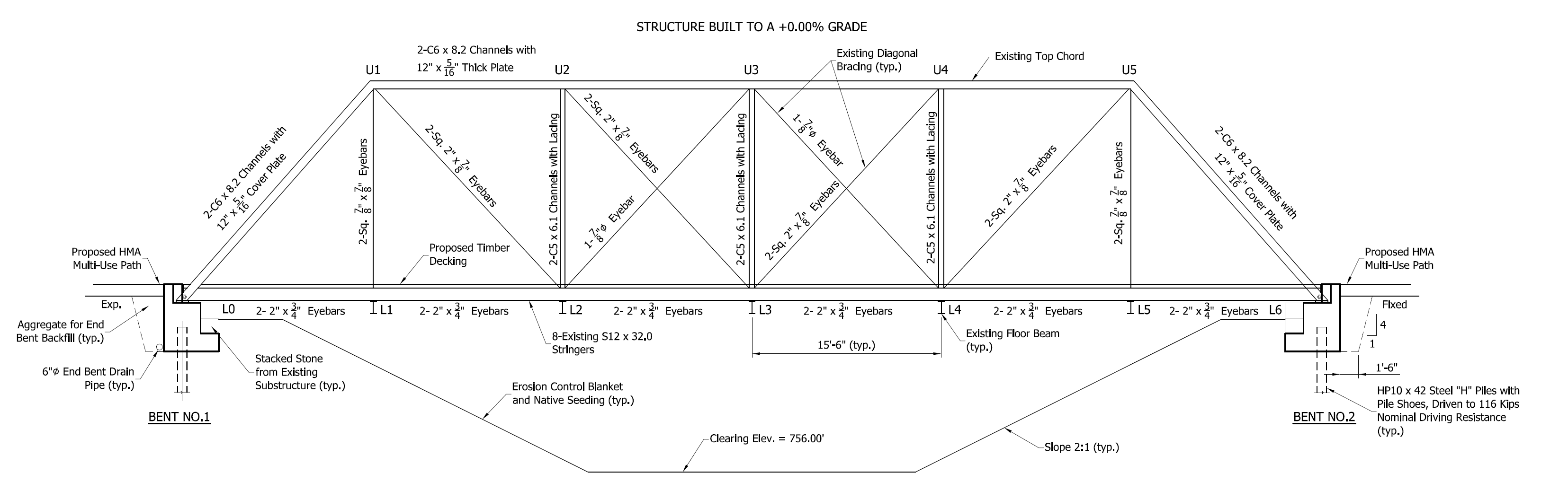
Above: Bridge as shown in rehabilitation plans showing dimensions of members and chords.

Above: Historical photo from Dr. James Cooper showing bridge in its previous location.
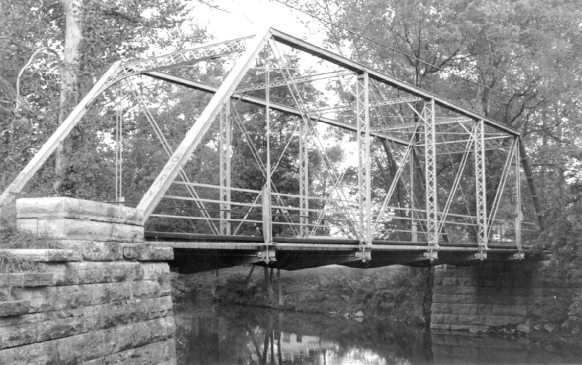
Above: Historical photo from Dr. James Cooper showing bridge in its previous location.
Information and Findings From DHPA Historic Bridge SurveyBridge History and Significance In early April 1889, the Shelby county commissioners paid Thomas Finley $68 "for services as engineer on bridge near Brookfield." In May, the board contracted for the construction of a structure at Clover Ford of Buck Creek, 1.25 miles southwest of Brookfield in Moral township. William F. Loyd won the masonry contract at $440 for timber and excavation and $6.60 per cubic yard for stonework. The proposal of the King Iron Bridge & Manufacturing Company of Cleveland, Ohio, for a "wrought-iron" superstructure at $1,190 won out. The structure was to have a 90-foot clear span and 94-foot in full length with a 16-foot roadway. The 9 runs of stringers and the riding surface were to be of timber. To their contract with King Bridge, the commissioners added the provision that "any defect in the sizes, quality or weight in said superstructure herein provided for shall operate as a forfeiture of 25% of above contract price for said entire structure." The King Bridge Company received 60% of its contract price in early September. Payments to Loyd of &640, $341, and $800 came in October and November. Payments of $25 and $183 to D. W. Avery and to William Avery of $100 in this same period may have been for stone that Loyd used. C. A. House was paid $18, B. F. Belton $12, and William Borden $7.50 for moving stone to the Buck Creek site. B. F. Belton provided fill, and W. F. Loyd installed rip-rap in early 1890. The wrought-iron superstructure is seated upon limestone abutments and wingwalls. Intermediate verticals of two sizes of laced channels subdivide the pinned Pratt trusses into most of their six panels. Eyebars provide the diagonals: pairs stretch toward center span from the top panel point to the bottom of all except the endpost panels; cylindrical eyebars with turnbuckles counter the others in the two most central panels. U-bolted to the lower pins, variable-depth girder floor-beams carry the deck. Runs of steel stringers now support a steel-grate riding surface which allows for 14 feet and 5 inches of vertical clearance. The trusses retain their original members. The original latticed portals and decorated portal bracing, lateral bracing and struts, and floor-beams are also intact. References Butler, Fairman and Seufert, Inc., Bridge Inspection Report: Shelby County (Indianapolis, 1973). United Consulting Engineers, Inc., Bridge Reinspection Report For Shelby County (Indianapolis, 1978). Indiana Historic Sites and Structures Inventory, Shelby County: Interim Report (Indianapolis, 1992), 17, 20. Shelby County, "Commissioners Record," K: 272, 277-281, 362, 381-382, 396, 430, 441, 444. Bridge Considered Historic By Survey: Yes |
![]()
![]()
![]()
Coordinates (Latitude, Longitude):
Search For Additional Bridge Listings:
Bridgehunter.com: View listed bridges within 0.5 miles (0.8 kilometers) of this bridge.
Bridgehunter.com: View listed bridges within 10 miles (16 kilometers) of this bridge.
Additional Maps:
Google Streetview (If Available)
GeoHack (Additional Links and Coordinates)
Apple Maps (Via DuckDuckGo Search)
Apple Maps (Apple devices only)
Android: Open Location In Your Map or GPS App
Flickr Gallery (Find Nearby Photos)
Wikimedia Commons (Find Nearby Photos)
Directions Via Sygic For Android
Directions Via Sygic For iOS and Android Dolphin Browser
USGS National Map (United States Only)
Historical USGS Topo Maps (United States Only)
Historic Aerials (United States Only)
CalTopo Maps (United States Only)

© Copyright 2003-2026, HistoricBridges.org. All Rights Reserved. Disclaimer: HistoricBridges.org is a volunteer group of private citizens. HistoricBridges.org is NOT a government agency, does not represent or work with any governmental agencies, nor is it in any way associated with any government agency or any non-profit organization. While we strive for accuracy in our factual content, HistoricBridges.org offers no guarantee of accuracy. Information is provided "as is" without warranty of any kind, either expressed or implied. Information could include technical inaccuracies or errors of omission. Opinions and commentary are the opinions of the respective HistoricBridges.org member who made them and do not necessarily represent the views of anyone else, including any outside photographers whose images may appear on the page in which the commentary appears. HistoricBridges.org does not bear any responsibility for any consequences resulting from the use of this or any other HistoricBridges.org information. Owners and users of bridges have the responsibility of correctly following all applicable laws, rules, and regulations, regardless of any HistoricBridges.org information.
![]()