

View Information About HSR Ratings
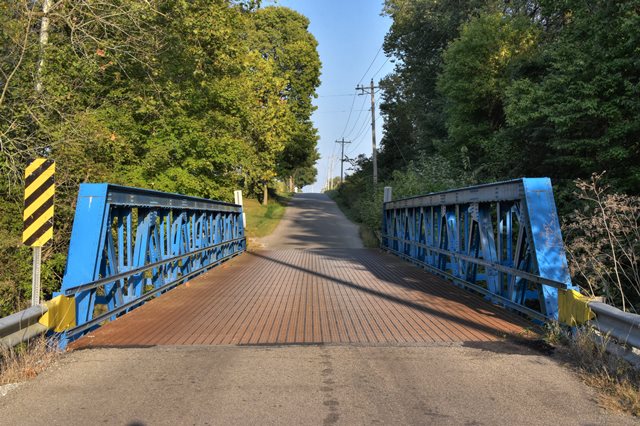
This state standard pony truss bridge has been nicely painted in a vibrant blue.
Information and Findings From DHPA Historic Bridge SurveyBridge History and Significance Previous Structure In June 1892, the Shelby county board of commissioners contracted with the Indiana Bridge Company of Muncie, Indiana, to erect a 16-foot high Pratt through-truss structure extending 87-feet in seven panels with a 14-foot roadway for $1,225 over Conns Creek, about 1.5 miles southwest of Waldron. Haymond and Howard received a $1,016 contract to reinforce the floor of this bridge in October 1912. This structure may have been washed out in the great spring flood of 1913. Surveyed Structure Concrete abutments and wingwalls support the single-span Warren pony truss. The riveted structure extends 87'6" in seven panels. Its all-interior verticals are manufactured from pairs of angles riveted together with stay plates and reinforced with external sway bracing. Its diagonals are made from a pair of angles (doubled in the outer panel) also riveted together with stay plates. The I floor-beams are riveted to gussets and the verticals above the lower chord and carry the concrete deck. The weight and varied size of the diagonals, the placement of the floor-beams, and the integration of knee or external sway braces into the verticals indicate a late stage in the design of all-riveted Warren pony trusses. This altogether undecorated bridge retains its original members. References Previous Structure Indiana Bridge Company, "Contract Index," #734. Shelby County, "Commissioners Record," L: 387; S: 189. Surveyed Structure Butler, Fairman and Seufert, Inc., Bridge Inspection Report: Shelby County (Indianapolis, 1973). United Consulting Engineers, Inc., Bridge Reinspection Report For Shelby County (Indianapolis, 1978). SIECO, Inc., Bridge Reinspection Report: Shelby County (Columbus, 1990, 1994). Indiana Historic Sites and Structures Inventory, Shelby County: Interim Report (Indianapolis, 1992), 99-100. Bridge Considered Historic By Survey: Yes |
![]()
![]()
![]()
Coordinates (Latitude, Longitude):
Search For Additional Bridge Listings:
Bridgehunter.com: View listed bridges within 0.5 miles (0.8 kilometers) of this bridge.
Bridgehunter.com: View listed bridges within 10 miles (16 kilometers) of this bridge.
Additional Maps:
Google Streetview (If Available)
GeoHack (Additional Links and Coordinates)
Apple Maps (Via DuckDuckGo Search)
Apple Maps (Apple devices only)
Android: Open Location In Your Map or GPS App
Flickr Gallery (Find Nearby Photos)
Wikimedia Commons (Find Nearby Photos)
Directions Via Sygic For Android
Directions Via Sygic For iOS and Android Dolphin Browser
USGS National Map (United States Only)
Historical USGS Topo Maps (United States Only)
Historic Aerials (United States Only)
CalTopo Maps (United States Only)

© Copyright 2003-2026, HistoricBridges.org. All Rights Reserved. Disclaimer: HistoricBridges.org is a volunteer group of private citizens. HistoricBridges.org is NOT a government agency, does not represent or work with any governmental agencies, nor is it in any way associated with any government agency or any non-profit organization. While we strive for accuracy in our factual content, HistoricBridges.org offers no guarantee of accuracy. Information is provided "as is" without warranty of any kind, either expressed or implied. Information could include technical inaccuracies or errors of omission. Opinions and commentary are the opinions of the respective HistoricBridges.org member who made them and do not necessarily represent the views of anyone else, including any outside photographers whose images may appear on the page in which the commentary appears. HistoricBridges.org does not bear any responsibility for any consequences resulting from the use of this or any other HistoricBridges.org information. Owners and users of bridges have the responsibility of correctly following all applicable laws, rules, and regulations, regardless of any HistoricBridges.org information.
![]()