We Recommend:
Bach Steel - Experts at historic truss bridge restoration.
BridgeHunter.com Phase 1 is released to the public! - Visit Now
CR-1225 North Bridge
Jennings County Bridge 50

Primary Photographer(s): Nathan Holth and Rick McOmber
Bridge Documented: September 22, 2012
Rural: Jennings County, Indiana: United States
1895 By Builder/Contractor: Wrought Iron Bridge Company of Canton, Ohio
Not Available or Not Applicable
60.0 Feet (18.3 Meters)
62.0 Feet (18.9 Meters)
15.7 Feet (4.79 Meters)
1 Main Span(s)
4000048

View Information About HSR Ratings
Bridge Documentation
View Archived National Bridge Inventory Report - Has Additional Details and Evaluation
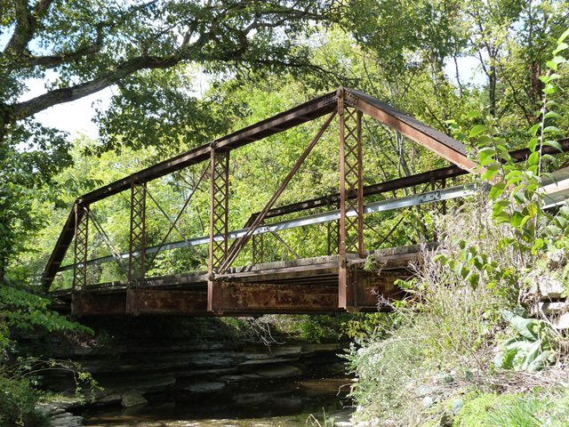
Some names we find in roads and rivers make little sense today. However, Flatrock Creek is appropriately named. The creek is lined with flat rocks as it passes under the bridge. Indeed, one very unusual aspect of this bridge is that it does not have built abutments and instead simply rests on the rock.
Although no plaque survives, this bridge appears to be the work of the Wrought Iron Bridge Company. The reason for this assessment is the cast iron bridge shoes with part numbers cast into them that accept a threaded rod with nut style connection for the bottom chord, combined with the use of pairs of rolled t's with lattice for the vertical members.
The bridge has some other noteworthy details. The floorbeams are built-up. Small, possibly cast iron wedge-shaped washers are found above the hanger bolts. The lateral bracing connections to the floor beams also include unusual cast iron washers.
Information and Findings From DHPA Historic Bridge SurveyStatement of Significance Aside from the design of the verticals and the adjustability of all diagonals, the other members of this Pratt pony span are rather standard for an early pinned structure. The absence of a man-made substructure is noteworthy. The original members of the unadorned bridge still function. Architectural Description This single-span Pratt pony truss rests upon bedrock. It has no man-made substructure. The pin-connected structure extends 61'8" in five panels. Its verticals are fabricated from laced Ts. All the diagonals and counters are made from cylindrical rods and adjust. A pair of rods supply the outer diagonals; a single rod provides the diagonal and counter in the center panel. Girder floor beams, which are U-bolted to the lower pins, carry the concrete deck with its 15'10" roadway. Bridge Considered Historic By Survey: Yes |
![]()
Photo Galleries and Videos: CR-1225 North Bridge
Bridge Photo-Documentation
Original / Full Size PhotosA collection of overview and detail photos. This gallery offers photos in the highest available resolution and file size in a touch-friendly popup viewer.
Alternatively, Browse Without Using Viewer
![]()
Bridge Photo-Documentation
Mobile Optimized PhotosA collection of overview and detail photos. This gallery features data-friendly, fast-loading photos in a touch-friendly popup viewer.
Alternatively, Browse Without Using Viewer
![]()
Eastbound Crossing
Full Motion VideoStreaming video of the bridge. Also includes a higher quality downloadable video for greater clarity or offline viewing.
![]()
Maps and Links: CR-1225 North Bridge
Coordinates (Latitude, Longitude):
Search For Additional Bridge Listings:
Bridgehunter.com: View listed bridges within 0.5 miles (0.8 kilometers) of this bridge.
Bridgehunter.com: View listed bridges within 10 miles (16 kilometers) of this bridge.
Additional Maps:
Google Streetview (If Available)
GeoHack (Additional Links and Coordinates)
Apple Maps (Via DuckDuckGo Search)
Apple Maps (Apple devices only)
Android: Open Location In Your Map or GPS App
Flickr Gallery (Find Nearby Photos)
Wikimedia Commons (Find Nearby Photos)
Directions Via Sygic For Android
Directions Via Sygic For iOS and Android Dolphin Browser
USGS National Map (United States Only)
Historical USGS Topo Maps (United States Only)
Historic Aerials (United States Only)
CalTopo Maps (United States Only)


