

View Information About HSR Ratings
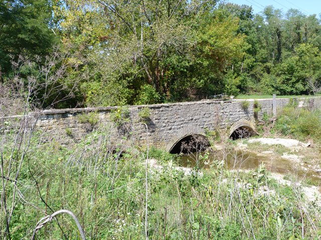
Although this bridge has four spans, the low rise of the arches and the shortness of these spans make this a small, low-lying bridge. The bridge's stone spandrel walls appear to retain historic integrity, but the arch ring has been altered by the addition of concrete and later a corrugated steel lining as well.
Information and Findings From DHPA Historic Bridge SurveyStatement of Significance Stone arches were not typically designed with segmental rings. Few of Decatur County's segmental stone arches are multispan and fewer yet have so little rise. Architectural Description Local craftsmen built most of Indiana's stone arches from regional materials just before or in the first fifteen years of the twentieth century. Most stonemasons preferred full-centered or semicircular arches in
which the line of pressure passes through the center of each stone in the arch ring until carried vertically into the substructure. In some cases, though, masons erected segmental arches in which the intrados is less than half a
circle. To function successfully, segmental arches require the substructure to accommodate some horizontal as well as some vertical pressure. Other Information In March 1872, the Decatur board appropriated $500 as a contribution to the Sand Creek Turnpike Company to aid in "constructing a bridge across Sand Creek on their road." The appropriation could have applied to
#114, #118, or #190. It is unclear whether local citizens in the early twentieth century considered #114 or #117 as the "Harris City Bridge." In any case, J. M. Mathews received $30 for repairing the bridge's wingwalls of the bridge
near Harris City in June 1908. In response to damages inflicted by the big 1913 flood, the commissioners accepted the plans and specifications which "J. A. Stagg, Engineer," submitted for "reconstruction of a wall" and fill of the
"Harris city bridge." McQueen and Watkins secured a $267 contract for the repair in May, and the county paid them in December. The arch rings are low and quite segmental. They are also placed under considerable fill. Bridge Considered Historic By Survey: Yes |
![]()
![]()
![]()
Coordinates (Latitude, Longitude):
Search For Additional Bridge Listings:
Bridgehunter.com: View listed bridges within 0.5 miles (0.8 kilometers) of this bridge.
Bridgehunter.com: View listed bridges within 10 miles (16 kilometers) of this bridge.
Additional Maps:
Google Streetview (If Available)
GeoHack (Additional Links and Coordinates)
Apple Maps (Via DuckDuckGo Search)
Apple Maps (Apple devices only)
Android: Open Location In Your Map or GPS App
Flickr Gallery (Find Nearby Photos)
Wikimedia Commons (Find Nearby Photos)
Directions Via Sygic For Android
Directions Via Sygic For iOS and Android Dolphin Browser
USGS National Map (United States Only)
Historical USGS Topo Maps (United States Only)
Historic Aerials (United States Only)
CalTopo Maps (United States Only)

© Copyright 2003-2026, HistoricBridges.org. All Rights Reserved. Disclaimer: HistoricBridges.org is a volunteer group of private citizens. HistoricBridges.org is NOT a government agency, does not represent or work with any governmental agencies, nor is it in any way associated with any government agency or any non-profit organization. While we strive for accuracy in our factual content, HistoricBridges.org offers no guarantee of accuracy. Information is provided "as is" without warranty of any kind, either expressed or implied. Information could include technical inaccuracies or errors of omission. Opinions and commentary are the opinions of the respective HistoricBridges.org member who made them and do not necessarily represent the views of anyone else, including any outside photographers whose images may appear on the page in which the commentary appears. HistoricBridges.org does not bear any responsibility for any consequences resulting from the use of this or any other HistoricBridges.org information. Owners and users of bridges have the responsibility of correctly following all applicable laws, rules, and regulations, regardless of any HistoricBridges.org information.
![]()