We Recommend:
Bach Steel - Experts at historic truss bridge restoration.
BridgeHunter.com Phase 1 is released to the public! - Visit Now
DeArmond Ford Bridge
Decatur County Bridge 116

Primary Photographer(s): Nathan Holth and Rick McOmber
Bridge Documented: September 22, 2012
Rural: Decatur County, Indiana: United States
Not Available or Not Applicable
28.5 Feet (8.7 Meters)
87.0 Feet (26.5 Meters)
15.7 Feet (4.79 Meters)
3 Main Span(s)
1600094

View Information About HSR Ratings
Bridge Documentation
View Archived National Bridge Inventory Report - Has Additional Details and Evaluation
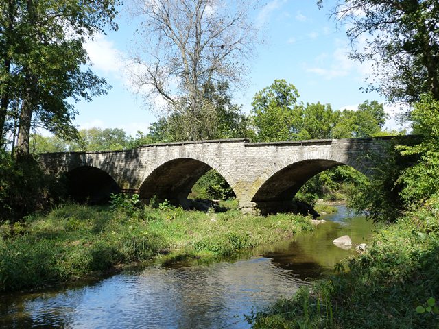
This is an attractive example of a stone arch bridge. With three spans, the center span is one foot longer and slightly taller than the end spans. The bridge is largely unaltered. It stands out among the many surviving stone arch bridges in this area for its lack of alteration and decent length.
Information and Findings From DHPA Historic Bridge SurveyStatement of Significance This bridge pushes the conventions used with the typical stone arches built in the state's south-central counties. Although they are close to being semicircular, the rings are actually, if cautiously, segmental. Architectural Description Local craftsmen built most of Indiana's stone arches from regional materials just before or in the first fifteen years of the twentieth century. Following a few simple rules of thumb that had evolved since Roman
days, stonemasons erected full-centered or semicircular arches in which the line of pressure passes through the center of each stone in the arch ring until carried vertically into the substructure. Most of the state's stone arches
span streams in south-central counties. With more than two dozen extant, Decatur County built the largest number. By World War I, the growing popularity of concrete, which engineers could readily adjust to the special needs of each
specific bridge site, quietly ended most stone arch construction in the region. Other Information The Decatur county commissioners ordered J. W. Craig in May 1902 to prepare estimates for a stone-arch bridge across Sand Creek at DeArmond Ford near Union Church in Sandcreek township. The county council appropriated $1,500 for construction in September. Letting a contract for a three-span stone arch did not occur until April 1903, at which time Hodson was the lowest and best bidder at $1,431, sufficiently under the estimate and appropriation to be successful. Hodson received partial payments in August and September that added up to almost the contracted figure. Bridge Considered Historic By Survey: Yes |
![]()
Photo Galleries and Videos: DeArmond Ford Bridge
Bridge Photo-Documentation
Original / Full Size PhotosA collection of overview and detail photos. This gallery offers photos in the highest available resolution and file size in a touch-friendly popup viewer.
Alternatively, Browse Without Using Viewer
![]()
Bridge Photo-Documentation
Mobile Optimized PhotosA collection of overview and detail photos. This gallery features data-friendly, fast-loading photos in a touch-friendly popup viewer.
Alternatively, Browse Without Using Viewer
![]()
Maps and Links: DeArmond Ford Bridge
Coordinates (Latitude, Longitude):
Search For Additional Bridge Listings:
Bridgehunter.com: View listed bridges within 0.5 miles (0.8 kilometers) of this bridge.
Bridgehunter.com: View listed bridges within 10 miles (16 kilometers) of this bridge.
Additional Maps:
Google Streetview (If Available)
GeoHack (Additional Links and Coordinates)
Apple Maps (Via DuckDuckGo Search)
Apple Maps (Apple devices only)
Android: Open Location In Your Map or GPS App
Flickr Gallery (Find Nearby Photos)
Wikimedia Commons (Find Nearby Photos)
Directions Via Sygic For Android
Directions Via Sygic For iOS and Android Dolphin Browser
USGS National Map (United States Only)
Historical USGS Topo Maps (United States Only)
Historic Aerials (United States Only)
CalTopo Maps (United States Only)

