

View Information About HSR Ratings
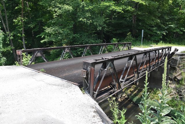
This is the most unusual of a unique group of six historic truss bridges found along this road. The trusses no longer function as anything olther than decorations, with load bearing beams added. However the shallow trusses with vertical endposts are extremely unusual. The bridge is noted as a bedstead bridge with its legs encased in concrete. The bedstead design only makes this bridge more unusual. The lack of vertical members in this Warren truss is also unusual.
One of the endposts of the bridge has been badly damaged by a vehicle impact. Further, this bridge was apparantly hit again a few weeks after these photos were taken, and the bridge is now closed to all traffic.
The truss is mostly fastened with rivets, but some connections display bolts as well.
Construction date is an estimate.
Information and Findings From DHPA Historic Bridge SurveyBridge History and Significance The truss legs of this 40', single-span Warren bedstead pony are seated behind concrete abutments and wingwalls and once successfully dispersed the tension and compression of the crossing. Now a pair of 24" I beams set on the abutments above the truss bear all the stresses. The largely-bolted bedstead consists of six panels and has no verticals. The top chord was fabricated from single angles laced together and the diagonals and lower chord members of single angles riveted together with stay plates. Bolted to gussets, the I floor-beams once carried the timber deck with its 12'8" roadway. While erected with some frequency in Martin County, Warren truss legs are far less common and a later development than the Pratts. This one was unusually designed, especially with the omission of verticals and the lighter-than-usual top chord. Although no longer functioning as a truss, the bedstead retains its original members. References American Consulting Engineers, Inc., Bridge Inspection/Reinspection Report: Martin County (Indianapolis, 1974, 1979). Bridge Considered Historic By Survey: Yes |
![]()
![]()
![]()
Coordinates (Latitude, Longitude):
Search For Additional Bridge Listings:
Bridgehunter.com: View listed bridges within 0.5 miles (0.8 kilometers) of this bridge.
Bridgehunter.com: View listed bridges within 10 miles (16 kilometers) of this bridge.
Additional Maps:
Google Streetview (If Available)
GeoHack (Additional Links and Coordinates)
Apple Maps (Via DuckDuckGo Search)
Apple Maps (Apple devices only)
Android: Open Location In Your Map or GPS App
Flickr Gallery (Find Nearby Photos)
Wikimedia Commons (Find Nearby Photos)
Directions Via Sygic For Android
Directions Via Sygic For iOS and Android Dolphin Browser
USGS National Map (United States Only)
Historical USGS Topo Maps (United States Only)
Historic Aerials (United States Only)
CalTopo Maps (United States Only)

© Copyright 2003-2026, HistoricBridges.org. All Rights Reserved. Disclaimer: HistoricBridges.org is a volunteer group of private citizens. HistoricBridges.org is NOT a government agency, does not represent or work with any governmental agencies, nor is it in any way associated with any government agency or any non-profit organization. While we strive for accuracy in our factual content, HistoricBridges.org offers no guarantee of accuracy. Information is provided "as is" without warranty of any kind, either expressed or implied. Information could include technical inaccuracies or errors of omission. Opinions and commentary are the opinions of the respective HistoricBridges.org member who made them and do not necessarily represent the views of anyone else, including any outside photographers whose images may appear on the page in which the commentary appears. HistoricBridges.org does not bear any responsibility for any consequences resulting from the use of this or any other HistoricBridges.org information. Owners and users of bridges have the responsibility of correctly following all applicable laws, rules, and regulations, regardless of any HistoricBridges.org information.
![]()