

View Information About HSR Ratings

Above: Builder plaque from Historic American Engineering Record Documentation
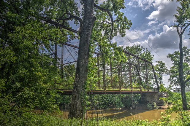
Information and Findings From DHPA Historic Bridge SurveyBridge History and Significance William F. T. McKee operated a ferry at this location from around the opening of the canal in 1850 until 1878 when Muehler and Notter built a wooden bridge for $8,700. After the timber structure burned at night in July of 1893, the county contracted for a wrought iron span to be set atop the stone abutments Muehler and Notter had built. The C. F. Hunt Company of Indianapolis secured the job for $5,000 in September 1894 and completed the new superstructure by early 1895. C. F. Hunt and J. D. Adams started as partners as early as 1888 in building and selling road machinery and bridges, and they continued under shifting arrangements for more than a decade. In 1894, C. F. Hunt organized a company under his own name, in which he served as foreman, and advertised as "bridge builders." The company existed until at least 1901. The commissioners ordered repairs to the Feeder Dam bridge in 1907-1908. In August 1908, Ed Grimes was paid $80 for painting the bridge. E. J. Schauwecker won a contract for $357 in September 1913 to refloor the bridge and rebolt the fellow guards. The Hunt Company fabricated a double-intersection Pratt (Whipple) through-truss span. Astride its original cut stone abutments, this high, long (204'), and decorated structure contains eleven panels with intermediate verticals of two sizes of latticed channels (outer as heavier) riveted to pin plates above and reinforcing pin plates below. The upper pins of the two central verticals carry cylindrical diagonals with turnbuckles. Most other diagonals are die-forged eyebars pinned to the vertical as it passes through at about midpoint. The high trusses carry a latticed portal strut and laced interior ones at the upper panel points. They also carry intermediate struts which effectively reduce vertical clearance to 15'5": latticed with curved bracing at the portals; I-bars on the interior. Double U-bolted to the lower pins, the I floor-beams support the asphalt-over-timber deck which provides an 18'3" roadway. "Latticed hub guards" line the trusses. Finials and cresting above the portals also add a touch of elegance to the bridge. The only surviving example of this secondary Hoosier builder, this truss retains its original members and much of its decoration. The practice of intermediate pinning of diagonals seen here is quite unusual. References Beam, Longest & Neff, Inc., Bridge Inventory Rating and Safety Inspection: Clay County (Indianapolis, 1973, 1979). bridge nameplate. Clay County, "Commissioners Record," 13: 438, 451-452; 14: 51, 458-460; 24: 2, 6; 26: 442. "Index to Commissioners Record," 23: 376, 525, 547. "Commissioners Docket," 5: 11 Jan., 9 April 1895. Consolidated Illustrating Co., Indianapolis of Today (Indianapolis, 1896), 175. HAER IN-21 (13 photos, 1974). Thomas Slade (ed.), Historic American Buildings Survey in Indiana (Bloomington, 1983), 131. William Travis, History of Clay County (Chicago, 1909), I: 67-69, 80. Bridge Considered Historic By Survey: Yes |
![]()
![]()
![]()
Coordinates (Latitude, Longitude):
Search For Additional Bridge Listings:
Bridgehunter.com: View listed bridges within 0.5 miles (0.8 kilometers) of this bridge.
Bridgehunter.com: View listed bridges within 10 miles (16 kilometers) of this bridge.
Additional Maps:
Google Streetview (If Available)
GeoHack (Additional Links and Coordinates)
Apple Maps (Via DuckDuckGo Search)
Apple Maps (Apple devices only)
Android: Open Location In Your Map or GPS App
Flickr Gallery (Find Nearby Photos)
Wikimedia Commons (Find Nearby Photos)
Directions Via Sygic For Android
Directions Via Sygic For iOS and Android Dolphin Browser
USGS National Map (United States Only)
Historical USGS Topo Maps (United States Only)
Historic Aerials (United States Only)
CalTopo Maps (United States Only)

© Copyright 2003-2026, HistoricBridges.org. All Rights Reserved. Disclaimer: HistoricBridges.org is a volunteer group of private citizens. HistoricBridges.org is NOT a government agency, does not represent or work with any governmental agencies, nor is it in any way associated with any government agency or any non-profit organization. While we strive for accuracy in our factual content, HistoricBridges.org offers no guarantee of accuracy. Information is provided "as is" without warranty of any kind, either expressed or implied. Information could include technical inaccuracies or errors of omission. Opinions and commentary are the opinions of the respective HistoricBridges.org member who made them and do not necessarily represent the views of anyone else, including any outside photographers whose images may appear on the page in which the commentary appears. HistoricBridges.org does not bear any responsibility for any consequences resulting from the use of this or any other HistoricBridges.org information. Owners and users of bridges have the responsibility of correctly following all applicable laws, rules, and regulations, regardless of any HistoricBridges.org information.
![]()