We Recommend:
Bach Steel - Experts at historic truss bridge restoration.
BridgeHunter.com Phase 1 is released to the public! - Visit Now
Franklin Street Bridge
LaPorte County Bridge 505

Primary Photographer(s): Nathan Holth and Rick McOmber
Bridge Documented: May 28, 2009
Michigan City: La Porte County, Indiana: United States
1932 By Builder/Contractor: Roberts Supply Company of Lima, Ohio and Engineer/Design: Scherzer Rolling Lift Bridge Company of Chicago, Illinois
1998
181.8 Feet (55.4 Meters)
213.0 Feet (64.9 Meters)
35.8 Feet (10.91 Meters)
1 Main Span(s)
4600143

View Information About HSR Ratings
Bridge Documentation
View Archived National Bridge Inventory Report - Has Additional Details and Evaluation
View a historical article about a previous bascule bridge at this location.
View the patent for the design of a previous bascule bridge at this location.
About This Bridge
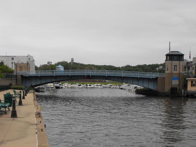
This bridge is the only historic movable bridge in Indiana, and is significant on a state level basis as a result. While the bridge is in northwestern Indiana and thus near Chicago's massive collection of bascule bridges, the Franklin Street Bridge in Indiana remains noteworthy as a historic bascule bridge that is a plate girder rather than a truss. Chicago used the truss form for its bascule bridges, so this plate girder bascule is still regionally an uncommon find. The bridge's appearance has more in common with neighboring Michigan which nearly exclusively used plate girders instead of trusses for the bascule bridges in its many lakeshore towns. However, nearly all of Michigan's historic bascule bridges do not retain original railings, while this Indiana bridge retains attractive original railings. Indeed, the Franklin Street Bridge is historically complete, with railings, bridge tender building, plaques, and riveted girders. It appears to have been well maintained and the bridge should continue to be maintained as an important Indiana historic bridge. Located near to a park and a historic lighthouse, and not too far from the old train station, this bridge adds to the attraction, heritage, and desirability of the area.
History and Discussion of a Previous 1908 Franklin Street Bridge
In 1908, an old swing bridge was demolished and replaced here at Franklin Street with a single leaf bascule bridge. This replacement bascule bridge was apparently only in service for a couple years until June 1910 when the SS United States backed into it and collapsed it into the river.. The bridge was severely damaged. The February 1911 Good Roads magazine posted a notice that read "The City Council has decided to rebuild the Franklin St. bridge without assistance from La Porte Co. The estimated cost is about $17,000." It is not known if it was completely replaced at this time or if the 1908 bridge received a massive repair project. If the $17,000 cost suggests it was a repair project, since the construction cost for the bridge in 1908 was much larger, about $35,000. The bridge seen today would not be built for around another 20 years.
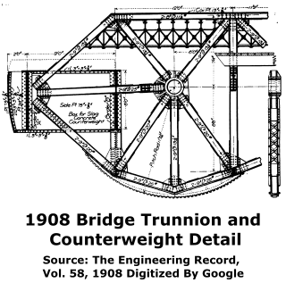
Regardless of its lifespan, the 1908 bascule bridge is of interest. An Engineering Record article discusses the bridge in detail. The initial interest in the bridge is the design, which has an arc-shaped rack on the bottom of the truss that interacted with a pinion to operate the bridge. The location of the rack on the bottom of the truss, below the trunnion, is unusual. The design appears to have only allowed the bridge to raise by a limited number of degrees. The photo seen above may be nearly as high as the bridge could go.
The bridge is additionally of note because the bascule bridge used a patented design. The inventor was listed as Fredrik Borg on the patent. The bascule bridge is actually described as a "Borg bascule." Of further interest is Borg's firm, Borg and Ericson. The "Ericson" of Borg and Ericson is John E. Ericson, who for many years (including in 1908) was the City Engineer for the City of Chicago. It is known that Ericson operated an engineering firm on the side while also being Chicago's City Engineer. Little is currently known about Ericson's this consulting that Ericson did on the side; this bridge is the first solid connection identified with Ericson's outside-of-Chicago consulting. This bascule bridge's steel was fabricated by George W. Jackson, a prominent contractor from Chicago. The total contract cost was about $35,000.
![]()
Photo Galleries and Videos: Franklin Street Bridge
Bridge Photo-Documentation
Original / Full Size PhotosA collection of overview and detail photos. This gallery offers photos in the highest available resolution and file size in a touch-friendly popup viewer.
Alternatively, Browse Without Using Viewer
![]()
Bridge Photo-Documentation
Mobile Optimized PhotosA collection of overview and detail photos. This gallery features data-friendly, fast-loading photos in a touch-friendly popup viewer.
Alternatively, Browse Without Using Viewer
![]()
Maps and Links: Franklin Street Bridge
Coordinates (Latitude, Longitude):
Search For Additional Bridge Listings:
Bridgehunter.com: View listed bridges within 0.5 miles (0.8 kilometers) of this bridge.
Bridgehunter.com: View listed bridges within 10 miles (16 kilometers) of this bridge.
Additional Maps:
Google Streetview (If Available)
GeoHack (Additional Links and Coordinates)
Apple Maps (Via DuckDuckGo Search)
Apple Maps (Apple devices only)
Android: Open Location In Your Map or GPS App
Flickr Gallery (Find Nearby Photos)
Wikimedia Commons (Find Nearby Photos)
Directions Via Sygic For Android
Directions Via Sygic For iOS and Android Dolphin Browser
USGS National Map (United States Only)
Historical USGS Topo Maps (United States Only)
Historic Aerials (United States Only)
CalTopo Maps (United States Only)


