

View Information About HSR Ratings

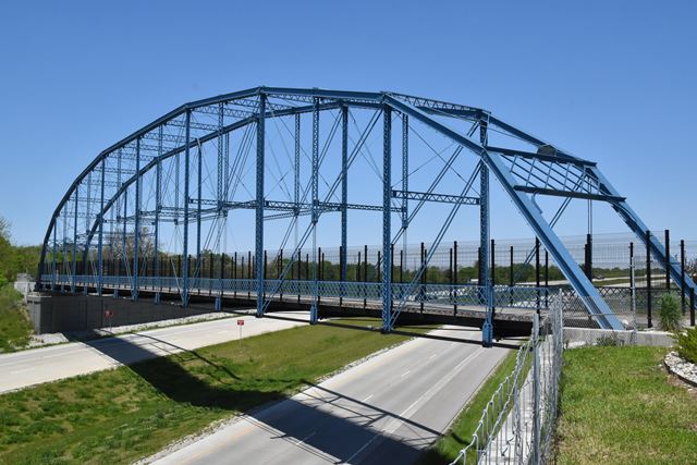
This bridge has an impressive history. It was constructed in 1898 as a replacement for two spans of a multi-span covered bridge that was partuially destroyed. This location was in Freedom (Owen County) Indiana, CR-590 over the White River. In 2001 it was replaced, and put into storage and after some change in plans the final decision was to restore and erect the bridge over IN-25 at Delphi (Carroll County) Indiana as a pedestrian overpass. Here, the bridge carries the Monon High Bridge Trail.
There are two things that make this bridge unique and highly noteworthy. Firstly, the bridge is historically significant as a pin-connected Pennsylvania truss. This is a complex truss configuration that represents a significant design, fabrication, and erection effort. It was used for long simple truss spans. In the context of Indiana, it is notable for its long span length and construction date. The bridge also retains good historic integrity with few notable alterations to the truss.
This bridge is also unique and significant for its reuse as a pedestrian overpass on a limited access highway. While it is possible some historians might question the different use of the bridge since it was originally designed to carry a road over a river, a quick visit to this bridge should convince most people that this is a spectacular reuse of this bridge. Expressways are notoriously boring and devoid of scenery (this one being no exception), so in such a setting this amazing bridge is a welcome and stunning interuption to the monotony of expressway driving. The experience for a driver on IN-25 is very impressive with the large truss looming over the highway. The height of the truss at center span from lower chord pin to upper chord pin is 44.5 feet. It also offers drivers a nearly mid-span elevation view of the Pennsylvania truss, allowing for the complex truss design to be recognized and seen. This angle of viewing would often be difficult to acquire without a boat if the bridge were over a river. For pedestrians walking on the bridge the bridge offers an equally impressive experience as the complex, tall truss rises over the walkway. As an overpass bridge, it by its nature has to have tall fencing to keep people from throwing things on the highway below. This fencing would all but block the view of many truss bridge types, such as a pony truss, or even a typical Pratt truss. But for a long, tall, complex span like this Pennsylvania truss, the fencing is easy to ignore as most of the "visual action" including many truss members and all the overhead bracing occurs above the top of the fence line.
It is hoped this bridge's reuse will inspire similar projects elsewhere.
Information and Findings From DHPA Historic Bridge SurveyArchitectural Description The Lafayette Bridge Company of Lafayette, Indiana, fabricated the pin-connected Pennsylvania through-truss span at the center of this structure. The old span rests upon the original cut stone abutment and pier. Four concrete-encased steel beam approaches extend to the west upon concrete piers and the original stone abutment. Alternating verticals of laced channels and laced double angles divide the through span into sixteen panels. A two-panel side section has been added to the standard twelve-panel pattern. The four-panel central section contains a member fabricated of laced double angles which is placed parallel to and midway between the chords in the two most central panels and uses double-intersecting diagonals and counters (with adjustable sub-ties). Each of the two double-panel side sections has double-intersecting diagonals and adjustable sub-ties, too. The side section closest to center also contains the added horizontal member between the chords. Double die-forged eye-bars provide all the diagonals. Riveted to pin-plates, the I floor-beams carry the concrete deck with its 16' roadway and 13'6" of vertical clearance. The only extant Pennsylvania trusses built by this once prolific Indiana firm, this structure is unusual for extending the twelve-panel pattern to sixteen with extra side sections. The through truss retains its original members, including curved portal braces and decoratively latticed portals and guardrails. The superstructure was dismantled in 2001 and moved to Conner Prairie for restoration and re-erection. Conner Prairie canceled the project and donated the superstructure members to the City of Delphi where restoration and re-erection on the Monon trail over the Hoosier Heartland Highway are slated for 2015. References Beam, Longest & Neff, Inc., Owen County Bridge Inventory Rating & Safety Inspection (Indianapolis, 1973, 1996). Associated Engineering Consultants, Inc., Bridge Reinspection Study & Report: Owen County (Nashville, 1978). bridge nameplate. Bridge Considered Historic By Survey: Yes |
![]()
![]()
![]()
The bridge was previously located at these coordinates: 39.20528, -86.86583.
Coordinates (Latitude, Longitude):
Search For Additional Bridge Listings:
Bridgehunter.com: View listed bridges within 0.5 miles (0.8 kilometers) of this bridge.
Bridgehunter.com: View listed bridges within 10 miles (16 kilometers) of this bridge.
Additional Maps:
Google Streetview (If Available)
GeoHack (Additional Links and Coordinates)
Apple Maps (Via DuckDuckGo Search)
Apple Maps (Apple devices only)
Android: Open Location In Your Map or GPS App
Flickr Gallery (Find Nearby Photos)
Wikimedia Commons (Find Nearby Photos)
Directions Via Sygic For Android
Directions Via Sygic For iOS and Android Dolphin Browser
USGS National Map (United States Only)
Historical USGS Topo Maps (United States Only)
Historic Aerials (United States Only)
CalTopo Maps (United States Only)

© Copyright 2003-2026, HistoricBridges.org. All Rights Reserved. Disclaimer: HistoricBridges.org is a volunteer group of private citizens. HistoricBridges.org is NOT a government agency, does not represent or work with any governmental agencies, nor is it in any way associated with any government agency or any non-profit organization. While we strive for accuracy in our factual content, HistoricBridges.org offers no guarantee of accuracy. Information is provided "as is" without warranty of any kind, either expressed or implied. Information could include technical inaccuracies or errors of omission. Opinions and commentary are the opinions of the respective HistoricBridges.org member who made them and do not necessarily represent the views of anyone else, including any outside photographers whose images may appear on the page in which the commentary appears. HistoricBridges.org does not bear any responsibility for any consequences resulting from the use of this or any other HistoricBridges.org information. Owners and users of bridges have the responsibility of correctly following all applicable laws, rules, and regulations, regardless of any HistoricBridges.org information.
![]()