

View Information About HSR Ratings
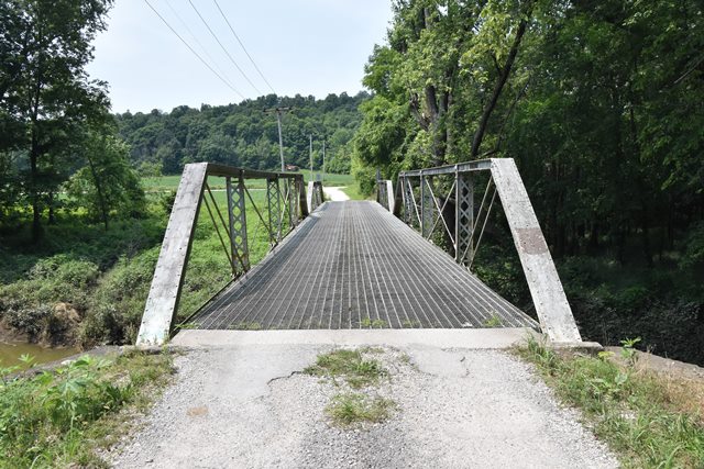
This bridge with its two unequal spans is a rare example of a multi-span pin-connected pony truss bridge. Most surviving pony truss bridges with pin connections are single span bridges. This bridge is also a notable example of the Champion Bridge Company, which was more prolific in other states like Ohio and Tennessee.
The National Bridge Inventory showed a 1913 construction date, however the DHPA notes listed a ca. 1900 date. Given the lightweight trusses, and built-up floorbeams, and the stone substructure, the 1900 date seems more likely.
Information and Findings From DHPA Historic Bridge SurveyBridge History and Significance Built by the Champion Bridge Company of Wilmington, Ohio, the two-span, pin-connected Pratt pony truss rests upon its original cut stone abutments, wingwalls, and pier. The structure extends 113' in three and four panels each. Its verticals are fabricated of laced pairs of angles and its diagonals of a pair of die-forged and rectangular eyebars countered by an adjustable bar in the center panels of the longest span and crossed in the center panel of the shortest span. I floor-beams, which are double U-bolted to the lower pins, carry the timber deck with its 12' roadway. One of three extant Pratt ponies fabricated by the prolific Ohio firm, this is also one of the three surviving two-span structures of this truss type in Indiana. The unadorned bridge retains its original substructure and metal members, although some have undergone repair. The truss design is quite standard. References Bridge nameplate. American Consulting Engineers, Inc., Bridge Inspection/Reinspection Report: Martin County (Indianapolis, 1974, 1979). Bridge Considered Historic By Survey: Yes |
![]()
![]()
![]()
Coordinates (Latitude, Longitude):
Search For Additional Bridge Listings:
Bridgehunter.com: View listed bridges within 0.5 miles (0.8 kilometers) of this bridge.
Bridgehunter.com: View listed bridges within 10 miles (16 kilometers) of this bridge.
Additional Maps:
Google Streetview (If Available)
GeoHack (Additional Links and Coordinates)
Apple Maps (Via DuckDuckGo Search)
Apple Maps (Apple devices only)
Android: Open Location In Your Map or GPS App
Flickr Gallery (Find Nearby Photos)
Wikimedia Commons (Find Nearby Photos)
Directions Via Sygic For Android
Directions Via Sygic For iOS and Android Dolphin Browser
USGS National Map (United States Only)
Historical USGS Topo Maps (United States Only)
Historic Aerials (United States Only)
CalTopo Maps (United States Only)

© Copyright 2003-2026, HistoricBridges.org. All Rights Reserved. Disclaimer: HistoricBridges.org is a volunteer group of private citizens. HistoricBridges.org is NOT a government agency, does not represent or work with any governmental agencies, nor is it in any way associated with any government agency or any non-profit organization. While we strive for accuracy in our factual content, HistoricBridges.org offers no guarantee of accuracy. Information is provided "as is" without warranty of any kind, either expressed or implied. Information could include technical inaccuracies or errors of omission. Opinions and commentary are the opinions of the respective HistoricBridges.org member who made them and do not necessarily represent the views of anyone else, including any outside photographers whose images may appear on the page in which the commentary appears. HistoricBridges.org does not bear any responsibility for any consequences resulting from the use of this or any other HistoricBridges.org information. Owners and users of bridges have the responsibility of correctly following all applicable laws, rules, and regulations, regardless of any HistoricBridges.org information.
![]()