We Recommend:
Bach Steel - Experts at historic truss bridge restoration.
BridgeHunter.com Phase 1 is released to the public! - Visit Now
Illinois Street Bridge
Marion County Bridge 1111

Primary Photographer(s): Nathan Holth
Bridge Documented: February 19, 2017
Illinois Street Over Indiana Central Canal (Indianapolis Water Company Canal)
Indianapolis: Marion County, Indiana: United States
1920 By Builder/Contractor: National Concrete Company of Indianapolis, Indiana and Engineer/Design: Daniel Luten
1946
61.4 Feet (18.7 Meters)
147.0 Feet (44.8 Meters)
25.3 Feet (7.71 Meters)
2 Main Span(s)
4900078

View Information About HSR Ratings
Bridge Documentation
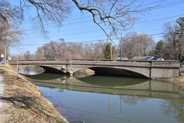
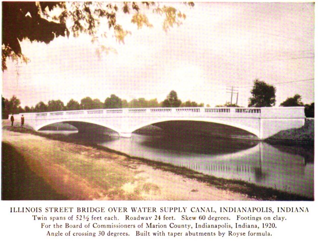
Indiana bridge historian Dr. Jim Cooper researched this bridge and provided the following additional history: The county council appropriated $27,500 in July 1919 for construction of a bridge over the canal on Illinois street. The commissioners, in turn, contracted with the National Concrete Co. to build this Luten-design two-span for $25,860 in October 1919. Construction was completed by August 1920. Luten featured this bridge with its 60° offset in his 1921 pamphlet on Skew Arches. In his 1924 publication, he also noted that the structure was "built with taper abutments by Royse formula". The quite skewed, elliptical rings springs from the abutments and pier close to stream-bed level. The spandrel walls and abutment panels are bush-hammered. The original coped and paneled railing with neo-classical balusters were replaced in 1946 with coped and closed-panel rails. The rails lined the sidewalks which bordered the bituminous roadway.
View Archived National Bridge Inventory Report - Has Additional Details and Evaluation
This bridge was shown in the National Bridge Inventory with a 1946 construction date. However, Indiana bridge historian Dr. Jim Cooper notes a 1920 construction date for this bridge. The bridge appears in a 1924 National Concrete Company catalog, showing its design by famous engineer Daniel Luten. In this photo (shown below) the bridge has balustrade railings. It is possible that the 1946 date in the National Bridge Inventory references a repair project and railing replacement. Solid paneled railings like those seen on the bridge today were still in use in Indiana in the 1940s.
This bridge is tagged with the following special condition(s): Luten
![]()
Photo Galleries and Videos: Illinois Street Bridge
Bridge Photo-Documentation
Original / Full Size PhotosA collection of overview and detail photos. This gallery offers photos in the highest available resolution and file size in a touch-friendly popup viewer.
Alternatively, Browse Without Using Viewer
![]()
Bridge Photo-Documentation
Mobile Optimized PhotosA collection of overview and detail photos. This gallery features data-friendly, fast-loading photos in a touch-friendly popup viewer.
Alternatively, Browse Without Using Viewer
![]()
Maps and Links: Illinois Street Bridge
Coordinates (Latitude, Longitude):
Search For Additional Bridge Listings:
Bridgehunter.com: View listed bridges within 0.5 miles (0.8 kilometers) of this bridge.
Bridgehunter.com: View listed bridges within 10 miles (16 kilometers) of this bridge.
Additional Maps:
Google Streetview (If Available)
GeoHack (Additional Links and Coordinates)
Apple Maps (Via DuckDuckGo Search)
Apple Maps (Apple devices only)
Android: Open Location In Your Map or GPS App
Flickr Gallery (Find Nearby Photos)
Wikimedia Commons (Find Nearby Photos)
Directions Via Sygic For Android
Directions Via Sygic For iOS and Android Dolphin Browser
USGS National Map (United States Only)
Historical USGS Topo Maps (United States Only)
Historic Aerials (United States Only)
CalTopo Maps (United States Only)


