

View Information About HSR Ratings
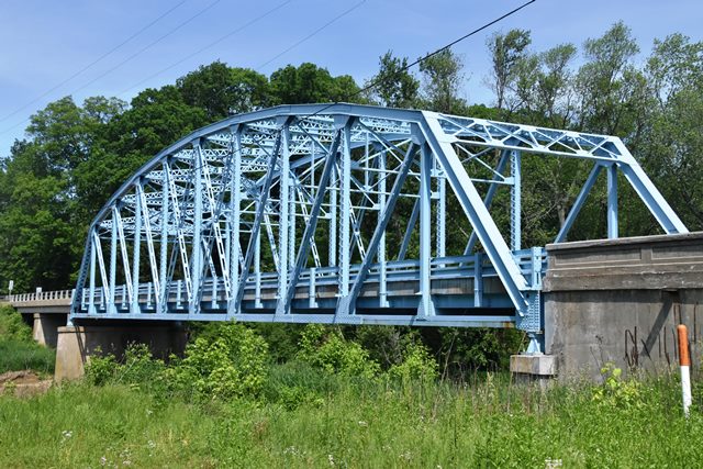
This is an excellent example of a state standard plan through truss in Indiana. The original t-beam approach spans were replaced with pre-stressed concrete spans.
Information and Findings From DHPA Historic Bridge SurveyDiscussion of Truss Bridge For previous structure, see Clay County, Poland Beach Covered Bridge. ISHC did not long keep on its roadways the timber trusses that it inherited from the counties. In 1937, it advertised to replace the old covered bridge with a three-span of state design. R. McCalman, Inc. of Danville, Indiana, successfully bid $45,434.69 in January 1938 to build the two 40-ft. reinforced concrete T-beam approach spans, the pier and abutment for a steel truss, and the coped approach railings with bush-hammered panels. The Vincennes Bridge Company of Vincennes, Indiana, won the contract to fabricate the truss for $22,704.59. The job was completed by early 1939. The ISHC used revised versions of the third-generation standard plan #475A for a 175-ft., riveted, Parker through-truss span with a 24-ft. roadway for this and a dozen other structures. Truss depth varied from 21 ft. 6 in. at the portal to 31 ft. 6 in. at midspan. Each truss carried ten 17-ft. 6-in. panels. Every top chord member is differently sloped; none is parallel with the lower chord; and all were fabricated from a pair of 15-in. channels (@40# for the endposts, fourth, and fifth panels, and @33.3# for the second and third). Two pairs of angles--all of the same size (6"x4"Ls)--riveted together with battens and buttressed in all but the two most outer panels with plates provide the lower chord's members. The truss webbing is also substantial. The verticals or posts, except for the hip one, consist of a pair of laced 10-in. channels (@15.3#). A 10-in. I (@39#) supplied the hip vertical. To protect the quite-tall trusses against wind and vehicle-induced stress, the verticals are buttressed with substantial latticed struts and heavy upper sway framing above the 15 ft. of roadway clearance. The portals used latticed sections, too. The diagonals combined a pair of angles with battens into heavier members in the outer panels (6"x4"Ls) than in the central ones (3.5"x3"Ls). A pair of angles (3"x3"Ls) and battens provide counters in the two most central panels. The ISHC used 33-in. I floor-beams (@141#) riveted to the verticals above the lower chord. Eight rows of heavy rolled I stringers (16"@36#) are attached to the floor-beams' sides. Together, the floor-beams and the stringers carry the concrete deck. A pair of angles supplies each lower sway- bracing member. Post-and-channel rails lined the inner sides of the trusses. From drift, to ferry, to covered timber trusses, this has been a traditional crossing of the Eel River. The steel span at the heart of the current structure illustrates a much-used, revised third-generation ISHC standard plan. The trusses--fabricated by a most-important Indiana builder--retain their original members. The original guard rails and concrete deck have been replaced, although the truss' coped concrete approach rails with bush-hammered panels remain. The two reinforced concrete T-beam spans have been replaced with continuous prestressed concrete I-beams. References Indiana State Highway Commission, Inventory of Bridges on State Highway System of Indiana (Indianapolis, 1989); Structure #42-C-3101; Contract #1586A & B; Superstructure Standard #475A. William Travis, History of Clay County (Chicago, 1909), I: 67-68, 73. Discussion of Previous Covered Bridge The sometimes sluggish Eel River gathered a major drift--the Rizley--in this area that early footmen often used as a natural bridge. William Parker ran a ferry at the road crossing from 1835 until Muehler and McNamara erected the Poland Beach Bridge, a 160-ft., Burr arch truss span around 1872. William B. Parker established a ferry across the Eel River directly west of Poland and operated it until 1872 when a bridge was built a short distance upstream by Muehler & Notter for $7,200. In 1882, Muehler & Notter received a $1,495 contract to build wing-walls for the Poland Bridge. The county sought bids in 1904 for "repair and strengthening of the floor system" of the Poland Bridge over Eel River. R. R. Moorman brought in the lowest and therefore the accepted proposal for $728. In 1932, the commissioners ordered the Pipe Line Co. to repair to siding of the Poland Bridge. For succeeding structures, see Clay County, State Highway Bridge #3101. References Clay County, "Commissioners Record," 9: 116, 139, 161,222; 20: 552-554; 34: 11. George E. Gould, Indiana Covered Bridges Thru the Years (1977), 30. William Travis, History of Clay County, Indiana (Chicago, 1909), 67-68, 73. Bridge Considered Historic By Survey: Yes |
![]()
![]()
![]()
Coordinates (Latitude, Longitude):
Search For Additional Bridge Listings:
Bridgehunter.com: View listed bridges within 0.5 miles (0.8 kilometers) of this bridge.
Bridgehunter.com: View listed bridges within 10 miles (16 kilometers) of this bridge.
Additional Maps:
Google Streetview (If Available)
GeoHack (Additional Links and Coordinates)
Apple Maps (Via DuckDuckGo Search)
Apple Maps (Apple devices only)
Android: Open Location In Your Map or GPS App
Flickr Gallery (Find Nearby Photos)
Wikimedia Commons (Find Nearby Photos)
Directions Via Sygic For Android
Directions Via Sygic For iOS and Android Dolphin Browser
USGS National Map (United States Only)
Historical USGS Topo Maps (United States Only)
Historic Aerials (United States Only)
CalTopo Maps (United States Only)

© Copyright 2003-2026, HistoricBridges.org. All Rights Reserved. Disclaimer: HistoricBridges.org is a volunteer group of private citizens. HistoricBridges.org is NOT a government agency, does not represent or work with any governmental agencies, nor is it in any way associated with any government agency or any non-profit organization. While we strive for accuracy in our factual content, HistoricBridges.org offers no guarantee of accuracy. Information is provided "as is" without warranty of any kind, either expressed or implied. Information could include technical inaccuracies or errors of omission. Opinions and commentary are the opinions of the respective HistoricBridges.org member who made them and do not necessarily represent the views of anyone else, including any outside photographers whose images may appear on the page in which the commentary appears. HistoricBridges.org does not bear any responsibility for any consequences resulting from the use of this or any other HistoricBridges.org information. Owners and users of bridges have the responsibility of correctly following all applicable laws, rules, and regulations, regardless of any HistoricBridges.org information.
![]()