

View Information About HSR Ratings
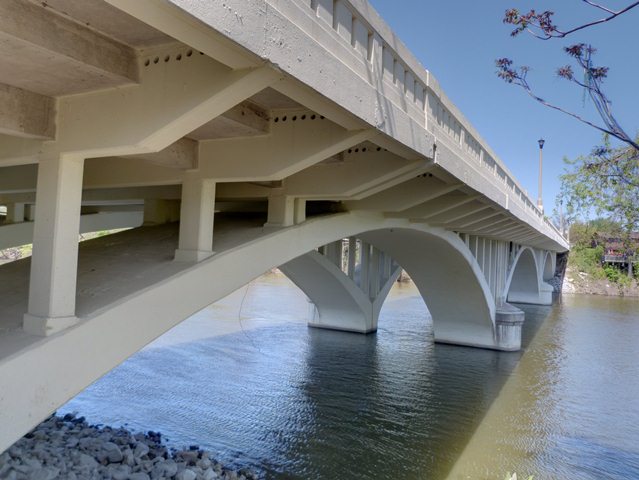
This open-spandrel bridge is one of the larger structures in South Bend, featuring a larger vertical clearance that other examples. It is unclear whether the railings on the bridge are original or not. They utilize a design unlike the other South Bend bridges, but this could mean anything. The main arch superstructure however does appear to be intact, and still creates an impressive bridge to look at. A visit in 2012 revealed that the bridge has been repaired and coated with a sealant. This occurred sometime after the initial 2006 visit to the bridge. Previous rehabilitations had occured in 1969-1970 and in 2000.
Information and Findings From DHPA Historic Bridge SurveyStatement of Significance Indiana's counties and cities built only a couple of open-spandrel bridges in the decade before the Second World War. The rings of this structure are unusually flat and the use of spandrel piers of additional note. While the replacement feck somewhat reduces the architectural integrity of the bridge, it retains all its original structural elements. Architectural Description
Open-spandrel arches are more economical than the
common solid-spandrel and filled arches only where the distance between
the roadway and the stream and the volume which the watercourse carried
were both considerable. In such circumstances the amount of concrete and
reinforcement needed to compensate for the weight of the required fill
and the length of the span sometimes tipped the balance towards
open-spandrels. The more graceful appearance of open-spandrels sometimes
contributed to their selection, especially in urban settings. County Engineer R. J. Lang prepared plans for a 4-span filled spandrel arch estimated to cost $231,650; National Concrete successfully bid $159,500 to build 3 span open spandrel of Luten design; 478 feet long; 122-130 ft spans; 2 ribs per span; spandrel piers; new cantilevered slab deck (1970), removed balustraded rails and lampposts with cast bronze fixtures. Bridge Considered Historic By Survey: Yes |
This bridge is tagged with the following special condition(s): Luten
![]()
![]()
![]()
Coordinates (Latitude, Longitude):
Search For Additional Bridge Listings:
Bridgehunter.com: View listed bridges within 0.5 miles (0.8 kilometers) of this bridge.
Bridgehunter.com: View listed bridges within 10 miles (16 kilometers) of this bridge.
Additional Maps:
Google Streetview (If Available)
GeoHack (Additional Links and Coordinates)
Apple Maps (Via DuckDuckGo Search)
Apple Maps (Apple devices only)
Android: Open Location In Your Map or GPS App
Flickr Gallery (Find Nearby Photos)
Wikimedia Commons (Find Nearby Photos)
Directions Via Sygic For Android
Directions Via Sygic For iOS and Android Dolphin Browser
USGS National Map (United States Only)
Historical USGS Topo Maps (United States Only)
Historic Aerials (United States Only)
CalTopo Maps (United States Only)

© Copyright 2003-2026, HistoricBridges.org. All Rights Reserved. Disclaimer: HistoricBridges.org is a volunteer group of private citizens. HistoricBridges.org is NOT a government agency, does not represent or work with any governmental agencies, nor is it in any way associated with any government agency or any non-profit organization. While we strive for accuracy in our factual content, HistoricBridges.org offers no guarantee of accuracy. Information is provided "as is" without warranty of any kind, either expressed or implied. Information could include technical inaccuracies or errors of omission. Opinions and commentary are the opinions of the respective HistoricBridges.org member who made them and do not necessarily represent the views of anyone else, including any outside photographers whose images may appear on the page in which the commentary appears. HistoricBridges.org does not bear any responsibility for any consequences resulting from the use of this or any other HistoricBridges.org information. Owners and users of bridges have the responsibility of correctly following all applicable laws, rules, and regulations, regardless of any HistoricBridges.org information.
![]()
