

View Information About HSR Ratings
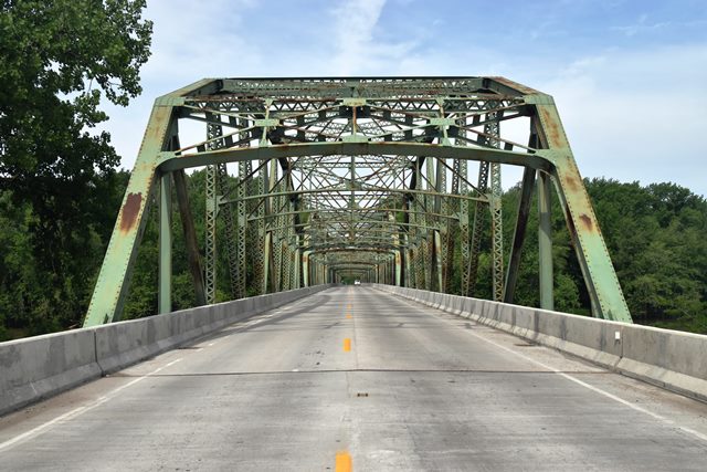
This bridge is one of the longest surviving examples of Indiana's beautiful standard through truss design. The bridge was rehabilitated in 1987, and the deck was replaced in 2018.

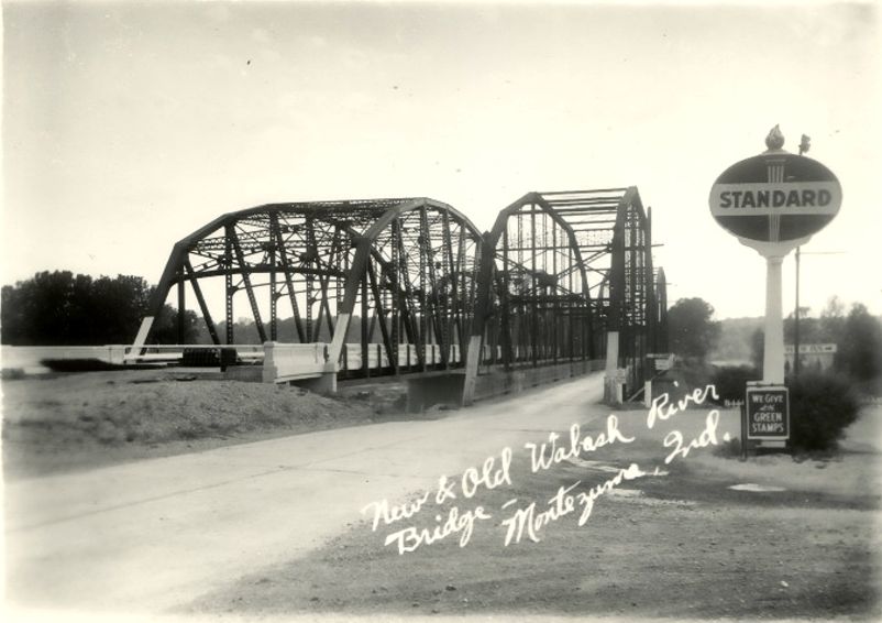
Above: Historical photo showing previous bridge at this location. It was a Pennsylvania through truss built by the Wrought Iron Bridge Company, which is very rare as this truss type was not normally built by the company. The portal bracing was also a non-standard design for the company nationwide, but one which was used on several bridges in Indiana.

Newspaper photo from January 31st, 1941 showing the collapse of the westernmost span of the previous bridge at this location.
Historical photo showing the newly completed bridge, with the surviving spans of the previous bridge still standing.
Information and Findings From DHPA Historic Bridge SurveyStatement of Significance Surveyed Structure Robert H. King of Danville, Indiana, secured contracts for the substructure and superstructure of this substantial structure. He won the state's nod to build the concrete piers and abutments for $421,823.55 in August 1947 and to erect the six-span Parker through-truss superstructures for $451,185.03 in March 1948. King completed his work by December 1948. New approaches came at least a year later. In December 1949, the Calumet Paving Company of Zionsville, Indiana got a $256,244.85 contract for the approaches. The ISHC developed and used this late standard plan #1554 for a 200-ft. span with a 28-ft. roadway sandwiched between a pair of 2-ft. walks. Truss depth varied from 24 ft. at the portal to 39 ft. at midspan. Each truss carried nine panels, the outer two on each end at 20 ft. 7.5 in. and the inner five at 23 ft. 6 in. Every top chord member is differently sloped; only the central panel's one is parallel with the lower chord; and all were fabricated from a pair of 15-in. channels (@50# for the endposts, third, fourth, and fifth panels, and @40# for the second). For the lower chord, 12-in. rolled I-bars grow in weight from the outer panels (@72#) to the inner-most one (@133#). The state used rolled I-beams in a few web members. The verticals or posts consist of two forms and weights: the hip vertical is a 12-in. I-beam (@40#); the others are made from a pair of laced 10-in. channels (@15.3#). To protect the quite-tall trusses against wind and vehicle-induced stress, substantial latticed struts and heavy upper sway framing buttress the verticals above 15 ft. of roadway clearance. The portals used latticed sections, too. While a 12-in. I-beam (@45#) provided the second-panel diagonal, the third used a pair of laced 10-in. channels (@20#), the fourth a pair of 12-in. channels (@20.7#), and the fifth a 12-in. I-beam (@27#). Only the central panel was countered. The ISHC prescribed 33-in. I floor-beams (@200#) riveted to the verticals above the lower chord. The nine rows of rolled I-beam stringers attached to the floor-beams' sides varied in depth and weight by placement. The 20-ft. 7.5-in. panels used 16-in. Is at 36 lbs. on the outside up to 50 lbs. towards the center. The 23-ft. 6-in. panels relied on 18-in. Is at 50 lbs. outside up to 55 lbs. approaching center. Together, the floor-beams and the stringers carry the concrete deck. Angles supply each lower sway-bracing member. Tube-channel-and-post rails lined the inner sides of the trusses, and coped concrete approach rails with bush-hammered panels funneled traffic into the spans. In 1987, the state replaced the concrete approach rails on each end with a 28-ft. 9-in. reinforced concrete slab span. This bridge is the single structure--a multi-span example at that--built to the last ISHC standard for a 200-ft. trussed span. While the trusses retain their original members, the complete rehabilitation of the deck substituted approach spans for the concrete rails, removed the walks to widen the roadway, and eliminated the metal guardrails for Jersey-barrier style concrete curb railings. King is a notable builder, having constructed for the ISHC in every decade of its existence before and including the Forties. ISHC Structure #36-B-3492 Contracts #2811, #2938, #3131 Superstructure Standard #1554 Statement of Significance (Previous 1892 Bridge) The Parke County commissioners allowed the Wrought Iron Bridge Company $17,811.80 on its "final estimate" for the "Montezuma Bridge" in February 1893. John T. Cambell, in turn, received $116 for service as superintendent of construction on the bridge. Others won about $100 for "labor" on the bridge. The Parke County auditor noted in June the distribution during the previous year of $28,506.65 of the bonded amount of $36,468.84. In September 1893, the Parke commissioners contracted with the Wrought Iron Bridge Company at $4,800 to install "ice breaks" on the new Montezuma Bridge. Wrought Iron was allowed the contracted amount in two installments in December 1893 and January 1894. J. W. Vanlandingham also received $30 for labor on the project. In October 1894, G. W & C. H. King won a contract "for filling ice breaks" on the Montezuma Bridge for $1.28 per cubic foot. Allowance for filling the ice breaks and supervising the labor totalled almost $1,000 in December. For successor structure, see Vermillion {83} #3492 References Parke County, "Commissioners Record," 15: 124-125, 142-144, 199, 260, 320, 323, 325, 352, 390, 450, 494. Bridge Considered Historic By Survey: Yes |
![]()
![]()
![]()
Coordinates (Latitude, Longitude):
Search For Additional Bridge Listings:
Bridgehunter.com: View listed bridges within 0.5 miles (0.8 kilometers) of this bridge.
Bridgehunter.com: View listed bridges within 10 miles (16 kilometers) of this bridge.
Additional Maps:
Google Streetview (If Available)
GeoHack (Additional Links and Coordinates)
Apple Maps (Via DuckDuckGo Search)
Apple Maps (Apple devices only)
Android: Open Location In Your Map or GPS App
Flickr Gallery (Find Nearby Photos)
Wikimedia Commons (Find Nearby Photos)
Directions Via Sygic For Android
Directions Via Sygic For iOS and Android Dolphin Browser
USGS National Map (United States Only)
Historical USGS Topo Maps (United States Only)
Historic Aerials (United States Only)
CalTopo Maps (United States Only)

© Copyright 2003-2026, HistoricBridges.org. All Rights Reserved. Disclaimer: HistoricBridges.org is a volunteer group of private citizens. HistoricBridges.org is NOT a government agency, does not represent or work with any governmental agencies, nor is it in any way associated with any government agency or any non-profit organization. While we strive for accuracy in our factual content, HistoricBridges.org offers no guarantee of accuracy. Information is provided "as is" without warranty of any kind, either expressed or implied. Information could include technical inaccuracies or errors of omission. Opinions and commentary are the opinions of the respective HistoricBridges.org member who made them and do not necessarily represent the views of anyone else, including any outside photographers whose images may appear on the page in which the commentary appears. HistoricBridges.org does not bear any responsibility for any consequences resulting from the use of this or any other HistoricBridges.org information. Owners and users of bridges have the responsibility of correctly following all applicable laws, rules, and regulations, regardless of any HistoricBridges.org information.
![]()