We Recommend:
Bach Steel - Experts at historic truss bridge restoration.
BridgeHunter.com Phase 1 is released to the public! - Visit Now
Mt. Carmel - Princeton Free Bridge
Mt. Carmel Bridge

Primary Photographer(s): Nathan Holth and Rick McOmber
Bridge Documented: July 4, 2009
Mt. Carmel: Wabash County, Illinois and Gibson County, Indiana: United States
1932 By Builder/Contractor: Vincennes Bridge Company of Vincennes, Indiana and Engineer/Design: Illinois Division of Highways
1991
227.7 Feet (69.4 Meters)
2,726.0 Feet (830.9 Meters)
22 Feet (6.71 Meters)
12 Main Span(s)
Not Applicable

View Information About HSR Ratings
Bridge Documentation
This bridge no longer exists!
View Archived National Bridge Inventory Report - Has Additional Details and Evaluation
View The Illinois NBI Sheet (Compare to the Indiana NBI Sheet Above)
This historic bridge was demolished February 2011, despite not being in the way of its replacement!
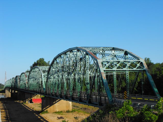
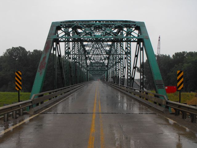
This twelve span through truss bridge appears to be among the longest simple-spanning multiple span through truss highway bridges remaining in existence in both Indiana and Illinois, and perhaps ranks among the top in that category nationwide. As such, the bridge is historically and technologically significant as a major engineering achievement and an impressive example of how long bridges were construction during the period. Also right after this bridge is Maucks Pond Bridge. Although separate bridges, they should be considered a single historic resource.
Indiana and Illinois both decided that the best way to deal with such a beautiful and historically significant bridge is to demolish the Mt. Carmel Bridge. Maucks Pond Bridge is being replaced too. Such a decision is a clear display of how broken both surface transportation and historic preservation policy truly is in the United States. Since a new bridge is under construction on a new alignment, the historic bridge is not in the way of anything. There is absolutely no reason or point to waste money demolishing this bridge!
It is shameful enough that Indiana / INDOT would consider demolishing this historic bridge, however Illinois / IDOT is actually the lead agency for this state line bridge, which makes it even more appalling. Illinois has far less historic truss bridges than most states in the Midwest and Northeastern United States, and as such an extremely rare and significant multi-span bridge like this should be preserved without hesitation. As for Indiana, while the state has overall shown a strong commitment to historic bridge preservation, particularly on the local level, two points bear consideration. First, while locally owned bridges have been preserved, INDOT owned bridges (which include the majority of historic massive member state standard truss bridges in Indiana) are not being preserved. Second, preservation of historic bridges elsewhere does not excuse demolition of a particular bridge. Each bridge should be evaluated for preservation feasibility with common sense. In this case, with the new bridge constructed next to its replacement out of the way of the historic bridge, demolishing this historic bridge serves no other purpose than to destroy history, waste taxpayer dollars, and fill the pockets of scrap steel companies who get to cash in on historic bridge tragedies such as this.
What should be done instead? The bridge is currently safe for vehicular traffic and has no extremely serious problems, and as such, the bridge could likely stand next to its replacement either for pedestrian use or completely abandoned as a historic relic, for decades to come even without preservation work done on it. As such, the bridge should be left standing next to its replacement. The money that would have been used to demolish the bridge could be used to make repairs to the worst conditions on the bridge.
Information and Findings From DHPA Historic Bridge SurveyStatement of Significance The current bridge replaced a long-used ferry crossing of the Wabash. Although not exceptional from a national perspective, the design of the trusses varies in many secondary ways from the IDH's patterns. The spans and the structure, though, are quite long by Indiana standards. A prolific Hoosier builder manufactured the trusses. Aside from contemporary guardrails, the bridge appears to retain all its original members. Architectural Description The Mt. Carmel-Princeton Bridge Company filed
articles of incorporation with the Indiana Secretary of State in January
1927 to build a toll bridge across the Wabash River "if it is impossible
to secure adequate bridge construction in Indiana out of public funds."
The State of Illinois took the initiative in responding to the hint and,
in cooperation with the Indiana Department of Highways, designed a
twelve-span Parker through-truss structure of 2,700'. The Vincennes
Bridge Company built and erected the trusses upon a concrete
substructure for about $400,000. Bridge Considered Historic By Survey: Yes |
![]()
Photo Galleries and Videos: Mt. Carmel - Princeton Free Bridge
2010 Bridge Photo-Documentation
Original / Full Size PhotosA collection of overview and detail photos. This gallery offers photos in the highest available resolution and file size in a touch-friendly popup viewer.
Alternatively, Browse Without Using Viewer
![]()
2010 Bridge Photo-Documentation
Mobile Optimized PhotosA collection of overview and detail photos. This gallery features data-friendly, fast-loading photos in a touch-friendly popup viewer.
Alternatively, Browse Without Using Viewer
![]()
2009 Rainy Day Visit
Original / Full Size PhotosIncludes views from southwest quadrant and views of the plaque. This gallery offers photos in the highest available resolution and file size in a touch-friendly popup viewer.
Alternatively, Browse Without Using Viewer
![]()
2009 Rainy Day Visit
Mobile Optimized PhotosIncludes views from southwest quadrant and views of the plaque. This gallery features data-friendly, fast-loading photos in a touch-friendly popup viewer.
Alternatively, Browse Without Using Viewer
![]()
Westbound Crossing of the Bridge
Full Motion VideoStreaming video of the bridge. Also includes a higher quality downloadable video for greater clarity or offline viewing.
![]()
Eastbound Crossing of the Bridge
Full Motion VideoStreaming video of the bridge. Also includes a higher quality downloadable video for greater clarity or offline viewing.
![]()
Westbound On Bridge Including Maucks Pond Bridge
Full Motion VideoStreaming video of the bridge. Also includes a higher quality downloadable video for greater clarity or offline viewing.
![]()
Maps and Links: Mt. Carmel - Princeton Free Bridge
This historic bridge has been demolished. This map is shown for reference purposes only.
Coordinates (Latitude, Longitude):
Search For Additional Bridge Listings:
Bridgehunter.com: View listed bridges within 0.5 miles (0.8 kilometers) of this bridge.
Bridgehunter.com: View listed bridges within 10 miles (16 kilometers) of this bridge.
Additional Maps:
Google Streetview (If Available)
GeoHack (Additional Links and Coordinates)
Apple Maps (Via DuckDuckGo Search)
Apple Maps (Apple devices only)
Android: Open Location In Your Map or GPS App
Flickr Gallery (Find Nearby Photos)
Wikimedia Commons (Find Nearby Photos)
Directions Via Sygic For Android
Directions Via Sygic For iOS and Android Dolphin Browser
USGS National Map (United States Only)
Historical USGS Topo Maps (United States Only)
Historic Aerials (United States Only)
CalTopo Maps (United States Only)


