We Recommend:
Bach Steel - Experts at historic truss bridge restoration.
BridgeHunter.com Phase 1 is released to the public! - Visit Now
Murray Street Bridge

Primary Photographer(s): Nathan Holth
Bridge Documented: August 24, 2009, March 4, 2012, and May 26, 2022
Goshen: Elkhart County, Indiana: United States
1909 By Builder/Contractor: Elkhart Bridge and Iron Company of Elkhart, Indiana
1924
63.7 Feet (19.4 Meters)
63.7 Feet (19.4 Meters)
15.6 Feet (4.75 Meters)
1 Main Span(s)
Not Applicable

View Information About HSR Ratings
Bridge Documentation
View A Detailed Article By Jim Cooper Discussing The History of this Historic Bridge
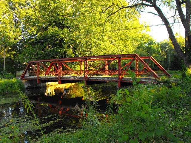
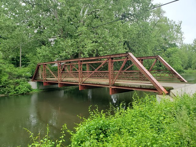
This five panel half-hip Pratt pony truss bridge was built in 1909 and is a rare surviving example of a bridge with a documented association with local bridge builder Elkhart Bridge and Iron Company. This is not the bridge's original location; it was moved here long ago from a different location.
The bridge appears to retain excellent historic integrity. Being located in northern Indiana where there are very few remaining metal truss bridges, this bridge is especially significant on a local/regional basis.
Initial Speculation By HistoricBridges.org
One of the most interesting things on this bridge is the outline image of Indiana with State Road 25 written inside. Labeling a state highway on a truss bridge like this is unusual and looks old fashioned. The paint job on this bridge must not be very recent as such! Anyway, this is very interesting because this would suggest that this bridge was originally a IN-25 state highway bridge. In a 1923 official state highway map, IN-25 is shown following the approximate route of what is today I-80/I-90 (Indiana Tollway). By 1932, IN-25 had moved and now signed its current route according to a 1932 state highway map. That current routing of IN-25 ends in Warsaw at an intersection with IN-15. IN-15 goes north from Warsaw into Goshen. The only way IN-25 would appear to have been associated with Goshen is if at some point this section of IN-15 was a part of IN-25. Either way, it is unlikely that a state highway of any name crossed over the Millrace Canal onto the little island formed by the river and the canal. As such, this bridge would appear to have been relocated. The big question is what the original location was, assuming all this is correct.
More Insight Into The Bridge's History
Jim Cooper later did some more extensive research than HistoricBridges.org, and he produced a detailed narrative. Please be sure to view this narrative to get a more clear and less hypothetical discussion of this bridge's history.
Observations In 2009
The bridge has not been restored, and it needs to be. There is section loss and pack rust in the connections, and some section loss at the base of the endposts. The deck is deteriorated too, largely due to an old asphalt overlay which may have trapped moisture in the original concrete deck below. Plants growing out of the deck signify deterioration and softening of the concrete. The bridge remains safe for the non-motorized traffic it carries, but the sooner a restoration is planned for this bridge the easier it will be to restore the bridge. Given the relative rarity of truss bridges in northern Indiana, this is a significant historic bridge, and in addition it is an important functional link that provides local residents who all live east of the canal, access to the popular Millrace Canal Trail that runs along the west side of the canal.
Current Status of Bridge In 2012
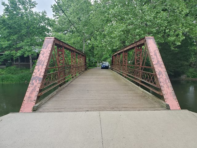
Since this bridge was first documented by HistoricBridges.org, the bridge has been repaired. The deck was replaced with a new wooden deck. Two angles were added as supplemental railing to the bridge, one above and one below the existing hub guard railing. The bridge was also spot painted. Unfortunately, the spot painters painted over the IN-25 symbol on the bridge and they did not paint a new IN-25 symbol on it. Someone should paint that symbol back on the endpost since it helps reveal to visitors the rich history this bridge has.

Above: Bridge in 2022. Photo Credit: Jason Holloway
This bridge is tagged with the following special condition(s): Reused and Unorganized Photos
![]()
Photo Galleries and Videos: Murray Street Bridge
Bridge Photo-Documentation
Original / Full Size PhotosA collection of overview and detail photos. This gallery offers photos in the highest available resolution and file size in a touch-friendly popup viewer.
Alternatively, Browse Without Using Viewer
![]()
Bridge Photo-Documentation
Mobile Optimized PhotosA collection of overview and detail photos. This gallery features data-friendly, fast-loading photos in a touch-friendly popup viewer.
Alternatively, Browse Without Using Viewer
![]()
Additional Unorganized Photos
Original / Full Size PhotosA supplemental collection of photos that are from additional visit(s) to the bridge and have not been organized or captioned. This gallery offers photos in the highest available resolution and file size in a touch-friendly popup viewer.
Alternatively, Browse Without Using Viewer
![]()
Additional Unorganized Photos
Mobile Optimized PhotosA supplemental collection of photos that are from additional visit(s) to the bridge and have not been organized or captioned. This gallery features data-friendly, fast-loading photos in a touch-friendly popup viewer.
Alternatively, Browse Without Using Viewer
![]()
Maps and Links: Murray Street Bridge
Coordinates (Latitude, Longitude):
Search For Additional Bridge Listings:
Bridgehunter.com: View listed bridges within 0.5 miles (0.8 kilometers) of this bridge.
Bridgehunter.com: View listed bridges within 10 miles (16 kilometers) of this bridge.
Additional Maps:
Google Streetview (If Available)
GeoHack (Additional Links and Coordinates)
Apple Maps (Via DuckDuckGo Search)
Apple Maps (Apple devices only)
Android: Open Location In Your Map or GPS App
Flickr Gallery (Find Nearby Photos)
Wikimedia Commons (Find Nearby Photos)
Directions Via Sygic For Android
Directions Via Sygic For iOS and Android Dolphin Browser
USGS National Map (United States Only)
Historical USGS Topo Maps (United States Only)
Historic Aerials (United States Only)
CalTopo Maps (United States Only)


